Bestand:Khazar1.png
Geen hogere resolutie beschikbaar.
Khazar1.png (498 × 448 pixels, bestandsgrootte: 12 kB, MIME-type: image/png)
| Dit is een bestand van Wikimedia Commons. Onderstaande beschrijving komt van de beschrijving van het bestand daar. |
Beschrijving
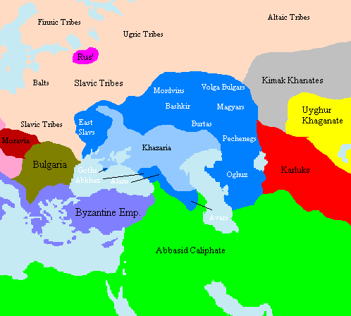
Map showing approximate extent of the w:Khazar w:Khaganate (light blue) and its sphere of influence (dark blue) at its height, c. 820 CE. Polity names in white indicate client-states or tribes of Khazaria.
The source is one of the GFDL World Maps on [1].
Licentie
Taken from en:File:Khazar1.png, created by en.wikipedia.org user Briangotts, who released it under the GPL.
| Dit bestand is gelicenseerd onder de Creative Commons-licentie Naamsvermelding-Gelijk delen 3.0 Unported Onderhevig aan disclaimers. | ||
| ||
| Deze licentietag is toegevoegd aan dit bestand in verband met de GFDL licentie-update. |

|
Toestemming wordt verleend voor het kopiëren, verspreiden en/of wijzigen van dit document onder de voorwaarden van de GNU-licentie voor vrije documentatie, versie 1.2 of enige latere versie als gepubliceerd door de Free Software Foundation; zonder Invariant Sections, zonder Front-Cover Texts, en zonder Back-Cover Texts. Een kopie van de licentie is opgenomen in de sectie GNU-licentie voor vrije documentatie. Onderhevig aan disclaimers. |
Bestandsgeschiedenis
Klik op een datum/tijd om het bestand te zien zoals het destijds was.
| Datum/tijd | Miniatuur | Afmetingen | Gebruiker | Opmerking | |
|---|---|---|---|---|---|
| huidige versie | 16 jun 2022 17:29 | | 498 × 448 (12 kB) | Web3Punkt11 | restore white font labels because "Polity names in white indicate client-states or tribes of Khazaria." --User:Jrohr (originator) |
| 11 okt 2012 12:44 |  | 498 × 448 (19 kB) | MicBy67 | Hintergrundfarben angepasst | |
| 17 jan 2006 11:10 |  | 498 × 448 (17 kB) | Jrohr | == Summary == Map showing approximate extent of the w:Khazar w:Khaganate (light blue) and its sphere of influence (dark blue) at its height, c. 820 CE. Polity names in white indicate client-states or tribes of Khazaria. [[Category:Historical map |
Bestandsgebruik
Dit bestand wordt op de volgende 3 pagina's gebruikt:
Globaal bestandsgebruik
De volgende andere wiki's gebruiken dit bestand:
- Gebruikt op de.wikipedia.org
- Gebruikt op en.wikipedia.org
- Gebruikt op fi.wikipedia.org
- Gebruikt op fr.wikipedia.org
- Gebruikt op he.wikipedia.org
- Gebruikt op lt.wikipedia.org
- Gebruikt op pl.wikipedia.org
- Gebruikt op ru.wikipedia.org
- Gebruikt op tt.wikipedia.org