Bestand:Karte Aut Ooe SE.png
Geen hogere resolutie beschikbaar.
Karte_Aut_Ooe_SE.png (300 × 265 pixels, bestandsgrootte: 4 kB, MIME-type: image/png)
| Dit is een bestand van Wikimedia Commons. Onderstaande beschrijving komt van de beschrijving van het bestand daar. |
Beschrijving
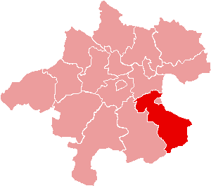
| Beschrijving | Location of Bezirk Steyr-Land within the Land of Upper Austria |
| Datum | |
| Bron | de:Bild:Karte Aut Ooe SE.png |
| Auteur | de:Benutzer:Plp |
| Toestemming (Hergebruik van dit bestand) |
GFDL-author (licence from German Wikipedia) |
| Andere versies | de:Bild:Karte Aut Ooe SE.png |
Licentie

|
Toestemming wordt verleend voor het kopiëren, verspreiden en/of wijzigen van dit document onder de voorwaarden van de GNU-licentie voor vrije documentatie, versie 1.2 of enige latere versie als gepubliceerd door de Free Software Foundation; zonder Invariant Sections, zonder Front-Cover Texts, en zonder Back-Cover Texts. Een kopie van de licentie is opgenomen in de sectie GNU-licentie voor vrije documentatie. |
| Dit bestand is gelicenseerd onder de Creative Commons-licentie Naamsvermelding-Gelijk delen 3.0 Unported | ||
| ||
| Deze licentietag is toegevoegd aan dit bestand in verband met de GFDL licentie-update. |
Bestandsgeschiedenis
Klik op een datum/tijd om het bestand te zien zoals het destijds was.
| Datum/tijd | Miniatuur | Afmetingen | Gebruiker | Opmerking | |
|---|---|---|---|---|---|
| huidige versie | 23 jun 2006 17:17 | | 300 × 265 (4 kB) | Physchim62 | {{Information |Description=Location of Bezirk Steyr-Land within the Land of Upper Austria |Source=de:Bild:Karte Aut Ooe SE.png |Date=2004 |Author=de:Benutzer:Plp |Permission=GFDL-autho |
Bestandsgebruik
Dit bestand wordt op de volgende 2 pagina's gebruikt:
Globaal bestandsgebruik
De volgende andere wiki's gebruiken dit bestand:
- Gebruikt op bs.wikipedia.org
- Gebruikt op ce.wikipedia.org
- Gebruikt op cs.wikipedia.org
- Gebruikt op de.wikipedia.org
- Gebruikt op es.wikipedia.org
- Gebruikt op fa.wikipedia.org
- Gebruikt op fr.wikipedia.org
- District de Steyr-Land
- Gaflenz
- Modèle:Palette District de Steyr-Land
- Adlwang
- Aschach an der Steyr
- Bad Hall
- Dietach
- Garsten
- Laussa
- Losenstein
- Maria Neustift
- Pfarrkirchen bei Bad Hall
- Reichraming
- Großraming
- Rohr im Kremstal
- Schiedlberg
- Sierning
- Sankt Ulrich bei Steyr
- Ternberg
- Waldneukirchen
- Wolfern
- Weyer (Autriche)
- Gebruikt op fur.wikipedia.org
- Gebruikt op he.wikipedia.org
Globaal gebruik van dit bestand bekijken.