Bestand:Karte - Kesselschlachte bei Vjazma und Brjansk 1941.png
Grootte van deze voorvertoning: 441 × 599 pixels. Andere resoluties: 177 × 240 pixels | 353 × 480 pixels | 566 × 768 pixels | 754 × 1.024 pixels | 2.002 × 2.718 pixels.
Oorspronkelijk bestand (2.002 × 2.718 pixels, bestandsgrootte: 1,56 MB, MIME-type: image/png)
| Dit is een bestand van Wikimedia Commons. Onderstaande beschrijving komt van de beschrijving van het bestand daar. |
Beschrijving
| Beschrijving |
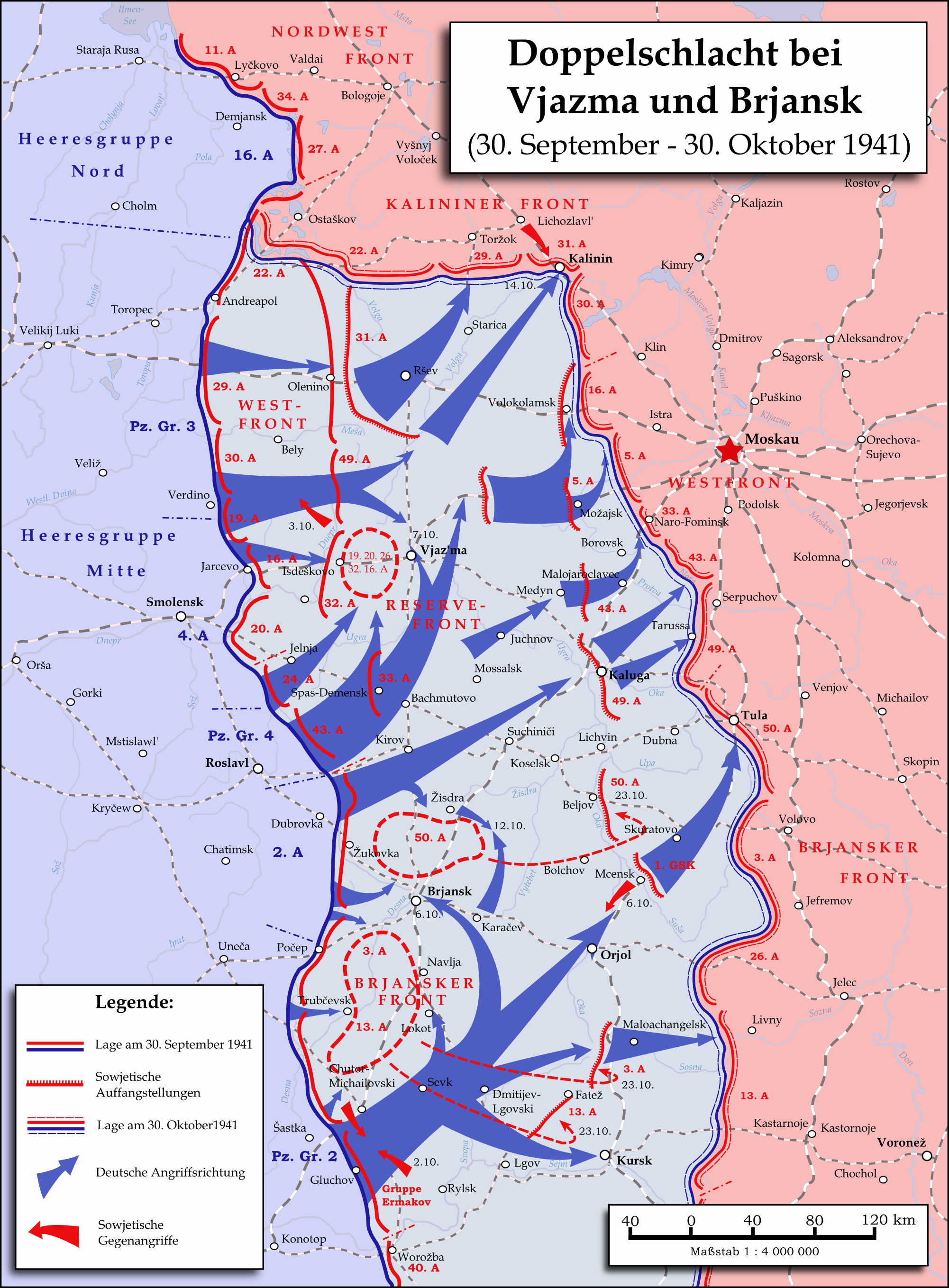
English: Map showing the two battles near Vyazma (October 2nd — October 20th 1941) and Brjansk (September 30th - October, 23rd) during the Second World War (1939—1945) at the Eastern Front. The map was created in Inkscape and is based on Map 30 in the attachment of the book P.N. Pospelow (Hrsg.): Geschichte des Großen Vaterländischen Krieges der Sowjetunion, Bd. 2, Berlin (Ost) 1963. The troop movements have been corrected.
Deutsch: Karte der Doppelschlacht im Raum Vjasma und Brjansk (30. September — 23. Oktober 1941) während des Zweiten Weltkrieges (1939—1945) an der Ostfront. Die Karte wurde mit Inkscape erstellt und basiert auf Karte Nr. 30 aus dem Anhang des Buches P.N. Pospelow (Hrsg.): Geschichte des Großen Vaterländischen Krieges der Sowjetunion, Bd. 2, Berlin (Ost) 1963. Die Truppenbewegungen wurden jedoch korrigiert. |
| Datum | |
| Bron | Eigen werk |
| Auteur | Memnon335bc |
Licentie
Ik, de auteursrechthebbende van dit werk, maak het hierbij onder de volgende licentie beschikbaar:
Dit bestand is gelicenseerd onder de Creative Commons-licentie Naamsvermelding 3.0 Unported
- De gebruiker mag:
- Delen – het werk kopiëren, verspreiden en doorgeven
- Remixen – afgeleide werken maken
- Onder de volgende voorwaarden:
- naamsvermelding – U moet op een gepaste manier aan naamsvermelding doen, een link naar de licentie geven, en aangeven of er wijzigingen in het werk zijn aangebracht. U mag dit op elke redelijke manier doen, maar niet zodanig dat de indruk wordt gewekt dat de licentiegever instemt met uw werk of uw gebruik van zijn werk.
Bestandsgeschiedenis
Klik op een datum/tijd om het bestand te zien zoals het destijds was.
| Datum/tijd | Miniatuur | Afmetingen | Gebruiker | Opmerking | |
|---|---|---|---|---|---|
| huidige versie | 1 jun 2015 00:06 | | 2.002 × 2.718 (1,56 MB) | Cmdrjameson | Compressed with pngout. Reduced by 600kB (27% decrease). |
| 18 sep 2009 14:01 |  | 2.002 × 2.718 (2,15 MB) | Memnon335bc | {{Information |Description={{en|1=Map showing the Twin-Battlea near Vyazma (October 2nd — October 20th 1941) and Brjansk (September 30th - Octpber, 23rd) during the Second World War (1939—1945) at the Eastern Front. The map is created by Inkscape and |
Bestandsgebruik
Dit bestand wordt op de volgende 2 pagina's gebruikt:
Globaal bestandsgebruik
De volgende andere wiki's gebruiken dit bestand:
- Gebruikt op azb.wikipedia.org
- Gebruikt op az.wikipedia.org
- Gebruikt op ba.wikipedia.org
- Gebruikt op be.wikipedia.org
- Gebruikt op de.wikipedia.org
- Gebruikt op en.wikipedia.org
- Gebruikt op es.wikipedia.org
- Gebruikt op et.wikipedia.org
- Gebruikt op fr.wikipedia.org
- Gebruikt op it.wikipedia.org
- Gebruikt op ja.wikipedia.org
- Gebruikt op pl.wikipedia.org
- Gebruikt op pt.wikipedia.org
- Gebruikt op ru.wikipedia.org
- Gebruikt op sl.wikipedia.org
- Gebruikt op th.wikipedia.org
- Gebruikt op tr.wikipedia.org
- Gebruikt op tt.wikipedia.org
- Gebruikt op vi.wikipedia.org
- Gebruikt op zh.wikipedia.org