Bestand:Josephinische Landaufnahme pg157.jpg

Grootte van deze voorvertoning: 800 × 536 pixels. Andere resoluties: 320 × 214 pixels | 640 × 429 pixels | 1.024 × 686 pixels | 1.280 × 858 pixels | 2.560 × 1.716 pixels | 8.368 × 5.608 pixels.
Oorspronkelijk bestand (8.368 × 5.608 pixels, bestandsgrootte: 23,64 MB, MIME-type: image/jpeg)
| Dit is een bestand van Wikimedia Commons. Onderstaande beschrijving komt van de beschrijving van het bestand daar. |
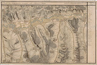
| Name shown on the map Nume din hartă |
Administrative unit Unitate administrativă |
Romanian name Numele românesc |
Hungarian name Numele unguresc |
German name Numele german |
Country today Ţara de astăzi |
|---|---|---|---|---|---|
| Erdõ Allya | Küküllõ megye Komitat Kokelburg Comitatul Târnava |
Sub Pădure | Erdõalja | Unterwald, Thalenberg | Romania |
| Potfalva | Küküllõ megye | Păucişoara | Küküllõpócsfalva | Poschendorf, Potschendorf, Puschendorf | Romania |
| Szõkefalva | Küküllõ megye | Seuca | Szõkefalva | Dunkeldorf | Romania |
| Galfalva | Küküllõ megye | Găneşti | Vámosgálfalva | Gallendorf, Hahnendorf, Hannendorf | Romania |
| Abosfalva | Küküllõ megye | Abuş | Abosfalva | Absdorf, Abtsdorf, Abuss | Romania |
| Desfalva | Küküllõ megye | Deaj | Désfalva | Desendorf | Romania |
| Futak | Küküllõ megye | Şomoştelnic | Somostelke | Futak, Somosdorf | Romania |
| Mikefalva | Küküllõ megye | Mica | Mikefalva | Michelsdorf | Romania |
| Felso Kapolna | Küküllõ megye | Căpâlna de Sus | Felsõkápolna | Kappeln | Romania |
| Bernad | Küküllõ megye | Bernadea | Bernád | Bernhardsdorf, Bernhardt | Romania |
| Hederfaja | Küküllõ megye | Idrifaia | Héderfája | Ederholz, Ederhulz, Ederhultz, Hidrigscholln | Romania |
| Szász Csávás | Küküllõ megye | Ceuaş | Csávás | Grubendorf | Romania |
| Bonyha | Küküllõ megye | Bahnea | Bonyha, Szászbonyha | Bachnen, Bachen | Romania |
| Szeplak | Küküllõ megye | Suplac | Küküllõszéplak | Schöndorf | Romania |
| Oláh Szent László | Küküllõ megye | Laslău Mare | Oláhszentlászló | Wallachisch-Lasseln, Laslen | Romania |
| Szász Örmenyes | Küküllõ megye | Ormeniş | Szászörményes | Irmesch, Urmesch | Romania |
| Gogany Várallya | Küküllõ megye | Gogan Varolea | Gógánváralja | Gogeschburg, Unter der Burg | Romania |
| Gogány | Küküllõ megye | Gogan | Gógán | Gugendorf, Gergendorf, Gogeschdorf | Romania |
| Leppend | Küküllõ megye | Lepindea | Leppend | Romania | |
| Danya | Küküllõ megye | Daia | Dányán | Denghel, Dengel | Romania |
| Harangláb | Küküllõ megye | Hărănglab | Harangláb | Glockendorf | Romania |
| Bogáts v Bögendorf | Medgyes szék (Zwei Stühle) Mediascher Stuhl Schelker Stuhl (Două Scaune) Scaunul Mediaşului Scaunul Şeica |
Băgaciu | Szászbogács | Bogeschdorf, Bogistorf [in Weinland, Köigsboden] | Romania |
| Kis Saros | Küküllõ megye | Delenii | Magyarsáros | Kleinfarken, Kleinferken, Schärschken | Romania |
Beschrijving
| Beschrijving |
Deutsch: Großfürstentum Siebenbürgen, 1769-1773. Josephinische Landaufnahme, Seite 157
English: Grand Duchy of Transylvania, 1769-1773. Josephinische Landaufnahme, page 157
Română: Harta Iosefină a Transilvaniei, 1769-1773. Josephinische Landaufnahme pg.157 |
||||
| Datum | tussen 1769 en 1773 | ||||
| Bron | Österreichisches Staatsarchiv, Kriegsarchiv, B IX 715: Original-Aufnahmskarte des Grossfürtenthums Siebenbürgen. Geometrisch aufgenommen und bearbeitet in den Jahren 1769 bis 1773 unter der Direction des Obristen von Fabris, theils durch Officiere des grossen Feld-Generalstabes, theils auch von verschiedenen aus dem in Siebenbürgen bequartierten Regimentern zu diesem Geschäfte beigezogenen Individuen | ||||
| Auteur | Historische Militärkarte der österreichisch-ungarischen Monarchie | ||||
| Toestemming (Hergebruik van dit bestand) |
|
||||
| Andere versies | Afgeleide werken van dit bestand: Szászcsávás-1770.jpg | ||||
Clickable Map of the Grand Duchy of Transylvania
Bestandsgeschiedenis
Klik op een datum/tijd om het bestand te zien zoals het destijds was.
| Datum/tijd | Miniatuur | Afmetingen | Gebruiker | Opmerking | |
|---|---|---|---|---|---|
| huidige versie | 8 dec 2009 09:07 | | 8.368 × 5.608 (23,64 MB) | Asybaris01 | good rezolution |
| 4 nov 2009 09:36 |  | 5.439 × 3.645 (16,38 MB) | Asybaris01 | {{Information |Description={{ro|1=Josephinische Landaufnahme pg157}} |Source=Josephinische Landaufnahme pg157 |Author=Asybaris01 |Date=2009/11/04 |Permission= |other_versions= }} |
Bestandsgebruik
Dit bestand wordt op de volgende pagina gebruikt:
Globaal bestandsgebruik
De volgende andere wiki's gebruiken dit bestand:
- Gebruikt op arz.wikipedia.org
- Gebruikt op en.wikipedia.org
- Gebruikt op hu.wikipedia.org
- Gebruikt op ro.wikipedia.org
- Gănești, Mureș
- Mica, Mureș
- Abuș, Mureș
- Bahnea, Mureș
- Suplac, Mureș
- Idrifaia, Mureș
- Băgaciu, Mureș
- Bernadea, Mureș
- Căpâlna de Sus, Mureș
- Ceuaș, Mureș
- Daia (Bahnea), Mureș
- Deaj, Mureș
- Gogan, Mureș
- Hărănglab, Mureș
- Idiciu, Mureș
- Laslău Mare, Mureș
- Lepindea, Mureș
- Ormeniș, Mureș
- Păucișoara, Mureș
- Sub Pădure, Mureș
- Șomoștelnic, Mureș
- Viișoara, Mureș
- Seuca, Mureș
- Deleni (Băgaciu), Mureș
- Gebruikt op tt.wikipedia.org
- Gebruikt op www.wikidata.org
- Gebruikt op zh.wikipedia.org