Bestand:Japan satellite view with Kii Peninsula marked.png

Grootte van deze voorvertoning: 658 × 600 pixels. Andere resoluties: 263 × 240 pixels | 527 × 480 pixels | 843 × 768 pixels | 1.124 × 1.024 pixels | 1.557 × 1.419 pixels.
Oorspronkelijk bestand (1.557 × 1.419 pixels, bestandsgrootte: 1,26 MB, MIME-type: image/png)
| Dit is een bestand van Wikimedia Commons. Onderstaande beschrijving komt van de beschrijving van het bestand daar. |
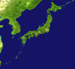
| Beschrijving | Satellite view of Japan with the Kii Peninsula marked. |
| Datum | |
| Bron |
|
| Auteur |
|
| Andere versies | Afgeleide werken van dit bestand: Kikai location on japan map.jpg |
| Dit is een geretoucheerde foto, wat betekent dat de originele versie digitaal aangepast is. Het origineel kan hier bekeken worden: Japan satellite.jpg. Aanpassingen gedaan door Nihonjoe.
|
| Dit bestand bevindt zich in het publiek domein, omdat het gemaakt is door de NASA. In de reproductierichtlijnen van de NASA staat dat "NASA-materiaal niet beschermd wordt door auteursrecht, tenzij anders vermeld". | ||
 |
Waarschuwingen:
|
Oorspronkelijk uploadlogboek
This image is a derivative work of the following images:
- File:Japan_satellite.jpg licensed with PD-USGov-NASA
- 2005-08-19T08:04:26Z っ 1557x1419 (971852 Bytes) source: http://visibleearth.nasa.gov/images/2433/land_shallow_topo_21600.tif {{PD-USGov-NASA}}
Bestandsgeschiedenis
Klik op een datum/tijd om het bestand te zien zoals het destijds was.
| Datum/tijd | Miniatuur | Afmetingen | Gebruiker | Opmerking | |
|---|---|---|---|---|---|
| huidige versie | 16 apr 2009 07:35 | | 1.557 × 1.419 (1,26 MB) | Nihonjoe | {{Information |Description=Satellite view of Japan with the Kii Peninsula marked. |Source=*Japan_satellite.jpg based on [http://visibleearth.nasa.gov/images/2433/land_shallow_topo_21600.tif this image] |
Bestandsgebruik
Dit bestand wordt op de volgende pagina gebruikt:
Globaal bestandsgebruik
De volgende andere wiki's gebruiken dit bestand:
- Gebruikt op ar.wikipedia.org
- Gebruikt op az.wikipedia.org
- Gebruikt op eu.wikipedia.org
- Gebruikt op hr.wikipedia.org
- Gebruikt op id.wikipedia.org
- Gebruikt op it.wikipedia.org
- Gebruikt op ko.wikipedia.org
- Gebruikt op ru.wikipedia.org
- Gebruikt op tr.wikipedia.org
- Gebruikt op www.wikidata.org