Bestand:Itasy lake.jpg
Geen hogere resolutie beschikbaar.
Itasy_lake.jpg (268 × 178 pixels, bestandsgrootte: 16 kB, MIME-type: image/jpeg)
| Dit is een bestand van Wikimedia Commons. Onderstaande beschrijving komt van de beschrijving van het bestand daar. |
Beschrijving
| Beschrijving |
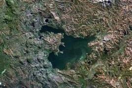
English: The Itasy volcanic field in central Madagascar.
|
| Datum | Datum onbekend |
| Bron | http://www.volcano.si.edu/world/volcano.cfm?vnum=0303-014&volpage=photos&photo=114074 |
| Auteur | NASA Landsat7 image (worldwind.arc.nasa.gov) |
| Andere versies |

Licentie
| Deze afbeelding bevindt zich in het publiek domein omdat het een screenshot is van NASA’s software World Wind die gebruik maakt van een publiek domein-laag, zoals Blue Marble, MODIS, Landsat, SRTM, USGS of GLOBE.
|
 |
Bestandsgeschiedenis
Klik op een datum/tijd om het bestand te zien zoals het destijds was.
| Datum/tijd | Miniatuur | Afmetingen | Gebruiker | Opmerking | |
|---|---|---|---|---|---|
| huidige versie | 1 feb 2022 11:47 | | 268 × 178 (16 kB) | Proeksad | File:Itasy Volcanic Field.jpg cropped 58 % horizontally, 58 % vertically using CropTool with precise mode. |
Bestandsgebruik
Dit bestand wordt op de volgende pagina gebruikt:
Globaal bestandsgebruik
De volgende andere wiki's gebruiken dit bestand:
- Gebruikt op ceb.wikipedia.org
- Gebruikt op en.wikipedia.org
- Gebruikt op fr.wikipedia.org
- Gebruikt op hr.wikipedia.org
- Gebruikt op mg.wikipedia.org
- Gebruikt op ru.wikipedia.org
- Gebruikt op sl.wikipedia.org
- Gebruikt op www.wikidata.org