Bestand:Israel and the Disputed Territories map.png

Oorspronkelijk bestand (1.350 × 2.300 pixels, bestandsgrootte: 1,39 MB, MIME-type: image/png)
| Dit is een bestand van Wikimedia Commons. Onderstaande beschrijving komt van de beschrijving van het bestand daar. |
Beschrijving
| Beschrijving |
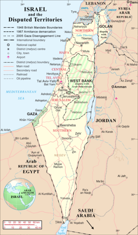
English: Map of Israel, Palestinian Controlled Territories of (Gaza and the West Bank), the Golan Heights, and neighbouring countries. Also United Nations deployment, as of January 2004, in the area. |
|||
| Datum | ||||
| Bron | http://www.un.org/Depts/Cartographic/map/profile/israel.pdf (heavily modified) | |||
| Auteur | Jaakobou | |||
| Toestemming (Hergebruik van dit bestand) |
|

| Aantekeningen | Deze afbeelding is aangetekend: Bekijk de aantekeningen op Commons |
Bestandsgeschiedenis
Klik op een datum/tijd om het bestand te zien zoals het destijds was.
| Datum/tijd | Miniatuur | Afmetingen | Gebruiker | Opmerking | |
|---|---|---|---|---|---|
| huidige versie | 1 apr 2007 20:03 | | 1.350 × 2.300 (1,39 MB) | Jaakobou | == Summary == {{Information |Description= {{en|Map of Israel, [http://en.wikipedia.org/wiki/Palestinian_territories Palestinian Controlled Territories of] (Gaza and the West Bank), the Golan Heights, and neighbouring countries. |
Bestandsgebruik
Dit bestand wordt op de volgende pagina gebruikt:
Globaal bestandsgebruik
De volgende andere wiki's gebruiken dit bestand:
- Gebruikt op ar.wikipedia.org
- Gebruikt op de.wikinews.org
- Gebruikt op en.wikipedia.org
- Gebruikt op he.wikipedia.org
- Gebruikt op sq.wikipedia.org
- Gebruikt op uk.wikipedia.org
- Gebruikt op zea.wikipedia.org