Bestand:Intercitynet NL 2012.png

Grootte van deze voorvertoning: 507 × 599 pixels. Andere resoluties: 203 × 240 pixels | 406 × 480 pixels | 650 × 768 pixels | 866 × 1.024 pixels | 1.686 × 1.993 pixels.
Oorspronkelijk bestand (1.686 × 1.993 pixels, bestandsgrootte: 128 kB, MIME-type: image/png)
| Dit is een bestand van Wikimedia Commons. Onderstaande beschrijving komt van de beschrijving van het bestand daar. |
Beschrijving
| Beschrijving |
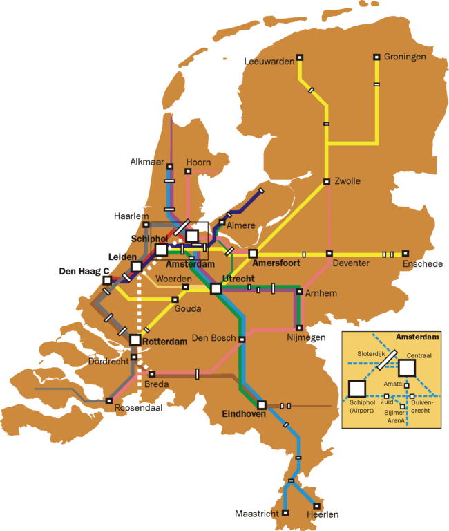
English: Map of the Dutch Intercity network. Thin lines are used for all-stops services that are a continuation of intercity services (e.g. the Rotterdam-Gouda-Amsterdam leg of the Enkhuizen-Rotterdam trains, and the Roosendaal - Vlissingen leg of the Amsterdam-Vlissingen trains).
Further notes:
|
| Datum | |
| Bron | Eigen werk |
| Auteur | Classical geographer |
Licentie
Ik, de auteursrechthebbende van dit werk, maak het hierbij onder de volgende licenties beschikbaar:
Dit bestand is gelicenseerd onder de Creative Commons-licentie Naamsvermelding-Gelijk delen 3.0 Unported
- De gebruiker mag:
- Delen – het werk kopiëren, verspreiden en doorgeven
- Remixen – afgeleide werken maken
- Onder de volgende voorwaarden:
- naamsvermelding – U moet op een gepaste manier aan naamsvermelding doen, een link naar de licentie geven, en aangeven of er wijzigingen in het werk zijn aangebracht. U mag dit op elke redelijke manier doen, maar niet zodanig dat de indruk wordt gewekt dat de licentiegever instemt met uw werk of uw gebruik van zijn werk.
- Gelijk delen – Als u het werk heeft geremixt, veranderd, of erop heeft voortgebouwd, moet u het gewijzigde materiaal verspreiden onder dezelfde licentie als het oorspronkelijke werk, of een daarmee compatibele licentie.

|
Toestemming wordt verleend voor het kopiëren, verspreiden en/of wijzigen van dit document onder de voorwaarden van de GNU-licentie voor vrije documentatie, versie 1.2 of enige latere versie als gepubliceerd door de Free Software Foundation; zonder Invariant Sections, zonder Front-Cover Texts, en zonder Back-Cover Texts. Een kopie van de licentie is opgenomen in de sectie GNU-licentie voor vrije documentatie. |
U mag zelf één van de licenties kiezen.
Bestandsgeschiedenis
Klik op een datum/tijd om het bestand te zien zoals het destijds was.
| Datum/tijd | Miniatuur | Afmetingen | Gebruiker | Opmerking | |
|---|---|---|---|---|---|
| huidige versie | 11 jan 2012 21:44 | | 1.686 × 1.993 (128 kB) | Classical geographer | Now uploaded correct version, indeed without Best. |
| 14 nov 2011 21:03 |  | 1.686 × 1.993 (128 kB) | Classical geographer | Added Delft and Schiedam, removed Best. | |
| 5 aug 2011 19:37 |  | 1.686 × 1.993 (523 kB) | Classical geographer | Updated to 2012. | |
| 5 aug 2011 19:36 |  | 4.216 × 4.984 (439 kB) | Classical geographer | Updated to 2012. | |
| 16 okt 2009 16:57 |  | 2.810 × 3.323 (610 kB) | T n g old commons | De intercity naar venlo rijdt pas na Deurne als stoptrein. Na eindhoven skipt hij nog de stations Helmond Brandevoort en Helmond 't Hout, waarnaar de intercity stopt op station helmond, en daarna weer station Brouwhuis skipt, dan stopt hij op deurne, wat | |
| 12 mrt 2009 18:45 |  | 2.810 × 3.323 (511 kB) | Classical geographer | {{Information |Description={{en|1=Map of the Dutch Intercity network. Narrower lines are intercities that run an all-stops service. (On the Rotterdam-Gouda-Amsterdam line, the intercity is even officially called Stoptrein, but it is still indicated here.) |
Bestandsgebruik
Dit bestand wordt op de volgende pagina gebruikt:
Globaal bestandsgebruik
De volgende andere wiki's gebruiken dit bestand:
- Gebruikt op ja.wikipedia.org