Bestand:Iditarod Trail BLM map.jpg
Geen hogere resolutie beschikbaar.
Iditarod_Trail_BLM_map.jpg (759 × 576 pixels, bestandsgrootte: 85 kB, MIME-type: image/jpeg)
| Dit is een bestand van Wikimedia Commons. Onderstaande beschrijving komt van de beschrijving van het bestand daar. |
Beschrijving
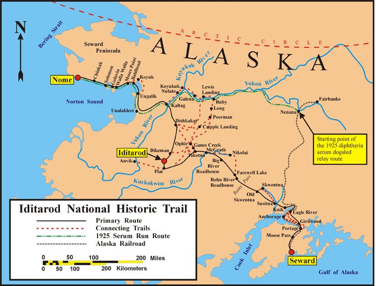
| Beschrijving | Map of the historical Iditarod Trail and the current Iditarod National Historic Trail in Alaska, USA |
| Datum | |
| Bron | U.S. Bureau of Land Management |
| Auteur | U.S. Bureau of Land Management |
| Toestemming (Hergebruik van dit bestand) |
public domain, as a U.S. federal government work |

|
Deze kaartafbeelding zou opnieuw moeten worden aangemaakt als een SVG-bestand door vectorafbeeldingen te gebruiken. Dit heeft een aantal voordelen; zie Commons:Media for cleanup voor meer informatie. Als er een SVG-formaat van deze afbeelding bestaat, dan deze graag uploaden. Nadat u dit heeft gedaan, gelieve dit sjabloon te vervangen door het sjabloon {{vector version available|nieuwe bestandsnaam.svg}} op deze afbeeldingspagina.
|


Licentie
| This image is a work of a Bureau of Land Management* employee, taken or made as part of that person's official duties. As a work of the U.S. federal government, the image is in the public domain in the United States. *or predecessor organization |
Bestandsgeschiedenis
Klik op een datum/tijd om het bestand te zien zoals het destijds was.
| Datum/tijd | Miniatuur | Afmetingen | Gebruiker | Opmerking | |
|---|---|---|---|---|---|
| huidige versie | 9 feb 2008 07:47 | | 759 × 576 (85 kB) | Delirium | {{Information |Description=Map of the historical Iditarod Trail and the current Iditarod National Historic Trail in Alaska, USA |Source=[http://www.blm.gov/ak/st/en/prog/sa/iditarod/inht_map.html U.S. Bureau of Land Management] |Date=2007 |Author=U.S. Bur |
Bestandsgebruik
Dit bestand wordt op de volgende pagina gebruikt:
Globaal bestandsgebruik
De volgende andere wiki's gebruiken dit bestand:
- Gebruikt op az.wikipedia.org
- Gebruikt op cs.wikipedia.org
- Gebruikt op de.wikipedia.org
- Gebruikt op en.wikipedia.org
- Gebruikt op en.wikivoyage.org
- Gebruikt op es.wikipedia.org
- Gebruikt op fr.wikipedia.org
- Iditarod Trail
- Course au sérum de 1925
- Discussion:Course au sérum de 1925
- Wikipédia:Le saviez-vous ?/Archives/2015
- Utilisateur:GhosterBot/BacASable/testStat/Visibilité des anecdotes (2015)
- Utilisateur:GhosterBot/BacASable/testStat/Visibilité des anecdotes (2015)/2015 02
- Wikipédia:Statistiques des anecdotes de la page d'accueil/Visibilité des anecdotes (2015)/2015 02
- Wikipédia:Statistiques des anecdotes de la page d'accueil/Visibilité des anecdotes (2015)
- Discussion:Course au sérum de 1925/LSV 16741
- Gebruikt op he.wikipedia.org
- Gebruikt op id.wikipedia.org
- Gebruikt op it.wikipedia.org
- Gebruikt op ms.wikipedia.org
- Gebruikt op pl.wikipedia.org
- Gebruikt op ru.wikipedia.org
- Gebruikt op simple.wikipedia.org
- Gebruikt op uk.wikipedia.org
- Gebruikt op vi.wikipedia.org
- Gebruikt op www.wikidata.org
- Gebruikt op zh.wikipedia.org