Bestand:Iberian Union Empires.png
Grootte van deze voorvertoning: 800 × 370 pixels. Andere resoluties: 320 × 148 pixels | 640 × 296 pixels | 1.357 × 628 pixels.
Oorspronkelijk bestand (1.357 × 628 pixels, bestandsgrootte: 25 kB, MIME-type: image/png)
| Dit is een bestand van Wikimedia Commons. Onderstaande beschrijving komt van de beschrijving van het bestand daar. |


|
Bestand:Iberian Union empires.svg is een vectorversie van dit bestand. Indien niet van slechtere kwaliteit dient deze gebruikt te worden in plaats van deze rasterafbeelding.
File:Iberian Union Empires.png → File:Iberian Union empires.svg
Zie Help:SVG voor meer informatie. |
 |
| Beschrijving |
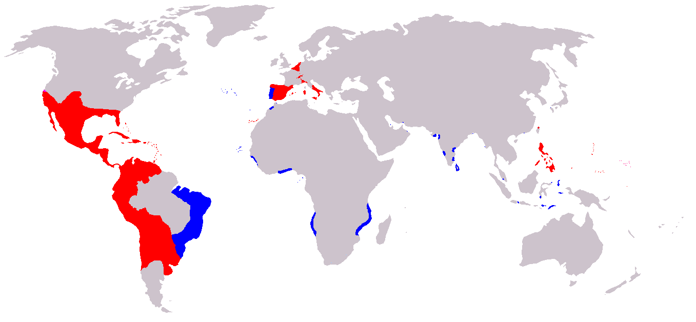
A map of the Spanish and Portuguese Empires in the period of their personal union (1581-1640). Blue: Portuguese Empire; Red: Spanish Empire; |
||
| Bron | English Wikipedia, original description is/was here. | ||
| Auteur | en:User:Câmara | ||
| Toestemming (Hergebruik van dit bestand) |
|
Bestandsgeschiedenis
Klik op een datum/tijd om het bestand te zien zoals het destijds was.
| Datum/tijd | Miniatuur | Afmetingen | Gebruiker | Opmerking | |
|---|---|---|---|---|---|
| huidige versie | 20 nov 2019 09:00 | | 1.357 × 628 (25 kB) | Geographyinitiative | Added Spanish Formosa |
| 4 jan 2009 17:05 |  | 1.357 × 628 (22 kB) | The Red Hat of Pat Ferrick | Trim size of Portuguese colonies, remove "claims" areas. | |
| 12 jul 2007 18:32 |  | 1.357 × 628 (38 kB) | Gveret Tered | {{Information |Description==A map of the Spanish and Portuguese Empires in the period of their personal union (1581-1640). == Licensing ==. |Source=[http://en.wikipedia.org English Wikipedia], original description is/was [[:en:Image:Iberian Union Empires. |
Bestandsgebruik
Dit bestand wordt op de volgende 4 pagina's gebruikt:
Globaal bestandsgebruik
De volgende andere wiki's gebruiken dit bestand:
- Gebruikt op ar.wikipedia.org
- Gebruikt op ast.wikipedia.org
- Gebruikt op azb.wikipedia.org
- Gebruikt op be.wikipedia.org
- Gebruikt op ca.wikipedia.org
- Gebruikt op cs.wikipedia.org
- Gebruikt op da.wikipedia.org
- Gebruikt op de.wikipedia.org
- Gebruikt op en.wikipedia.org
- Gebruikt op es.wikipedia.org
- Gebruikt op fa.wikipedia.org
- Gebruikt op fr.wikipedia.org
- Gebruikt op gl.wikipedia.org
- Gebruikt op he.wikipedia.org
- Gebruikt op hu.wikipedia.org
- Gebruikt op io.wikipedia.org
- Gebruikt op it.wikipedia.org
- Gebruikt op ja.wikipedia.org
Globaal gebruik van dit bestand bekijken.