Bestand:Hampshire UK locator map 2010.svg

Afmetingen van deze voorvertoning van het type PNG van dit SVG-bestand: 494 × 600 pixels Andere resoluties: 198 × 240 pixels | 395 × 480 pixels | 633 × 768 pixels | 843 × 1.024 pixels | 1.687 × 2.048 pixels | 1.108 × 1.345 pixels.
Oorspronkelijk bestand (SVG-bestand, nominaal 1.108 × 1.345 pixels, bestandsgrootte: 302 kB)
Dit is een bestand van Wikimedia Commons.
Onderstaande beschrijving komt van de beschrijving van het bestand daar.
Onderstaande beschrijving komt van de beschrijving van het bestand daar.
Beschrijving
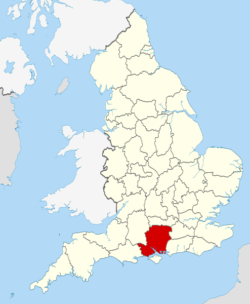
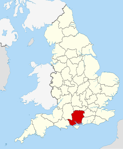
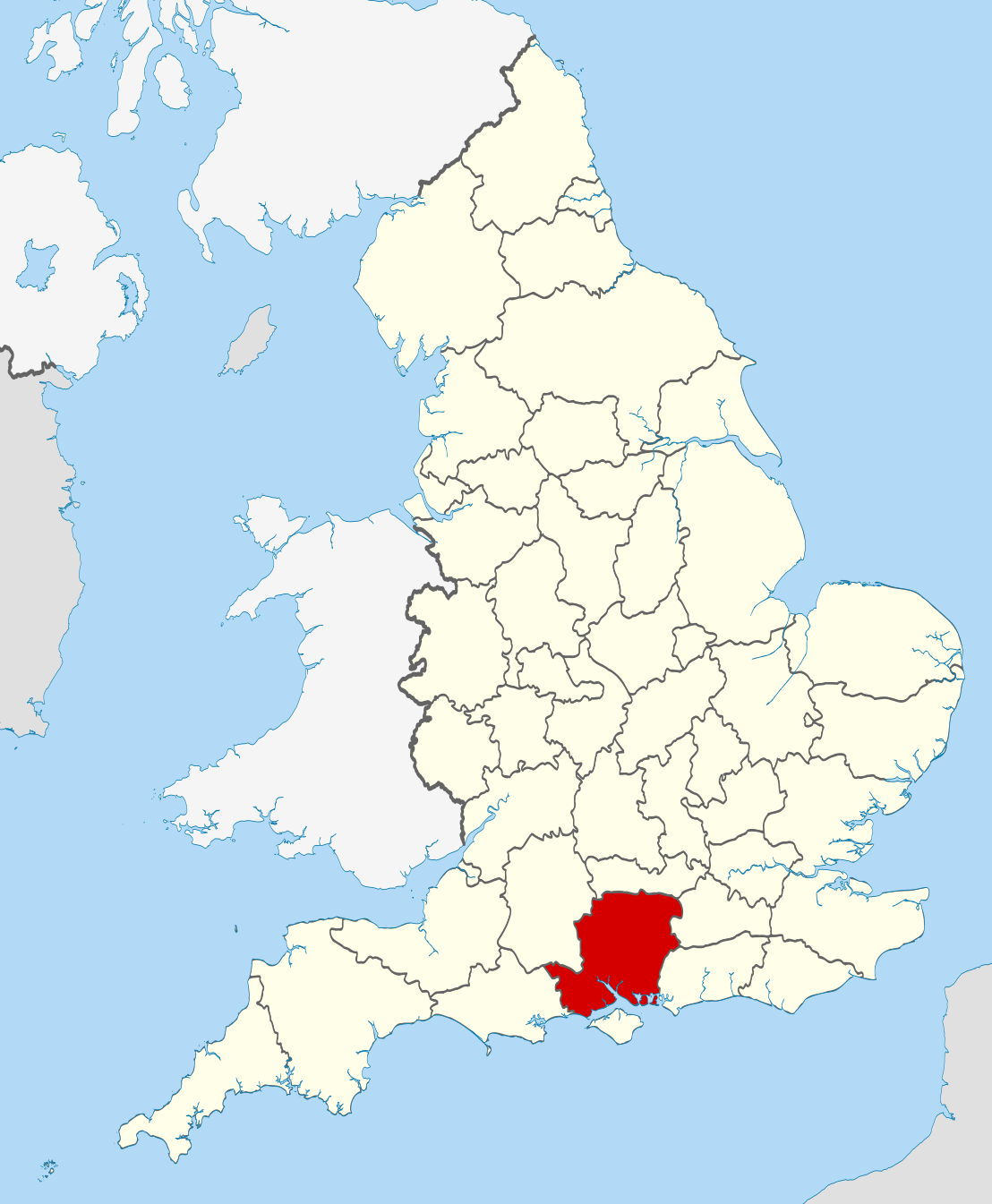
| Beschrijving | Location of the ceremonial county of Hampshire within England. |
| Datum | |
| Bron |
National Geospatial-Intelligence Agency
|
| Auteur | Nilfanion |
Licentie
Ik, de auteursrechthebbende van dit werk, maak het hierbij onder de volgende licenties beschikbaar:
Dit bestand is gelicenseerd onder de Creative Commons-licentie Naamsvermelding-Gelijk delen 3.0 Unported
- De gebruiker mag:
- Delen – het werk kopiëren, verspreiden en doorgeven
- Remixen – afgeleide werken maken
- Onder de volgende voorwaarden:
- naamsvermelding – U moet op een gepaste manier aan naamsvermelding doen, een link naar de licentie geven, en aangeven of er wijzigingen in het werk zijn aangebracht. U mag dit op elke redelijke manier doen, maar niet zodanig dat de indruk wordt gewekt dat de licentiegever instemt met uw werk of uw gebruik van zijn werk.
- Gelijk delen – Als u het werk heeft geremixt, veranderd, of erop heeft voortgebouwd, moet u het gewijzigde materiaal verspreiden onder dezelfde licentie als het oorspronkelijke werk, of een daarmee compatibele licentie.

|
Toestemming wordt verleend voor het kopiëren, verspreiden en/of wijzigen van dit document onder de voorwaarden van de GNU-licentie voor vrije documentatie, versie 1.2 of enige latere versie als gepubliceerd door de Free Software Foundation; zonder Invariant Sections, zonder Front-Cover Texts, en zonder Back-Cover Texts. Een kopie van de licentie is opgenomen in de sectie GNU-licentie voor vrije documentatie. |
U mag zelf één van de licenties kiezen.

|
Dit is een van de afbeeldingen die deel uitmaken van de set Gewaardeerde afbeeldingen: Locator maps of the Ceremonial counties of England op Wikimedia Commons. De afbeeldingen zijn beoordeeld volgens de criteria daarvoor en de set wordt beschouwd als de meest waardevolle op Commons op dat bepaalde gebied:
Locator maps of the Ceremonial counties of England
U kunt de nominatie zien op Commons:Valued image candidates/Locator maps of English ceremonial counties. |
Bestandsgeschiedenis
Klik op een datum/tijd om het bestand te zien zoals het destijds was.
| Datum/tijd | Miniatuur | Afmetingen | Gebruiker | Opmerking | |
|---|---|---|---|---|---|
| huidige versie | 24 nov 2010 00:37 | | 1.108 × 1.345 (302 kB) | Nilfanion | == Summary == {{Information |Description=Location of the ceremonial county of Hampshire within England. |Source=Ordnance Survey [https://www.ordnancesurvey.co.uk/opendatadownload/products.html OpenData]: *County bound |
Bestandsgebruik
Dit bestand wordt op de volgende pagina gebruikt:
Globaal bestandsgebruik
De volgende andere wiki's gebruiken dit bestand:
- Gebruikt op af.wikipedia.org
- Gebruikt op ar.wikipedia.org
- Gebruikt op ast.wikipedia.org
- Gebruikt op be-tarask.wikipedia.org
- Gebruikt op bg.wikipedia.org
- Gebruikt op ca.wikipedia.org
- Gebruikt op ceb.wikipedia.org
- Gebruikt op cs.wikipedia.org
- Gebruikt op dag.wikipedia.org
- Gebruikt op en.wikipedia.org
- Hampshire
- Lovedean
- Bramdean Common
- Matley Bog
- Spithead
- Mengham
- Tourner Bury
- Hill Head
- Fratton
- Appleshaw
- Hart Plain
- Coombe, Hampshire
- Easton, Hampshire
- Freefolk
- Turgis Green
- Hambledon, Hampshire
- Avon Valley Path
- Clarendon Way
- King's Way
- Pilgrims' Trail
- Bentley, Hampshire
- Hangers Way
- Three Castles Path
- Soberton and Newtown Millennium Walk 2000
- Sutton Scotney
- Castleman Trailway
- Blackwater Valley Path
- Pilot Hill, Hampshire
- Queen Elizabeth Country Park
- North Waltham
- Cliddesden
- Baybridge, Hampshire
- Farther Common
- Lychpit
- Spanish Green
- Template:Hampshire-geo-stub
- Abbots Worthy
- Litchfield, Hampshire
- Tipner
Globaal gebruik van dit bestand bekijken.