Bestand:Gulf of Taranto map.png

Grootte van deze voorvertoning: 545 × 600 pixels. Andere resoluties: 218 × 240 pixels | 436 × 480 pixels | 698 × 768 pixels | 1.200 × 1.321 pixels.
Oorspronkelijk bestand (1.200 × 1.321 pixels, bestandsgrootte: 348 kB, MIME-type: image/png)
| Dit is een bestand van Wikimedia Commons. Onderstaande beschrijving komt van de beschrijving van het bestand daar. |
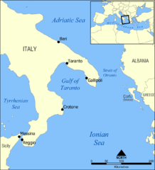
A map showing the location of the Gulf of Taranto in the Mediterranean sea, south of Italy.
Created by NormanEinstein, March 28, 2006.
Ik, de auteursrechthebbende van dit werk, maak het hierbij onder de volgende licentie beschikbaar:

|
Toestemming wordt verleend voor het kopiëren, verspreiden en/of wijzigen van dit document onder de voorwaarden van de GNU-licentie voor vrije documentatie, versie 1.2 of enige latere versie als gepubliceerd door de Free Software Foundation; zonder Invariant Sections, zonder Front-Cover Texts, en zonder Back-Cover Texts. Een kopie van de licentie is opgenomen in de sectie GNU-licentie voor vrije documentatie. |
| Dit bestand is gelicenseerd onder de Creative Commons-licentie Naamsvermelding-Gelijk delen 3.0 Unported | ||
| ||
| Deze licentietag is toegevoegd aan dit bestand in verband met de GFDL licentie-update. |
Other versions
- Croatian: File:Gulf of Taranto map hr.svg
Bestandsgeschiedenis
Klik op een datum/tijd om het bestand te zien zoals het destijds was.
| Datum/tijd | Miniatuur | Afmetingen | Gebruiker | Opmerking | |
|---|---|---|---|---|---|
| huidige versie | 3 jun 2009 16:35 | | 1.200 × 1.321 (348 kB) | Rhegion | added Reggio |
| 28 mrt 2006 20:53 |  | 1.200 × 1.321 (409 kB) | NormanEinstein | A map showing the location of the Gulf of Taranto in the Mediterranean sea, south of Italy. Created by NormanEinstein, March 28, 2006. {{GFDL-self}} |
Bestandsgebruik
Dit bestand wordt op de volgende pagina gebruikt:
Globaal bestandsgebruik
De volgende andere wiki's gebruiken dit bestand:
- Gebruikt op ar.wikipedia.org
- Gebruikt op az.wikipedia.org
- Gebruikt op ba.wikipedia.org
- Gebruikt op be-tarask.wikipedia.org
- Gebruikt op be.wikipedia.org
- Gebruikt op br.wikipedia.org
- Gebruikt op bs.wikipedia.org
- Gebruikt op ckb.wikipedia.org
- Gebruikt op cs.wikipedia.org
- Gebruikt op da.wikipedia.org
- Gebruikt op de.wikipedia.org
- Gebruikt op de.wikibooks.org
- Gebruikt op el.wikipedia.org
- Gebruikt op en.wikipedia.org
- Tegetthoff-class battleship
- SMS Szent István
- Gulf of Taranto
- SMS Prinz Eugen (1912)
- User:NormanEinstein/gallery
- Adriatic campaign of 1807–1814
- Wikipedia:Graphics Lab/Map workshop/Archive/Feb 2012
- SMS Saida
- Yugoslav torpedo boat T4
- Novara-class cruiser
- SMS Tegetthoff (1912)
- SMS Admiral Spaun
- SMS Orjen
- Gebruikt op eo.wikipedia.org
- Gebruikt op es.wikipedia.org
- Gebruikt op eu.wikipedia.org
- Gebruikt op ext.wikipedia.org
- Gebruikt op fa.wikipedia.org
- Gebruikt op fi.wikipedia.org
- Gebruikt op fo.wikipedia.org
- Gebruikt op fr.wikipedia.org
- Gebruikt op gl.wikipedia.org
Globaal gebruik van dit bestand bekijken.