Bestand:Guiana shield map-fr.svg

Afmetingen van deze voorvertoning van het type PNG van dit SVG-bestand: 742 × 599 pixels Andere resoluties: 297 × 240 pixels | 594 × 480 pixels | 951 × 768 pixels | 1.268 × 1.024 pixels | 2.535 × 2.048 pixels | 3.123 × 2.523 pixels.
Oorspronkelijk bestand (SVG-bestand, nominaal 3.123 × 2.523 pixels, bestandsgrootte: 1,03 MB)
| Dit is een bestand van Wikimedia Commons. Onderstaande beschrijving komt van de beschrijving van het bestand daar. |
Beschrijving
| Beschrijving |
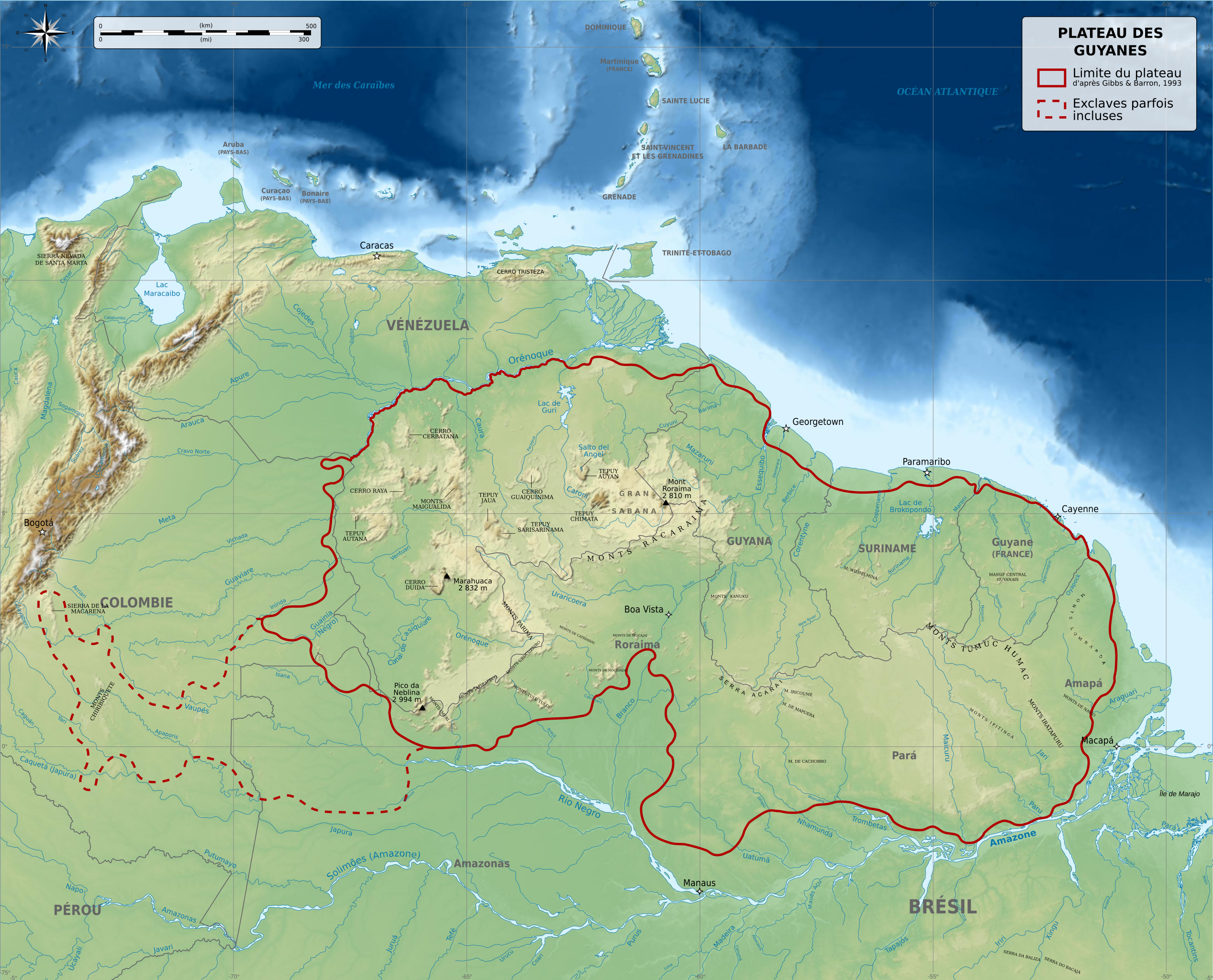
English: Physical map of Guiana Shield, a craton located in South America, between Brazil, French Guiana, Suriname, Guyana, Venezuela and Colombia. Français : Carte physique du plateau des Guyanes, un craton situé en Amérique du Sud, répartis entre le Brésil, la Guyane française, le Suriname, le Guyana, le Vénézuela et la Colombie. Македонски: Карта на Гвајанскиот Штит во Јужна Америка. |
||
| Datum | |||
| Bron |
Eigen werk. Source :
Additional data :
|
||
| Auteur | Sémhur (talk) | ||
| Andere versies |
Afgeleide werken van dit bestand: | ||
| Naamsvermelding (required by the license) | © Sémhur / Wikimedia Commons / | ||
| SVG | W3C-validity not checked. Deze niet W3C-verklaarde vectorafbeelding is gemaakt met Inkscape .
|
||
| Graphic Lab |


-es.svg)
-es.svg)
| Cameralocatie | | Deze en andere afbeeldingen in: OpenStreetMap |
|---|
Licentie
Ik, de auteursrechthebbende van dit werk, maak het hierbij onder de volgende licenties beschikbaar:
| Copyleft: dit kunstwerk is vrij; u mag het heruitgeven en/of wijzigen in overeenkomst met de voorwaarden van de Free Art-licentie.
U kunt een voorbeeld van de licentie vinden op de website van Copyleft Attitude als ook op andere websites. |
This file is licensed under the Creative Commons Attribution-Share Alike 4.0 International, 3.0 Unported, 2.5 Generic, 2.0 Generic and 1.0 Generic license.
- De gebruiker mag:
- Delen – het werk kopiëren, verspreiden en doorgeven
- Remixen – afgeleide werken maken
- Onder de volgende voorwaarden:
- naamsvermelding – U moet op een gepaste manier aan naamsvermelding doen, een link naar de licentie geven, en aangeven of er wijzigingen in het werk zijn aangebracht. U mag dit op elke redelijke manier doen, maar niet zodanig dat de indruk wordt gewekt dat de licentiegever instemt met uw werk of uw gebruik van zijn werk.
- Gelijk delen – Als u het werk heeft geremixt, veranderd, of erop heeft voortgebouwd, moet u het gewijzigde materiaal verspreiden onder dezelfde licentie als het oorspronkelijke werk, of een daarmee compatibele licentie.
U mag zelf één van de licenties kiezen.
Bestandsgeschiedenis
Klik op een datum/tijd om het bestand te zien zoals het destijds was.
| Datum/tijd | Miniatuur | Afmetingen | Gebruiker | Opmerking | |
|---|---|---|---|---|---|
| huidige versie | 27 mei 2014 08:49 | | 3.123 × 2.523 (1,03 MB) | Sémhur | Valid SVG |
| 5 dec 2010 23:53 |  | 3.123 × 2.523 (1,03 MB) | Sémhur | Mispelling : Mer ces Caraïbes => Mer des Caraïbes | |
| 3 dec 2010 20:57 |  | 3.123 × 2.523 (1,03 MB) | Sémhur | With the good size | |
| 3 dec 2010 20:55 |  | 512 × 414 (1,08 MB) | Sémhur | == {{int:filedesc}} == {{Information |Description={{Multilingual description |en= Physical map of Guiana Shield, a craton located in South America, between Brazil, French Guiana, Suriname, Guyana, Venezuela and Colombi |
Bestandsgebruik
Dit bestand wordt op de volgende pagina gebruikt:
Globaal bestandsgebruik
De volgende andere wiki's gebruiken dit bestand:
- Gebruikt op es.wikipedia.org
- Gebruikt op fr.wikipedia.org
- Gebruikt op gcr.wikipedia.org
- Gebruikt op it.wikipedia.org
- Gebruikt op ky.wikipedia.org
- Gebruikt op mn.wikipedia.org
- Gebruikt op oc.wiktionary.org