Bestand:Greater Accra districts.png

Grootte van deze voorvertoning: 800 × 560 pixels. Andere resoluties: 320 × 224 pixels | 640 × 448 pixels | 995 × 696 pixels.
Oorspronkelijk bestand (995 × 696 pixels, bestandsgrootte: 14 kB, MIME-type: image/png)
Dit is een bestand van Wikimedia Commons.
Onderstaande beschrijving komt van de beschrijving van het bestand daar.
Onderstaande beschrijving komt van de beschrijving van het bestand daar.
Beschrijving
| Beschrijving |
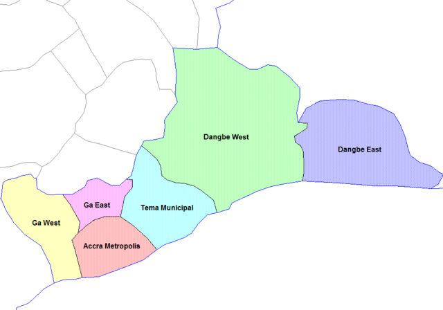
English: Map of the districts of the Greater Accra region of Ghana. Created by Rarelibra for public domain use. Created using MapInfo Professional v7.5 and various mapping resources. |
||
| Datum | 28 juni 2006 (originele uploaddatum) | ||
| Bron | Eigen werk | ||
| Auteur | User:Rarelibra | ||
| Andere versies |
|

Licentie
| Ik, de auteursrechthebbende van dit werk, geef dit werk vrij in het publieke domein. Dit is wereldwijd van toepassing. In sommige landen is dit wettelijk niet mogelijk; in die gevallen geldt: Ik sta iedereen toe dit werk voor eender welk doel te gebruiken, zonder enige voorwaarden, tenzij zulke voorwaarden door de wet worden voorgeschreven. |
Oorspronkelijk uploadlogboek
- (del) (cur) 07:36, 5 March 2006 . . Rarelibra (Talk | contribs) . . 1056x816 (29,321 bytes) (Map of the districts of the Greater Accra region of Ghana. Created by Rarelibra for public domain use. Created using MapInfo Professional v7.5 and various mapping resources.)
Bestandsgeschiedenis
Klik op een datum/tijd om het bestand te zien zoals het destijds was.
| Datum/tijd | Miniatuur | Afmetingen | Gebruiker | Opmerking | |
|---|---|---|---|---|---|
| huidige versie | 6 jan 2021 16:00 | | 995 × 696 (14 kB) | Jakob Gottfried | cropped |
| 28 jun 2006 12:52 |  | 1.056 × 816 (29 kB) | Ahanta | from:en:Districts of ghana Map of the districts of the Greater Accra region of Ghana. Created by Rarelibra for public domain use. Created using MapInfo Professional v7.5 and various mapping resources. [edit] I, the creator of this work, hereby release it |
Bestandsgebruik
Dit bestand wordt op de volgende 2 pagina's gebruikt:
Globaal bestandsgebruik
De volgende andere wiki's gebruiken dit bestand:
- Gebruikt op ceb.wikipedia.org
- Gebruikt op cs.wikipedia.org
- Gebruikt op dag.wikipedia.org
- Gebruikt op de.wikipedia.org
- Gebruikt op en.wikipedia.org
- Gebruikt op es.wikipedia.org
- Gebruikt op fr.wikipedia.org
- Gebruikt op gpe.wikipedia.org
- Gebruikt op it.wikipedia.org
- Gebruikt op ko.wikipedia.org
- Gebruikt op pl.wikipedia.org
- Gebruikt op pt.wikipedia.org
- Gebruikt op ro.wikipedia.org
- Gebruikt op tr.wikipedia.org
- Gebruikt op tw.wikipedia.org
- Gebruikt op uk.wikipedia.org
- Gebruikt op www.wikidata.org
- Gebruikt op yo.wikipedia.org
- Gebruikt op zu.wikipedia.org