Bestand:GoodenoughIslandTopography.png

Grootte van deze voorvertoning: 657 × 600 pixels. Andere resoluties: 263 × 240 pixels | 526 × 480 pixels | 841 × 768 pixels | 1.122 × 1.024 pixels | 1.398 × 1.276 pixels.
Oorspronkelijk bestand (1.398 × 1.276 pixels, bestandsgrootte: 312 kB, MIME-type: image/png)
Dit is een bestand van Wikimedia Commons.
Onderstaande beschrijving komt van de beschrijving van het bestand daar.
Onderstaande beschrijving komt van de beschrijving van het bestand daar.
Beschrijving
| Beschrijving |
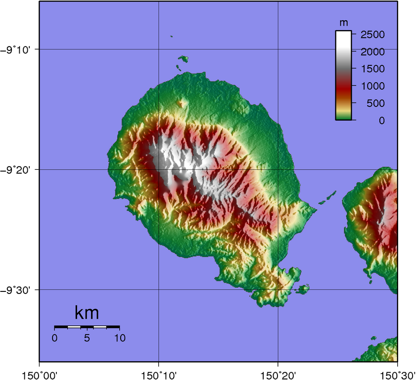
Topographic map of Goodenough Island SRTM data has lots missing data up in the mountains... |
| Datum | |
| Bron | Created with GMT from publicly available SRTM data |
| Auteur | Sadalmelik |
Licentie
| Ik, de auteursrechthebbende van dit werk, geef dit werk vrij in het publieke domein. Dit is wereldwijd van toepassing. In sommige landen is dit wettelijk niet mogelijk; in die gevallen geldt: Ik sta iedereen toe dit werk voor eender welk doel te gebruiken, zonder enige voorwaarden, tenzij zulke voorwaarden door de wet worden voorgeschreven. |
Bestandsgeschiedenis
Klik op een datum/tijd om het bestand te zien zoals het destijds was.
| Datum/tijd | Miniatuur | Afmetingen | Gebruiker | Opmerking | |
|---|---|---|---|---|---|
| huidige versie | 2 jun 2007 13:31 | | 1.398 × 1.276 (312 kB) | Sadalmelik | |
| 1 jun 2007 22:56 |  | 1.398 × 1.276 (304 kB) | Sadalmelik | {{Information |Description=Topographic map of Goodenough Island SRTM data has lots missing data up in the mountains... |Source=Created with GMT from publicly available SRTM data |Date=1st June 2007 |Author= User:Sadalmelik }} [[Category:Maps of Papu |
Bestandsgebruik
Dit bestand wordt op de volgende pagina gebruikt:
Globaal bestandsgebruik
De volgende andere wiki's gebruiken dit bestand:
- Gebruikt op als.wikipedia.org
- Gebruikt op arz.wikipedia.org
- Gebruikt op ceb.wikipedia.org
- Gebruikt op de.wikipedia.org
- Gebruikt op el.wikipedia.org
- Gebruikt op en.wikipedia.org
- Gebruikt op es.wikipedia.org
- Gebruikt op fa.wikipedia.org
- Gebruikt op fr.wikipedia.org
- Gebruikt op gl.wikipedia.org
- Gebruikt op he.wikipedia.org
- Gebruikt op it.wikipedia.org
- Gebruikt op ka.wikipedia.org
- Gebruikt op pnb.wikipedia.org
- Gebruikt op pt.wikipedia.org
- Gebruikt op ru.wikipedia.org
- Gebruikt op sw.wikipedia.org
- Gebruikt op vi.wikipedia.org
- Gebruikt op www.wikidata.org
- Gebruikt op zh.wikipedia.org