Bestand:Geologic Map of the Near Side of the Moon CROP.jpg
Grootte van deze voorvertoning: 517 × 599 pixels. Andere resoluties: 207 × 240 pixels | 414 × 480 pixels | 662 × 768 pixels | 883 × 1.024 pixels | 1.767 × 2.048 pixels | 4.094 × 4.746 pixels.
Oorspronkelijk bestand (4.094 × 4.746 pixels, bestandsgrootte: 4,37 MB, MIME-type: image/jpeg)
| Dit is een bestand van Wikimedia Commons. Onderstaande beschrijving komt van de beschrijving van het bestand daar. |
Beschrijving
| Beschrijving |
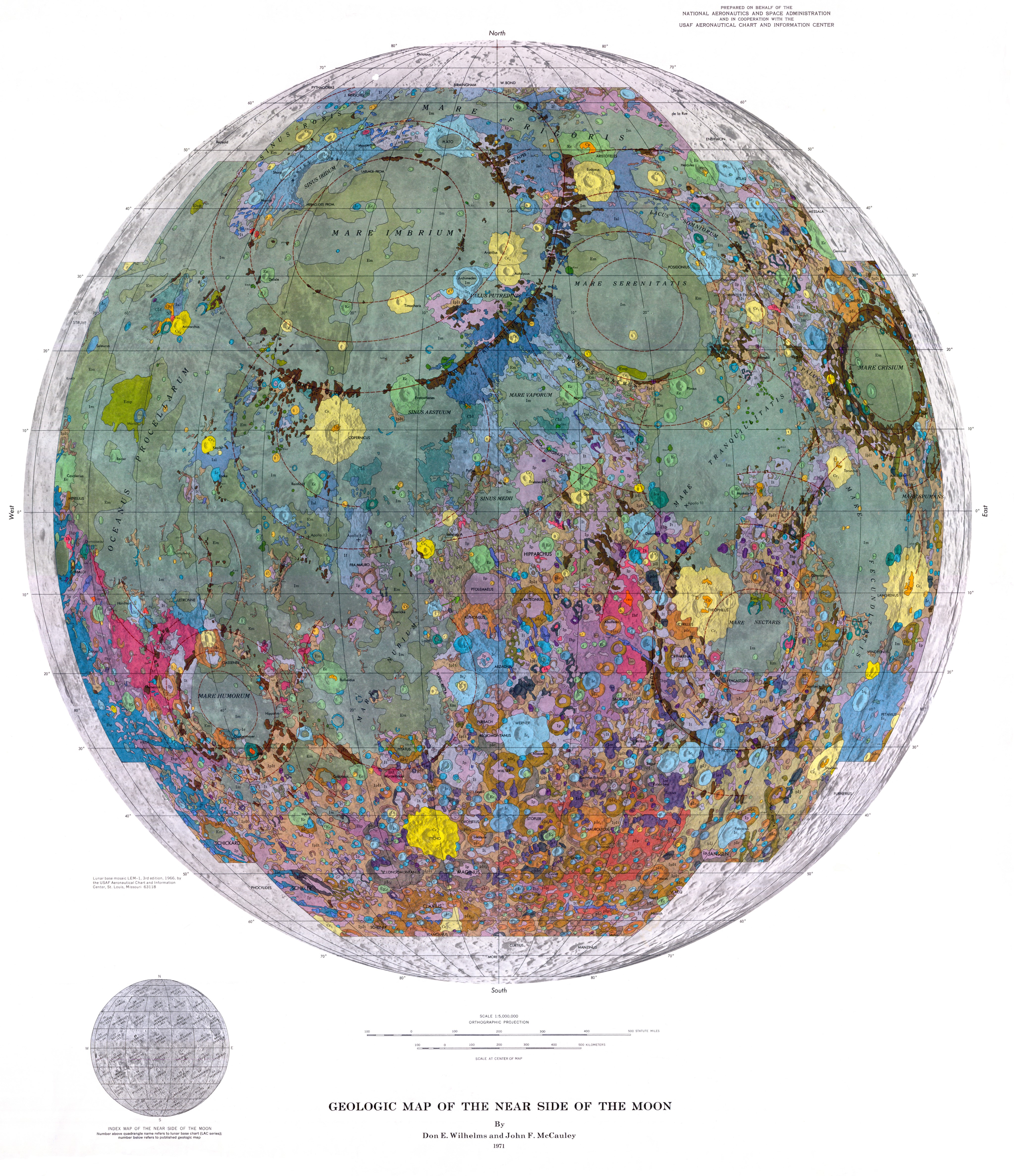
English: By Don E. Wilhelms and John F. McCauley
Prepared on behalf of the National Aeronautics and Space Administration (NASA) and in cooperation with the USAF Aeronautical Chart and Information Center (Now part of the U.S. Department of Defense's National Geospatial-Intelligence Agency) The chief purpose of the 1 :5,000,000-scale map is to summarize the current state of lunar geologic knowledge as developed from the U.S. Geological Survey's systematic lunar mapping program, which began in 1960. Like terrestrial synoptic maps it provides a stratigraphic framework to be used for developing new theory and for determining the regional significance of surface exploration results. The geologic summary which accompanies the map gives the major genetic and historical conclusions which stem from the work. The map explanation provides the descriptive details that led to these conclusions. This pamphlet discusses the rationale methods, and nomenclature of lunar stratigraphy: specifically for those interested in why and how the map was produced. The work is based both on results of the telescopic mapping program and on data from the unmanned lunar exploration program, particularly the regional coverage of Lunar Orbiter IV1 The early telescopic studies established the geologic heterogeneity of the Moon and produced a workable nearside stratigraphy (Shoemaker and Hackman, 1962; McCauley, 1967b; Wilhelms, 1970b). Prior to the Lunar Orbiters, telescopic resolution limitations dictated emphasis on the grosser aspects of lunar geology: the structures and ejecta blankets associated with the multiringed basins, the major craters, and the stratigraphic relations between the generally younger maria and older terrae. The main products of the telescopic work were 36 1:1 ,000,000-scale geologic quadrangle maps and a 1 :5,000,000-scale preliminary map of the region 32°N. to 32°S. and 70°E. to 70°W. (Wilhelms, Trask, and Keith, 1965). Before the systematic program began, Hackman and Mason (1961) produced a set of three nearside maps at a scale of 1:3,800,000 from telescopic data; these maps emphasized the geology, physiography and ray-crater distribution. |
| Datum | |
| Bron | https://www.lpi.usra.edu/resources/mapcatalog/usgs/ |
| Auteur | Don E. Wilhems and John F. McCauley (USGS) |
Licentie
Dit werk bevindt zich in het publieke domein in de Verenigde Staten omdat het is vervaardigd door een ambtenaar van de Amerikaanse federale overheid tijdens de uitoefening van zijn functie, en het daarmee volgens Titel 17, Hoofdstuk 1, Sectie 105 van de United States Code [Engelstalige link] een werk van de Amerikaanse federale overheid [Engelstalige link] is.
Nota bene: Het bovenstaande is alleen van toepassing op werken van de federale overheid of een van haar onderdelen, en niet op werken van een afzonderlijk(e) Staat, Territorium, Commonwealth, County, Gemeente, of enig andere bestuurlijke eenheid. Dit sjabloon is ook niet van toepassing op ontwerpen voor postzegels, door de United States Postal Service openbaar gemaakt sinds 1978 [Engelstalige link]. Zie Art. 206.02(b) van "Compendium II: Copyright Office Practices" (Engelstalig).
|
 | |
| Van dit bestand is vastgesteld dat er geen bekende auteursrechtaanspraken op rusten, alle aanverwante en naburige rechten daarbij inbegrepen. | ||
Bestandsgeschiedenis
Klik op een datum/tijd om het bestand te zien zoals het destijds was.
| Datum/tijd | Miniatuur | Afmetingen | Gebruiker | Opmerking | |
|---|---|---|---|---|---|
| huidige versie | 15 apr 2021 23:36 | | 4.094 × 4.746 (4,37 MB) | Bridgman | Uploaded a work by Don E. Wilhems and John F. McCauley (USGS) from https://www.lpi.usra.edu/resources/mapcatalog/usgs/ with UploadWizard |
Bestandsgebruik
Dit bestand wordt op de volgende pagina gebruikt:
Globaal bestandsgebruik
De volgende andere wiki's gebruiken dit bestand:
- Gebruikt op en.wikiquote.org