Bestand:Flags of convenience.png
Grootte van deze voorvertoning: 800 × 406 pixels. Andere resoluties: 320 × 162 pixels | 640 × 325 pixels | 1.024 × 519 pixels | 1.280 × 649 pixels | 4.000 × 2.029 pixels.
Oorspronkelijk bestand (4.000 × 2.029 pixels, bestandsgrootte: 723 kB, MIME-type: image/png)
| Dit is een bestand van Wikimedia Commons. Onderstaande beschrijving komt van de beschrijving van het bestand daar. |
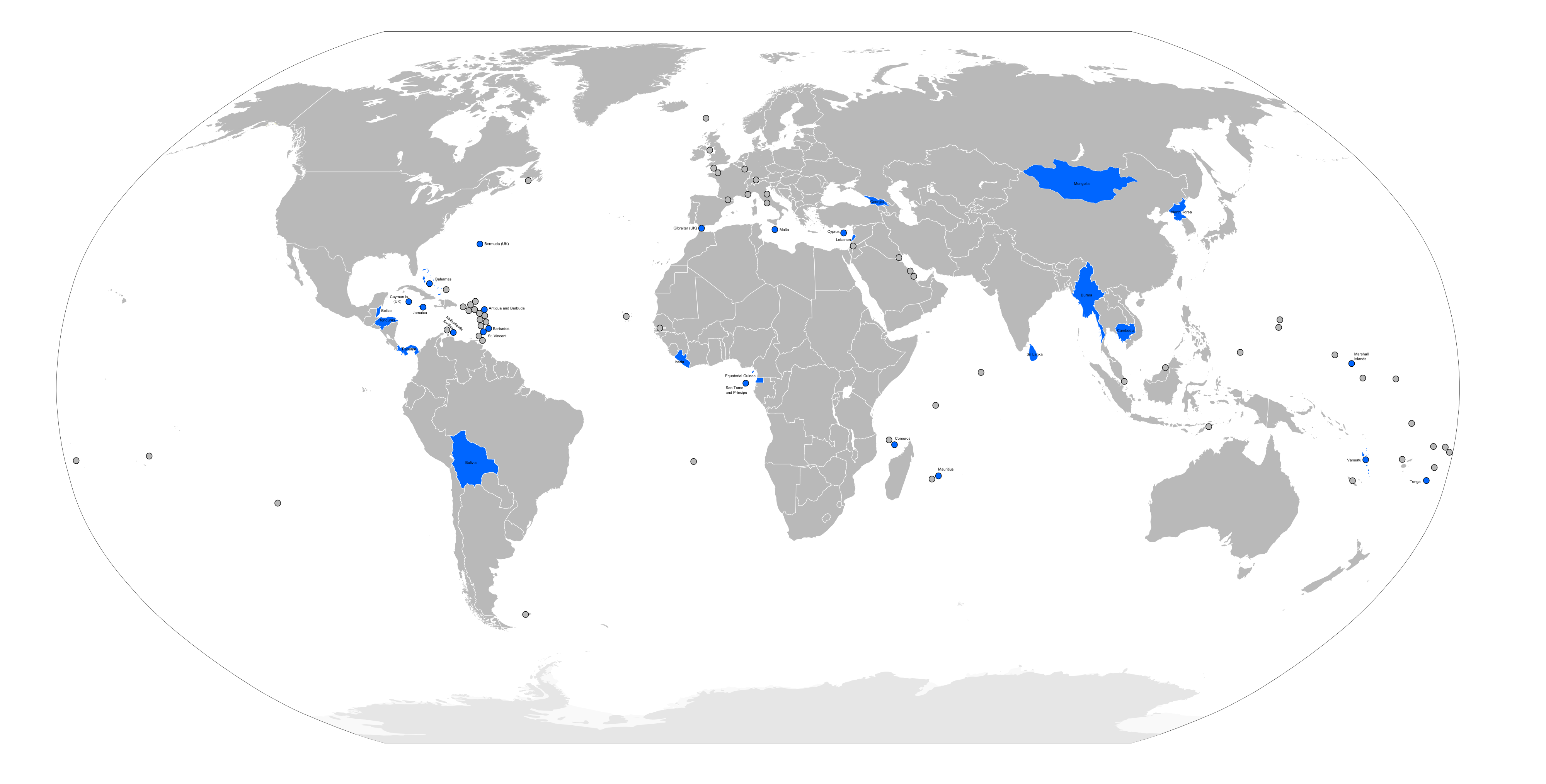
| Beschrijving | Flags of convenience countries and territories (marked in blue), as listed by the w:International Transport Workers' Federation on [1] |
| Datum | |
| Bron | self-made from Image:BlankMap-World6.svg |
| Auteur | self |
Ik, de auteursrechthebbende van dit werk, maak het hierbij onder de volgende licenties beschikbaar:

|
Toestemming wordt verleend voor het kopiëren, verspreiden en/of wijzigen van dit document onder de voorwaarden van de GNU-licentie voor vrije documentatie, versie 1.2 of enige latere versie als gepubliceerd door de Free Software Foundation; zonder Invariant Sections, zonder Front-Cover Texts, en zonder Back-Cover Texts. Een kopie van de licentie is opgenomen in de sectie GNU-licentie voor vrije documentatie. |
| Dit bestand is gelicenseerd onder de Creative Commons-licentie Naamsvermelding-Gelijk delen 3.0 Unported | ||
| ||
| Deze licentietag is toegevoegd aan dit bestand in verband met de GFDL licentie-update. |
U mag zelf één van de licenties kiezen.
Bestandsgeschiedenis
Klik op een datum/tijd om het bestand te zien zoals het destijds was.
| Datum/tijd | Miniatuur | Afmetingen | Gebruiker | Opmerking | |
|---|---|---|---|---|---|
| huidige versie | 26 okt 2008 11:51 | | 4.000 × 2.029 (723 kB) | RaviC | fixed. cayman islands are part of U.K (British overseas territory) |
| 2 apr 2008 04:29 |  | 4.000 × 2.029 (623 kB) | Hoshie | fixed map. Aruba is not part of the Neth. Anilles; the Marshall Islands are a independent country like Germany, France, Britain, etc. | |
| 26 jun 2007 00:15 |  | 4.000 × 2.029 (738 kB) | Roke~commonswiki | ||
| 24 mei 2007 11:32 |  | 4.000 × 2.029 (921 kB) | Roke~commonswiki | {{Information |Description= Flags of convenience countries and territories, as listed by the w:International Transport Workers' Federation on [http://www.itfglobal.org/flags-convenience/flags-convenien-183.cfm] |Source=self-made from [[:Image:BlankMa |
Bestandsgebruik
Dit bestand wordt op de volgende pagina gebruikt:
Globaal bestandsgebruik
De volgende andere wiki's gebruiken dit bestand:
- Gebruikt op da.wikipedia.org
- Gebruikt op en.wikipedia.org
- Gebruikt op et.wikipedia.org
- Gebruikt op fa.wikipedia.org
- Gebruikt op ga.wikipedia.org
- Gebruikt op hr.wikipedia.org
- Gebruikt op id.wikipedia.org
- Gebruikt op it.wikipedia.org
- Gebruikt op pl.wikipedia.org