Bestand:F. Müllhaupt's Militarische & Verkehrs-Karte der Deutsch-Französischen Grenze...jpg

Oorspronkelijk bestand (8.150 × 6.978 pixels, bestandsgrootte: 75,1 MB, MIME-type: image/jpeg)
| Dit is een bestand van Wikimedia Commons. Onderstaande beschrijving komt van de beschrijving van het bestand daar. |
| Beschrijving |
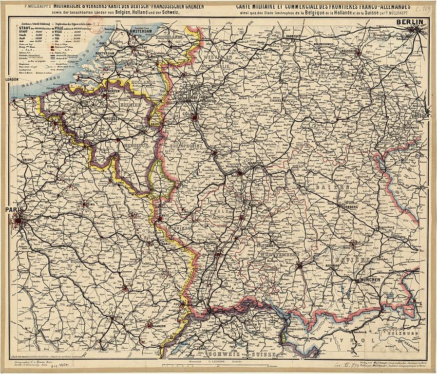
Titre : Deutsch: F. Müllhaupt's Militärische & Verkehr's-Karte der Deutsch-Französischen Grenzen (...) Français : Carte militaire et commerciale des frontières franco-allemandes ainsi que des Etats limitrophes de la Belgique, de la Hollande et de la Suisse / par F. Müllhaupt English: Map military and commercial Franco-German border and the neighboring states of Belgium, Holland and Switzerland
Auteur : Müllhaupt, Fritz (1846-1917) Éditeur : Müllhaupt Date d'édition : 1885 Sujet : Frontières Sujet : Allemagne, Empire d' -- Sud-Ouest -- Frontières Sujet : Belgique -- Est -- Frontières Sujet : Suisse -- Frontières Sujet : France -- Nord-Est -- Frontières Sujet : Pays-Bas -- Frontières Type : document cartographique,carte,image fixe Langue : Multilingue Format : 1 flle en coul. ; 680 x 580 Format : image/jpeg Droits : domaine public Identifiant : ark:/12148/btv1b53023072n Source : Bibliothèque nationale de France, département Cartes et plans, GE C-859 Relation : http://catalogue.bnf.fr/ark:/12148/cb405950294 Couverture : Belgique Couverture : Suisse Couverture : France Couverture : Pays-Bas Description : Échelle(s) : 1:1 250 000 Provenance : bnf.fr |
||||
| Datum | |||||
| Bron | F. Müllhaupt's Militarische & Verkehrs-Karte der Deutsch-Französischen Grenze | ||||
| Auteur | Müllhaupt, Fritz (1846-1917) | ||||
| Toestemming (Hergebruik van dit bestand) |
|
| Open this image as an overlay in Google Earth (Google Maps, Bing) | (Help|Source) |
|
Deze afbeelding is geselecteerd als afbeelding van de dag op 30 mei 2013. De afbeelding heeft de volgende beschrijving: Nederlands: Militaire kaart van F. Müllhaupt met de Frans-Duitse grens met de nabijgelegen staten België, Nederland en Zwitserland. Andere talen:
Deutsch: F. Müllhaupt's Militarische & Verkehrs-Karte der Deutsch-Französischen Grenze.... English: Map military and commercial Franco-German border and the neighboring states of Belgium, Holland and Switzerland Français : Carte militaire et commerciale des frontières franco-allemandes ainsi que des Etats limitrophes de la Belgique, de la Hollande et de la Suisse / par F. Müllhaupt Italiano: Mappa militare e commerciale del confine franco-tedesco e dei vicini stati di Belgio, Paesi Bassi e Svizzera, risalente al 1885. Magyar: Müllhaupt katonai-közlekedési térképe a német-francia határvidékről és környezetéről Nederlands: Militaire kaart van F. Müllhaupt met de Frans-Duitse grens met de nabijgelegen staten België, Nederland en Zwitserland. Slovenščina: Vojaški in trgovski zemljevid francosko-nemške meje ter sosednjih držav Belgije, Nizozemske in Švice / avtor: F. Müllhaupt Русский: Карта франко-германской границы и близлежащих государств. 1885 год. 中文: 法德边境以及邻国比利时,荷兰和瑞士军事和商业地图。 |
| Aantekeningen | Deze afbeelding is aangetekend: Bekijk de aantekeningen op Commons |
Bestandsgeschiedenis
Klik op een datum/tijd om het bestand te zien zoals het destijds was.
| Datum/tijd | Miniatuur | Afmetingen | Gebruiker | Opmerking | |
|---|---|---|---|---|---|
| huidige versie | 4 apr 2013 15:02 | | 8.150 × 6.978 (75,1 MB) | ComputerHotline | {{LargeImage}} {{Information |Description= Titre : F. Müllhaupt's Militarische & Verkehrs-Karte der Deutsch-Französischen Grenze.... Carte militaire et commerciale des frontières franco-allemandes ainsi que des Etats limitrophes de la Belgique, de l... |
Bestandsgebruik
Dit bestand wordt op de volgende pagina gebruikt:
Globaal bestandsgebruik
De volgende andere wiki's gebruiken dit bestand:
- Gebruikt op be-tarask.wikipedia.org
- Gebruikt op bn.wikipedia.org
- Gebruikt op crh.wikipedia.org
- Gebruikt op cv.wikipedia.org
- Gebruikt op hu.wikipedia.org
- Gebruikt op ka.wikipedia.org
- Gebruikt op ko.wikipedia.org
- Gebruikt op krc.wikipedia.org
- Gebruikt op lbe.wikipedia.org
- Gebruikt op os.wikipedia.org
- Gebruikt op pt.wikipedia.org
- Gebruikt op ru.wikipedia.org
- Gebruikt op ru.wikinews.org
- Gebruikt op sah.wikipedia.org
- Gebruikt op sq.wikipedia.org
- Gebruikt op uk.wikipedia.org
- Gebruikt op vi.wikipedia.org
- Gebruikt op xal.wikipedia.org
- Gebruikt op zh.wikipedia.org