Oorspronkelijk bestand(1.075 × 1.168 pixels, bestandsgrootte: 114 kB, MIME-type: image/png)


Beschrijving

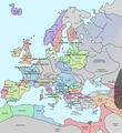
Beschrijving A map of Europe in 1345, showing the location of events that took place in that year. The Black Plague's exact location in unknown, and the shaded area to the right represents rough scholarly estimates. It hit the Crimea in the following year.
Datum
Bron self-made from Image:Europein1328.png with GIMP
Auteur Teaandcrumpets
Deze kaartafbeelding zou opnieuw moeten worden aangemaakt als een SVG-bestand door vectorafbeeldingen te gebruiken. Dit heeft een aantal voordelen; zie Commons:Media for cleanup voor meer informatie. Als er een SVG-formaat van deze afbeelding bestaat, dan deze graag uploaden. Nadat u dit heeft gedaan, gelieve dit sjabloon te vervangen door het sjabloon {{vector version available|nieuwe bestandsnaam.svg}} op deze afbeeldingspagina.
Kaarten van de geschiedenis van Europa
BCE
aC

Weichselian ice age (c. 113,000–9700) · Neolithic expansion (c. 7000–4500) · Middle Neolithic (c. 4500–4000) · Late Neolithic (c. 4000–3000) · Copper Age – Corded Ware culture (c. 2900–2350) · Copper Age – Bellbeaker culture (c. 2800–1800) · Early Bronze Age – Unetice culture (c. 2300–1600) · Late Bronze Age – Urnfield culture (c. 1300—750) · Migrations (c. 1000–100) · Hallstatt & La Tène cultures (c. 800–100) · Roman Republic (510–40) · 220 · 218 · 200 · 201–100 · 58 · 49 · 39 · 30 BCE–6 CE


CE
dC

14 · 14–37 · 60 · 60 · 69 · 80 · Migrations 100–500 · 117 · 117 · 125 · Migrations 150–774 · Economy 180 · 271 · 293–305 · 337 · 395 · c. 395 · 400 · 400 · 450 · 457–61 · 476 · 480 · Franks 481–814 · Early Slavs 500–700 · 500 · 526 · 526–600 · Christianisation to 600 · c. 550 · 650 · Pontic Steppe 650 · 665 · 800 · Vikings 800–1050 · 814 · 843–70 · 850 · 900 · 912 · 998 · 1000 · 1000 · 1054 · 1092 · First Crusade 1095–99 · 1097 · 1135 · 1142 · 1147–49 · 1190 · 1190 · 1250 · c. 1250 · 1301-1400 · 1301-1400 · 1328 · 1345 · Black Plague 1347–51 · 1360 · 1400 · Trade routes c. 1400 · 1430 · 1470 · 1490 · 1492 · 1500 · 1519 · 1550 · 1560 · Religion 1560 · Religion 1600 · Religion 1618 · 1618–48 · 1648 · 1683 · 1700 · 1701 · 1708 · 1714 · 1721 · 1725–30 · 1739–1740 · 1740 · 1748–66 · 1783–1792 · 1787 · 1787 · 1789 · 1799 · 1812 · 1812 · 1812 · 1812 · 1813 · 1815 · 1815 · 1815 · 1818 · Ottoman Empire 1830–1923 · 1848–49 · 1861 · 1867 · 1871 · 1878 · 1890 · 1905 · 1911 · 1914 · 1914 · 1919 · 1919–29 · 1923 · 1929 · 1930 · 1940 · 1941–42 · 1942–45 · Cold War 1947–91 · 1950 · 1993–2006 · 2006 to date

(this template: · view · discuss )

Licentie

Public domain Ik, de auteursrechthebbende van dit werk, geef dit werk vrij in het publieke domein. Dit is wereldwijd van toepassing.
In sommige landen is dit wettelijk niet mogelijk; in die gevallen geldt:
Ik sta iedereen toe dit werk voor eender welk doel te gebruiken, zonder enige voorwaarden, tenzij zulke voorwaarden door de wet worden voorgeschreven.

Bijschriften

Beschrijf in één regel wat dit bestand voorstelt

Items getoond in dit bestand

beeldt af

Bestandsgeschiedenis

Klik op een datum/tijd om het bestand te zien zoals het destijds was.

Datum/tijdMiniatuurAfmetingenGebruikerOpmerking
huidige versie10 mei 2020 21:31Miniatuurafbeelding voor de versie van 10 mei 2020 21:311.075 × 1.168 (114 kB)Santasa99Corrections per Euroatlas - Historical Maps, http://www.euratlas.net/history/europe/1300/index.html Euratlas Periodis Web - Map of Europe in Year 1300
24 dec 2017 14:58Miniatuurafbeelding voor de versie van 24 dec 2017 14:581.075 × 1.168 (289 kB)Trey KincaidChanged Sicily who had his own kingdom
1 jul 2012 21:30Miniatuurafbeelding voor de versie van 1 jul 2012 21:301.075 × 1.168 (282 kB)Ludde23Changed Estonia from the red color of Sweden to the yellow color of Denmark, since Estonia was not Swedish at this time, but belonged to Denmark until 1346.
24 apr 2009 23:34Miniatuurafbeelding voor de versie van 24 apr 2009 23:341.075 × 1.168 (112 kB)Alex:DBorders corrected
15 nov 2007 20:02Miniatuurafbeelding voor de versie van 15 nov 2007 20:021.075 × 1.168 (110 kB)Teaandcrumpets(changed notre dame marker)
14 nov 2007 01:03Miniatuurafbeelding voor de versie van 14 nov 2007 01:031.075 × 1.168 (113 kB)Teaandcrumpets{{Information |Description= A map of Europe in 1345, showing the location of events that took place in that year. |Source=self-made from Image:Europein1328.png with GIMP |Date= 13 Nov 2007 |Author= Teaandcrumpets |Permission=

Geen enkele pagina gebruikt dit bestand.

Globaal bestandsgebruik

De volgende andere wiki's gebruiken dit bestand:

Metadata