Bestand:ElectoralCollege1996-Large.png
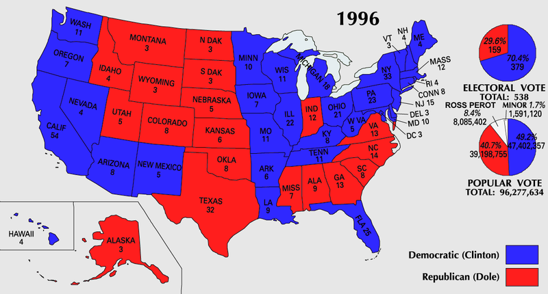
Oorspronkelijk bestand(1.182 × 635 pixels, bestandsgrootte: 171 kB, MIME-type: image/png)


U.S. presidential election maps
from the National Atlas of the United States
See also: SVG maps
1789 · 1792 · 1796 · 1800 · 1804 · 1808 · 1812 · 1816 · 1820 · 1824 · 1828 · 1832 · 1836 · 1840 · 1844 · 1848 · 1852 · 1856 · 1860 · 1864 · 1868 · 1872 · 1876 · 1880 · 1884 · 1888 · 1892 · 1896 · 1900 · 1904 · 1908 · 1912 · 1916 · 1920 · 1924 · 1928 · 1932 · 1936 · 1940 · 1944 · 1948 · 1952 · 1956 · 1960 · 1964 · 1968 · 1972 · 1976 · 1980 · 1984 · 1988 · 1992 · 1996 · 2000 · 2004

(this template: · view · discuss)


Beschrijving

Beschrijving
English: 1996 Electoral College Map
Bron https://nationalmap.gov/small_scale/printable/elections.html
Auteur United States Geological Survey
Andere versies
Bestand:ElectoralCollege1996WithPieCharts.svg is een vectorversie van dit bestand. Indien niet van slechtere kwaliteit dient deze gebruikt te worden in plaats van deze rasterafbeelding.

File:ElectoralCollege1996-Large.png → File:ElectoralCollege1996WithPieCharts.svg

Zie Help:SVG voor meer informatie.

In andere talen
Alemannisch  Bahasa Indonesia  Bahasa Melayu  British English  català  čeština  dansk  Deutsch  eesti  English  español  Esperanto  euskara  français  Frysk  galego  hrvatski  Ido  italiano  lietuvių  magyar  Nederlands  norsk bokmål  norsk nynorsk  occitan  Plattdüütsch  polski  português  português do Brasil  română  Scots  sicilianu  slovenčina  slovenščina  suomi  svenska  Tiếng Việt  Türkçe  vèneto  Ελληνικά  беларуская (тарашкевіца)  български  македонски  нохчийн  русский  српски / srpski  татарча/tatarça  українська  ქართული  հայերեն  বাংলা  தமிழ்  മലയാളം  ไทย  한국어  日本語  简体中文  繁體中文  עברית  العربية  فارسی  +/−
SVG-bestand

Licentie

Public domain
This map was obtained from an edition of the National Atlas of the United States. Like almost all works of the U.S. federal government, works from the National Atlas are in the public domain in the United States.
Online access: NationalAtlas.gov | 1970 print edition: Library of Congress, Perry-Castañeda Library

čeština | Deutsch | English | français | Bahasa Indonesia | italiano | македонски | മലയാളം | sicilianu | 中文 | 中文(简体)‎ | 中文(繁體)‎ | +/−

Bestandsgeschiedenis

Klik op een datum/tijd om het bestand te zien zoals het destijds was.

Datum/tijdMiniatuurAfmetingenGebruikerOpmerking
huidige versie25 jul 2007 12:21Miniatuurafbeelding voor de versie van 25 jul 2007 12:211.182 × 635 (171 kB)Cardsplayer4life~commonswikiReverted to earlier revision
25 jul 2007 11:25Miniatuurafbeelding voor de versie van 25 jul 2007 11:251.182 × 635 (110 kB)Joseph Solis in Australia~commonswiki{{PD-USGov-Atlas}} Category:1996 {{US presidential election maps}}
9 jul 2007 03:48Miniatuurafbeelding voor de versie van 9 jul 2007 03:481.182 × 635 (171 kB)Cardsplayer4life~commonswiki{{PD-USGov-Atlas}} Category:1996 {{US presidential election maps}}
6 jul 2007 11:31Miniatuurafbeelding voor de versie van 6 jul 2007 11:311.182 × 635 (110 kB)Joseph Solis in Australia~commonswiki{{PD-USGov-Atlas}} Category:1996 {{US presidential election maps}}
2 jul 2007 04:30Miniatuurafbeelding voor de versie van 2 jul 2007 04:301.182 × 635 (171 kB)Cardsplayer4life~commonswiki{{PD-USGov-Atlas}} Category:1996 {{US presidential election maps}}
29 jun 2007 12:06Miniatuurafbeelding voor de versie van 29 jun 2007 12:061.182 × 635 (110 kB)Joseph Solis in Australia~commonswiki{{PD-USGov-Atlas}} Category:1996 {{US presidential election maps}}
21 jun 2007 23:02Miniatuurafbeelding voor de versie van 21 jun 2007 23:021.182 × 635 (171 kB)Cardsplayer4life~commonswiki{{PD-USGov-Atlas}} Category:1996 {{US presidential election maps}}
22 jan 2006 17:57Miniatuurafbeelding voor de versie van 22 jan 2006 17:571.182 × 635 (110 kB)Red devil 666{{PD-USGov-Atlas}}

Geen enkele pagina gebruikt dit bestand.

Globaal bestandsgebruik

De volgende andere wiki's gebruiken dit bestand: