Bestand:Divided Yemen.svg

Afmetingen van deze voorvertoning van het type PNG van dit SVG-bestand: 800 × 483 pixels Andere resoluties: 320 × 193 pixels | 640 × 386 pixels | 1.024 × 618 pixels | 1.280 × 772 pixels | 2.560 × 1.544 pixels | 1.210 × 730 pixels.
Oorspronkelijk bestand (SVG-bestand, nominaal 1.210 × 730 pixels, bestandsgrootte: 71 kB)
| Dit is een bestand van Wikimedia Commons. Onderstaande beschrijving komt van de beschrijving van het bestand daar. |

|
Dit SVG-bestand maakt gebruik van geïntegreerde tekst die gemakkelijk kan worden vertaald naar uw taal met een SVG editor, een tekstverwerker of het hulpmiddel SVG Translate. Uitleg |
Beschrijving
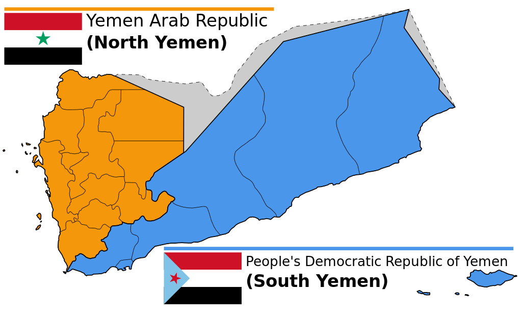
| Beschrijving |
English: Map of North and South Yemen prior to unification.
Español: Yemen previo a la unificación, en 1990.
Français : Le Yémen avant l'unification.
Português: Iêmen do Norte (em laranja) e Iêmen do Sul (em azul) antes de 1990. |
| Datum | (UTC) |
| Bron | |
| Auteur |
|
| Andere versies |
|


.svg)


Licentie
Dit bestand is gelicenseerd onder de Creative Commons-licentie Naamsvermelding-Gelijk delen 3.0 Unported
- De gebruiker mag:
- Delen – het werk kopiëren, verspreiden en doorgeven
- Remixen – afgeleide werken maken
- Onder de volgende voorwaarden:
- naamsvermelding – U moet op een gepaste manier aan naamsvermelding doen, een link naar de licentie geven, en aangeven of er wijzigingen in het werk zijn aangebracht. U mag dit op elke redelijke manier doen, maar niet zodanig dat de indruk wordt gewekt dat de licentiegever instemt met uw werk of uw gebruik van zijn werk.
- Gelijk delen – Als u het werk heeft geremixt, veranderd, of erop heeft voortgebouwd, moet u het gewijzigde materiaal verspreiden onder dezelfde licentie als het oorspronkelijke werk, of een daarmee compatibele licentie.
Oorspronkelijk uploadlogboek
This image is a derivative work of the following images:
- File:Map_of_North_and_South_Yemen.png licensed with Cc-by-sa-3.0, GFDL
- 2011-03-21T17:54:35Z Orange Tuesday 1600x1024 (63249 Bytes) 1600 px wide
- 2011-03-21T17:51:50Z Orange Tuesday 1598x1024 (63069 Bytes) {{Information |Description ={{en|1=Map of North and South Yemen prior to unification.}} |Source ={{own}} |Author =[[User:Orange Tuesday|Orange Tuesday]] |Date = |Permission = |other_versions =
- File:Flag_of_North_Yemen.svg licensed with PD-shape
- 2011-08-22T05:56:53Z Alkari 900x600 (731 Bytes) code cleanup; star precision; file size
- 2010-06-27T03:28:25Z Fry1989 900x600 (2295 Bytes) red
- 2006-01-17T05:29:39Z B1mbo 900x600 (665 Bytes) Few corrections
- 2006-01-17T05:15:33Z B1mbo 900x600 (1963 Bytes) == Sumario == {{en|Flag of the [[:en:Yemen Arab Republic|Yemen Arab Republic (North Yemen)]] (1962-1990)}} {{es|Bandera de la [[:es:Yemen del Norte|República Árabe de Yemen (Yemen del Norte)]] (1962-1990)}} [[Category:Flag
- File:Flag_of_South_Yemen.svg licensed with PD-self
- 2011-08-22T06:02:04Z Alkari 1800x1200 (804 Bytes) code cleanup; star precision
- 2010-06-27T03:26:35Z Fry1989 1800x1200 (2702 Bytes) shades
- 2006-01-08T18:55:08Z Dbenbenn 1800x1200 (946 Bytes) by me, PD. Based on https://www.fotw.info/flags/ye-south.html
- 2006-01-04T23:52:54Z Chanheigeorge 195x130 (3741 Bytes) Converted from Image:South_Yemen_Flag.PNG
- File:Governorates_of_Yemen_named.svg licensed with Cc-by-sa-2.5,2.0,1.0, Cc-by-sa-3.0-migrated, GFDL
- 2007-05-23T17:35:54Z Jarke 1208x719 (77247 Bytes) == Sumario == {{Information |Description={{en|Governorates of Yemen, after 2004}} {{es|Governaciones de Yemen, después del 2004}} |Source=SVG version of [[:Image:Yemen governorates numbered english.png]] and [[:Imagen:Yemen
Uploaded with derivativeFX
Bestandsgeschiedenis
Klik op een datum/tijd om het bestand te zien zoals het destijds was.
| Datum/tijd | Miniatuur | Afmetingen | Gebruiker | Opmerking | |
|---|---|---|---|---|---|
| huidige versie | 20 dec 2023 16:58 | | 1.210 × 730 (71 kB) | אורי9 | File uploaded using svgtranslate tool (https://svgtranslate.toolforge.org/). Added translation for he. |
| 8 nov 2020 21:47 |  | 1.210 × 730 (71 kB) | Panam2014 | Reverted to version as of 18:27, 8 July 2019 (UTC) | |
| 9 aug 2020 10:46 |  | 1.210 × 730 (44 kB) | AlMahra67 | text | |
| 3 aug 2020 20:05 |  | 1.210 × 730 (39 kB) | AlMahra67 | Changed dimensions | |
| 3 aug 2020 19:50 |  | 512 × 309 (39 kB) | AlMahra67 | If this map is supposed to show South and North Yemen division currently then it should be like this. The current divisions are based on the former divisions between the North and South Yemen. The previous version showed the new administrative boundaries that were created after unity. The new administrative boundary split areas that were part of the south. For example Dhale and Mukayras are shown as part of the North when they are in fact Southern. | |
| 12 aug 2019 01:07 |  | 1.210 × 730 (47 kB) | SharabSalam | Reverted to version as of 19:35, 20 October 2012 (UTC) none of these sources support this map. This map suppose to show South and North Yemen division currently.. Also Asir, Jazan and Najran should be part of North Yemen if it's a historical map. | |
| 8 jul 2019 20:27 |  | 1.210 × 730 (71 kB) | Flappiefh | This map is supposed to show these two former countries before their union (before 1990). It now shows the right governorates. Source 1 : https://legacy.lib.utexas.edu/maps/atlas_middle_east/yemen_divisions.jpg Source 2 : http://users.ox.ac.uk/~metheses/Ismail%20Thesis.pdf | |
| 23 sep 2018 13:57 |  | 1.210 × 730 (68 kB) | Nicolay Sidorov | ... | |
| 23 sep 2018 13:52 |  | 1.210 × 730 (65 kB) | Nicolay Sidorov | true border | |
| 11 jun 2016 10:59 |  | 1.210 × 730 (47 kB) | Flappiefh | Removed Dhale Governorate because it didn't exist at that time (created after 1990 unification). |
Bestandsgebruik
Dit bestand wordt op de volgende 2 pagina's gebruikt:
Globaal bestandsgebruik
De volgende andere wiki's gebruiken dit bestand:
- Gebruikt op af.wikipedia.org
- Gebruikt op bn.wikipedia.org
- Gebruikt op ca.wikipedia.org
- Gebruikt op cs.wikipedia.org
- Gebruikt op en.wikipedia.org
- Gebruikt op es.wikipedia.org
- Gebruikt op eu.wikipedia.org
- Gebruikt op fa.wikipedia.org
- Gebruikt op fi.wikipedia.org
- Gebruikt op fr.wikipedia.org
- Gebruikt op gl.wikipedia.org
- Gebruikt op he.wikipedia.org
- פורטל:גאוגרפיה/הידעת?/קטעי הידעת
- פורטל:המזרח התיכון/הידעת?/קטעי הידעת?
- ויקיפדיה:הידעת?/ממרץ 2016
- איחוד תימן
- ויקיפדיה:הידעת?/2017/ינואר
- תבנית:הידעת? 071
- תבנית:הידעת? 30 בינואר 2017
- ויקיפדיה:הידעת?/2021/אוקטובר
- תבנית:הידעת? 20 באוקטובר 2021
- פורטל:גאוגרפיה/הידעת?/34
- פורטל:המזרח התיכון/הידעת?/63
- התנועה הדרומית
- Gebruikt op hr.wikipedia.org
- Gebruikt op hu.wikipedia.org
- Gebruikt op hy.wikipedia.org
- Gebruikt op id.wikipedia.org
- Gebruikt op it.wikipedia.org
- Gebruikt op ja.wikipedia.org
- Gebruikt op ka.wikipedia.org
- Gebruikt op ms.wikipedia.org
- Gebruikt op nn.wikipedia.org
- Gebruikt op or.wikipedia.org
- Gebruikt op sr.wikipedia.org
- Gebruikt op te.wikipedia.org
- Gebruikt op tg.wikipedia.org
- Gebruikt op tr.wikipedia.org
- Gebruikt op uk.wikinews.org
Globaal gebruik van dit bestand bekijken.