Bestand:Diocese of Africa - AD 400.png
Grootte van deze voorvertoning: 800 × 554 pixels. Andere resoluties: 320 × 222 pixels | 640 × 443 pixels | 1.024 × 709 pixels | 1.280 × 886 pixels | 1.697 × 1.175 pixels.
Oorspronkelijk bestand (1.697 × 1.175 pixels, bestandsgrootte: 1,94 MB, MIME-type: image/png)
| Dit is een bestand van Wikimedia Commons. Onderstaande beschrijving komt van de beschrijving van het bestand daar. |
Beschrijving
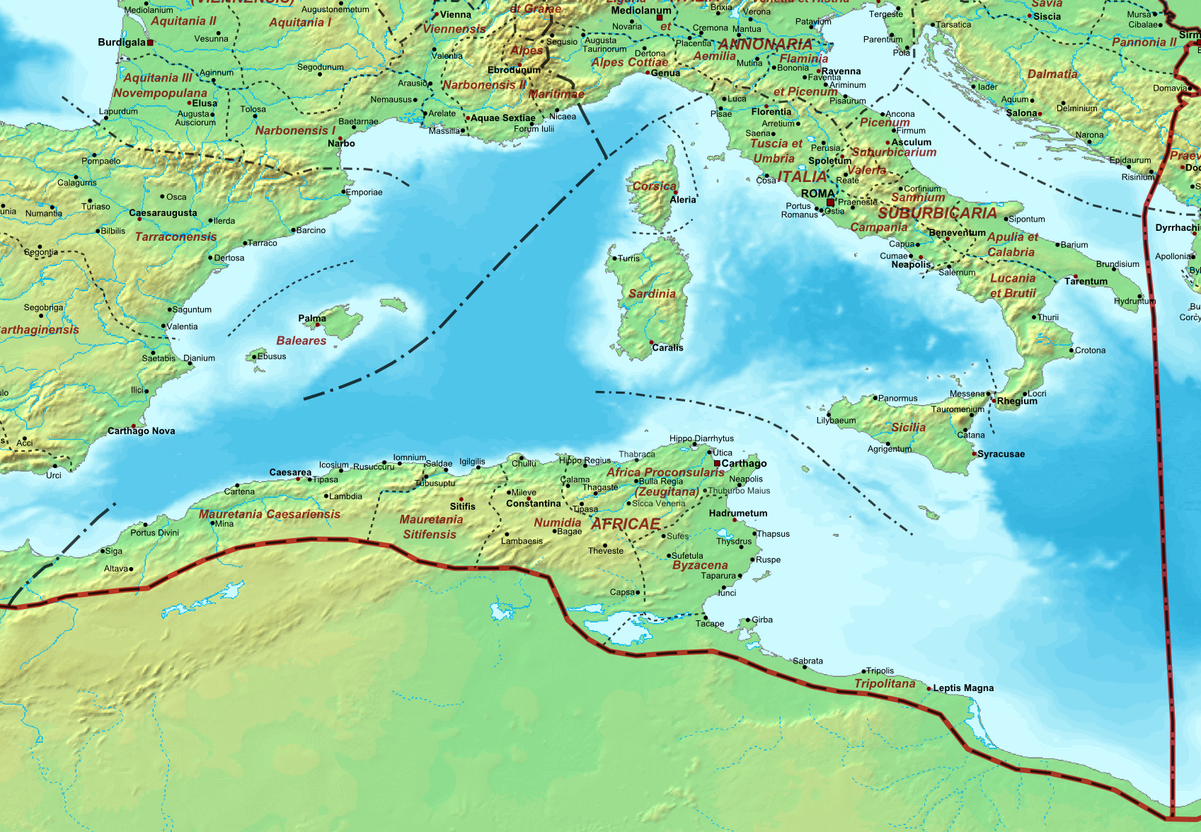
| Beschrijving | Map of the Roman Empire ca. 400 AD, showing the administrative division into dioceses and provinces, as well as the major cities. The demarcation between Eastern and Western Empires is noted in red. |
| Datum | (UTC) |
| Bron |
Dit bestand is afgeleid van: The Roman Empire ca 400 AD.png: |
| Auteur |
|
| Andere versies |
.png)
| Dit is een geretoucheerde foto, wat betekent dat de originele versie digitaal aangepast is. Aanpassingen: Diocese of Africa. Het origineel kan hier bekeken worden: The Roman Empire ca 400 AD.png. Aanpassingen gedaan door Jbribeiro1.
|
Licentie
Ik, de auteursrechthebbende van dit werk, maak het hierbij onder de volgende licentie beschikbaar:
| Ik, de auteursrechthebbende van dit werk, geef dit werk vrij in het publieke domein. Dit is wereldwijd van toepassing. In sommige landen is dit wettelijk niet mogelijk; in die gevallen geldt: Ik sta iedereen toe dit werk voor eender welk doel te gebruiken, zonder enige voorwaarden, tenzij zulke voorwaarden door de wet worden voorgeschreven. |
Oorspronkelijk uploadlogboek
This image is a derivative work of the following images:
- File:The_Roman_Empire_ca_400_AD.png licensed with PD-self
- 2011-07-21T13:03:22Z Cplakidas 4339x2689 (11429663 Bytes) fixed Persian border, differentiated between Eastern and Western empire, different borders for praet. prefectures
- 2009-03-21T02:37:17Z Cplakidas 4475x2600 (10476876 Bytes) minor corrections
- 2008-05-29T12:30:03Z Cplakidas 3800x2370 (8491181 Bytes)
- 2008-05-29T12:17:05Z Cplakidas 4560x2850 (11764337 Bytes) clearer version & addition of the Armenian satrapies
- 2007-12-30T02:02:48Z Cplakidas 3380x2120 (6247724 Bytes) added names of dioceses, legend box, various minor adjustments
- 2007-12-13T14:27:35Z Cplakidas 3550x2200 (6970232 Bytes) new improved version made with Inkscape, slight corrections in borders, added several cities in Africa & Spain
- 2007-11-12T19:27:37Z Cplakidas 3550x2200 (4979411 Bytes) minor corrections in southern Gaul
- 2007-11-05T12:58:04Z Cplakidas 3550x2200 (4977196 Bytes) New version, with some corrections & additions
- 2007-10-31T16:55:48Z Cplakidas 3436x2142 (4722554 Bytes) {{Information |Description=Map of the [[Roman Empire]] ca. 400 AD, showing the administrative division into dioceses and provinces, as well as the major cities. The demarcation between Eastern and Western Empires is noted in
Uploaded with derivativeFX
Bestandsgeschiedenis
Klik op een datum/tijd om het bestand te zien zoals het destijds was.
| Datum/tijd | Miniatuur | Afmetingen | Gebruiker | Opmerking | |
|---|---|---|---|---|---|
| huidige versie | 22 dec 2013 22:08 | | 1.697 × 1.175 (1,94 MB) | Jbribeiro1 | == {{int:filedesc}} == {{Information |Description=Map of the Roman Empire ca. 400 AD, showing the administrative division into dioceses and provinces, as well as the major cities. The demarcation between Eastern and Western Empires is noted in red.... |
Bestandsgebruik
Dit bestand wordt op de volgende 6 pagina's gebruikt:
Globaal bestandsgebruik
De volgende andere wiki's gebruiken dit bestand:
- Gebruikt op ar.wikipedia.org
- Gebruikt op de.wikipedia.org
- Gebruikt op en.wikipedia.org
- Gebruikt op es.wikipedia.org
- Gebruikt op et.wikipedia.org
- Gebruikt op fi.wikipedia.org
- Gebruikt op fr.wikipedia.org
- Gebruikt op it.wikipedia.org
- Gebruikt op la.wikipedia.org
- Gebruikt op pt.wikipedia.org
- Gebruikt op sl.wikipedia.org
- Gebruikt op tr.wikipedia.org
- Gebruikt op uk.wikipedia.org
- Gebruikt op zh.wikipedia.org