Bestand:Carte de Wallis-et-Futuna.png

Geen hogere resolutie beschikbaar.
Carte_de_Wallis-et-Futuna.png (326 × 350 pixels, bestandsgrootte: 3 kB, MIME-type: image/png)
| Dit is een bestand van Wikimedia Commons. Onderstaande beschrijving komt van de beschrijving van het bestand daar. |
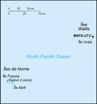
Beschrijving
Français : Carte de Wallis-et-Futuna
English: Map of Wallis and Futuna
Source : Wikipédia anglais venant du CIA World Factbook
Licentie
Deze afbeelding bevindt zich in het publiek domein omdat het materiaal bevat dat oorspronkelijk afkomstig is van het CIA World Factbook.
|
 |
Bestandsgeschiedenis
Klik op een datum/tijd om het bestand te zien zoals het destijds was.
| Datum/tijd | Miniatuur | Afmetingen | Gebruiker | Opmerking | |
|---|---|---|---|---|---|
| huidige versie | 29 sep 2005 00:53 | | 326 × 350 (3 kB) | Sanao | Carte de Wallis-et-Futuna<br /> Source : Wikipédia anglais venant du CIA World Factbook (http://en.wikipedia.org/wiki/Image:Wf-map.png) |
Bestandsgebruik
Dit bestand wordt op de volgende 2 pagina's gebruikt:
Globaal bestandsgebruik
De volgende andere wiki's gebruiken dit bestand:
- Gebruikt op af.wikipedia.org
- Gebruikt op ca.wikipedia.org
- Gebruikt op cs.wikipedia.org
- Gebruikt op es.wikipedia.org
- Gebruikt op fr.wikipedia.org
- Gebruikt op gl.wikipedia.org
- Gebruikt op it.wikipedia.org
- Gebruikt op nn.wikipedia.org
- Gebruikt op oc.wikipedia.org
- Gebruikt op pl.wikipedia.org
- Gebruikt op pl.wikivoyage.org
- Gebruikt op ro.wikipedia.org
- Gebruikt op sv.wikipedia.org