Bestand:Carte Lewis and Clark Expedition.png
Grootte van deze voorvertoning: 800 × 520 pixels. Andere resoluties: 320 × 208 pixels | 640 × 416 pixels | 1.024 × 665 pixels | 1.513 × 983 pixels.
Oorspronkelijk bestand (1.513 × 983 pixels, bestandsgrootte: 84 kB, MIME-type: image/png)
| Dit is een bestand van Wikimedia Commons. Onderstaande beschrijving komt van de beschrijving van het bestand daar. |

|
Deze kaartafbeelding zou opnieuw moeten worden aangemaakt als een SVG-bestand door vectorafbeeldingen te gebruiken. Dit heeft een aantal voordelen; zie Commons:Media for cleanup voor meer informatie. Als er een SVG-formaat van deze afbeelding bestaat, dan deze graag uploaden. Nadat u dit heeft gedaan, gelieve dit sjabloon te vervangen door het sjabloon {{vector version available|nieuwe bestandsnaam.svg}} op deze afbeeldingspagina.
|
Beschrijving
| Beschrijving |
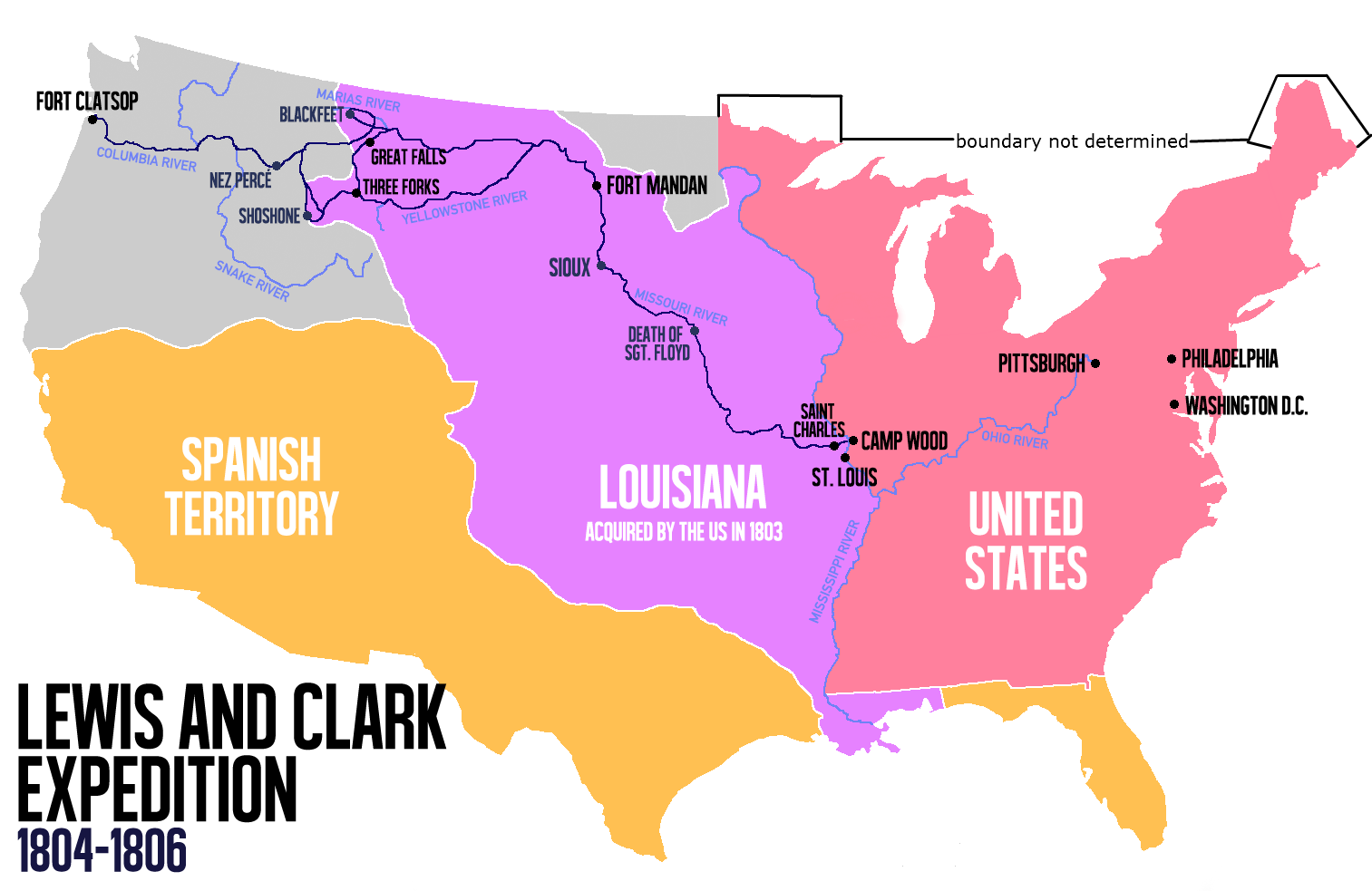
English: Route of the Lewis and Clark Expedition |
| Datum | |
| Bron |
Eigen werk, Dit bestand is afgeleid van: Carte Lewis-Clark Expedition-en.png |
| Auteur | Victor van Werkhooven |
| Andere versies |
 |
Licentie
| Ik, de auteursrechthebbende van dit werk, geef dit werk vrij in het publieke domein. Dit is wereldwijd van toepassing. In sommige landen is dit wettelijk niet mogelijk; in die gevallen geldt: Ik sta iedereen toe dit werk voor eender welk doel te gebruiken, zonder enige voorwaarden, tenzij zulke voorwaarden door de wet worden voorgeschreven. |
Bestandsgeschiedenis
Klik op een datum/tijd om het bestand te zien zoals het destijds was.
| Datum/tijd | Miniatuur | Afmetingen | Gebruiker | Opmerking | |
|---|---|---|---|---|---|
| huidige versie | 13 jun 2014 16:21 | | 1.513 × 983 (84 kB) | Nwbeeson | Reverted to version as of 14:18, 13 June 2014 |
| 13 jun 2014 16:20 |  | 1.513 × 983 (84 kB) | Nwbeeson | Corrected boundary of the United States. The original left out Maine, Michigan, Wisconsin, and part of Minnesota, none of which were states, but all of which were definitely part of the territory of the United States. | |
| 13 jun 2014 16:18 |  | 1.513 × 983 (84 kB) | Nwbeeson | Corrected boundary of the United States. The original left out Maine, Michigan, Wisconsin, and part of Minnesota, none of which were states, but all of which were definitely part of the territory of the United States. | |
| 22 mei 2014 17:17 |  | 1.513 × 983 (134 kB) | Luctor | User created page with UploadWizard |
Bestandsgebruik
Dit bestand wordt op de volgende pagina gebruikt:
Globaal bestandsgebruik
De volgende andere wiki's gebruiken dit bestand:
- Gebruikt op ast.wikipedia.org
- Gebruikt op bn.wikipedia.org
- Gebruikt op de.wikipedia.org
- Gebruikt op en.wikipedia.org
- Gebruikt op es.wikipedia.org
- Gebruikt op et.wikipedia.org
- Gebruikt op eu.wikipedia.org
- Gebruikt op fa.wikipedia.org
- Gebruikt op gl.wikipedia.org
- Gebruikt op hu.wikipedia.org
- Gebruikt op it.wikipedia.org
- Gebruikt op ko.wikipedia.org
- Gebruikt op ms.wikipedia.org
- Gebruikt op no.wikipedia.org
- Gebruikt op oc.wikipedia.org
- Gebruikt op pl.wikipedia.org
- Gebruikt op sr.wikipedia.org
- Gebruikt op tr.wikipedia.org
- Gebruikt op www.wikidata.org
- Gebruikt op zh.wikipedia.org