Bestand:Bosumtwi Worldwind SW.jpg

Grootte van deze voorvertoning: 800 × 584 pixels. Andere resoluties: 320 × 234 pixels | 640 × 467 pixels | 857 × 626 pixels.
Oorspronkelijk bestand (857 × 626 pixels, bestandsgrootte: 130 kB, MIME-type: image/jpeg)
| Dit is een bestand van Wikimedia Commons. Onderstaande beschrijving komt van de beschrijving van het bestand daar. |
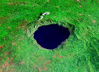
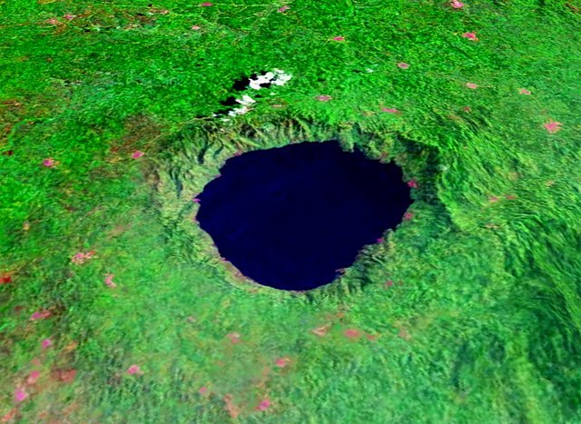
| Beschrijving | Lake Bosumtwi, Ghana, view from Southwest. Bosumtwiis a lake-filled impact crater, about 10.5 km in size an 1.3 million years old. Vertical exaggeration 3x. |
| Bron | Created with NASA WorldWind by User:Vesta using Landsat 7 (false color) satellite image. |
| Auteur | User:Vesta |
6°30′26″N 1°24′24″W / 6.50722°N 1.40667°W
| Deze afbeelding bevindt zich in het publiek domein omdat het een screenshot is van NASA’s software World Wind die gebruik maakt van een publiek domein-laag, zoals Blue Marble, MODIS, Landsat, SRTM, USGS of GLOBE.
|
 |
Bestandsgeschiedenis
Klik op een datum/tijd om het bestand te zien zoals het destijds was.
| Datum/tijd | Miniatuur | Afmetingen | Gebruiker | Opmerking | |
|---|---|---|---|---|---|
| huidige versie | 7 jan 2006 20:18 | | 857 × 626 (130 kB) | Vesta~commonswiki | *'''Description:''' Lake Bosumtwi, view from Southwest. Vertical exaggeration 3x. *'''Source:''' Created with NASA WorldWind by User:Vesta using Landsat 7 (false color) satellite image. {{PD-WorldWind}} Category:Impact craters |
Bestandsgebruik
Dit bestand wordt op de volgende pagina gebruikt:
Globaal bestandsgebruik
De volgende andere wiki's gebruiken dit bestand:
- Gebruikt op af.wikipedia.org
- Gebruikt op als.wikipedia.org
- Gebruikt op ar.wikipedia.org
- Gebruikt op ast.wikipedia.org
- Gebruikt op ceb.wikipedia.org
- Gebruikt op cs.wikipedia.org
- Gebruikt op cv.wikipedia.org
- Gebruikt op da.wikipedia.org
- Gebruikt op de.wikipedia.org
- Gebruikt op en.wikipedia.org
- Gebruikt op en.wikiversity.org
- Gebruikt op eo.wikipedia.org
- Gebruikt op es.wikipedia.org
- Gebruikt op et.wikipedia.org
- Gebruikt op eu.wikipedia.org
- Gebruikt op fi.wikipedia.org
- Gebruikt op fr.wikipedia.org
- Gebruikt op ha.wikipedia.org
- Gebruikt op hr.wikipedia.org
- Gebruikt op hy.wikipedia.org
- Gebruikt op id.wikipedia.org
- Gebruikt op it.wikipedia.org
- Gebruikt op ja.wikipedia.org
- Gebruikt op ka.wikipedia.org
- Gebruikt op ml.wikipedia.org
- Gebruikt op my.wikipedia.org
- Gebruikt op nn.wikipedia.org
- Gebruikt op pl.wikipedia.org
- Gebruikt op pt.wikipedia.org
- Gebruikt op ru.wikipedia.org
- Gebruikt op sh.wikipedia.org
- Gebruikt op sl.wikipedia.org
- Gebruikt op sr.wikipedia.org
Globaal gebruik van dit bestand bekijken.