Bestand:Auckland islands topo.png

Grootte van deze voorvertoning: 451 × 600 pixels. Andere resoluties: 180 × 240 pixels | 361 × 480 pixels | 577 × 768 pixels | 1.133 × 1.507 pixels.
Oorspronkelijk bestand (1.133 × 1.507 pixels, bestandsgrootte: 867 kB, MIME-type: image/png)
| Dit is een bestand van Wikimedia Commons. Onderstaande beschrijving komt van de beschrijving van het bestand daar. |
Beschrijving
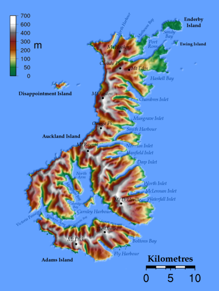
| Beschrijving | Topographic map of the Auckland Islands |
| Datum | |
| Bron | Eigen werk, SRTM data |
| Auteur | Jackaranga |
Licentie
The map has been created with the Generic Mapping Tools: https://www.generic-mapping-tools.org/ using one or more of these public-domain datasets for the relief:
|

|
Toestemming wordt verleend voor het kopiëren, verspreiden en/of wijzigen van dit document onder de voorwaarden van de GNU-licentie voor vrije documentatie, versie 1.2 of enige latere versie als gepubliceerd door de Free Software Foundation; zonder Invariant Sections, zonder Front-Cover Texts, en zonder Back-Cover Texts. Een kopie van de licentie is opgenomen in de sectie GNU-licentie voor vrije documentatie. |
| Dit bestand is gelicenseerd onder de Creative Commons-licentie Naamsvermelding-Gelijk delen 3.0 Unported | ||
| ||
| Deze licentietag is toegevoegd aan dit bestand in verband met de GFDL licentie-update. |
Info
- Made from SRTM 3 Arc Second, enhanced data from http://srtm.csi.cgiar.org/
- Used square number: 70_23, 55S -> 50S, 165S -> 175S FTP[dead link]
- Background: grdimage Z_70_23.grd -IZ_70_23_i.grd -Cauckland.cpt -P -R165.7/166.5/-51.1/50.3 -JB166.1/-50.7/-51/-50/24c -V >topo.ps
- Cpt file:
# cpt file created by: Thomas Dewez for elevations
#COLOR_MODEL = RGB
#
0     0       97      71      50      16      122     47
50   16      122     47      100    232     215     125
100  232     215     125     200    161     67      0
200  161     67      0       300    130     30      30
300  130     30      30      400    110     110     110
400  110     110     110     600    255     255     255
600  255     255     255     700    255     255     255
N 0 0 255
F 255 0 0
B 210 216 232
Bestandsgeschiedenis
Klik op een datum/tijd om het bestand te zien zoals het destijds was.
| Datum/tijd | Miniatuur | Afmetingen | Gebruiker | Opmerking | |
|---|---|---|---|---|---|
| huidige versie | 17 nov 2007 09:57 | | 1.133 × 1.507 (867 kB) | Jackaranga | reducing filesize |
| 15 nov 2007 17:30 |  | 1.133 × 1.507 (1,36 MB) | MPF | spelling correction | |
| 7 okt 2007 12:44 |  | 1.133 × 1.507 (867 kB) | Jackaranga | {{Information |Description=Topographic map of the Auckland Islands |Source=self-made, SRTM data |Date=October 6 2007 |Author= Jackaranga }} |
Bestandsgebruik
Dit bestand wordt op de volgende pagina gebruikt:
Globaal bestandsgebruik
De volgende andere wiki's gebruiken dit bestand:
- Gebruikt op az.wikipedia.org
- Gebruikt op bg.wikipedia.org
- Gebruikt op bn.wikipedia.org
- Gebruikt op ceb.wikipedia.org
- Gebruikt op cs.wikipedia.org
- Gebruikt op de.wikipedia.org
- Gebruikt op en.wikipedia.org
- Gebruikt op eo.wikipedia.org
- Gebruikt op es.wikipedia.org
- Gebruikt op fr.wikipedia.org
- Gebruikt op he.wikipedia.org
- Gebruikt op hr.wikipedia.org
- Gebruikt op hy.wikipedia.org
- Gebruikt op id.wikipedia.org
- Gebruikt op it.wikipedia.org
- Gebruikt op ja.wikipedia.org
- Gebruikt op ka.wikipedia.org
- Gebruikt op ml.wikipedia.org
- Gebruikt op nn.wikipedia.org
- Gebruikt op no.wikipedia.org
Globaal gebruik van dit bestand bekijken.