Bestand:Asker Line map.jpg
Grootte van deze voorvertoning: 800 × 512 pixels. Andere resoluties: 320 × 205 pixels | 640 × 410 pixels | 898 × 575 pixels.
Oorspronkelijk bestand (898 × 575 pixels, bestandsgrootte: 129 kB, MIME-type: image/jpeg)
| Dit is een bestand van Wikimedia Commons. Onderstaande beschrijving komt van de beschrijving van het bestand daar. |
| Beschrijving |
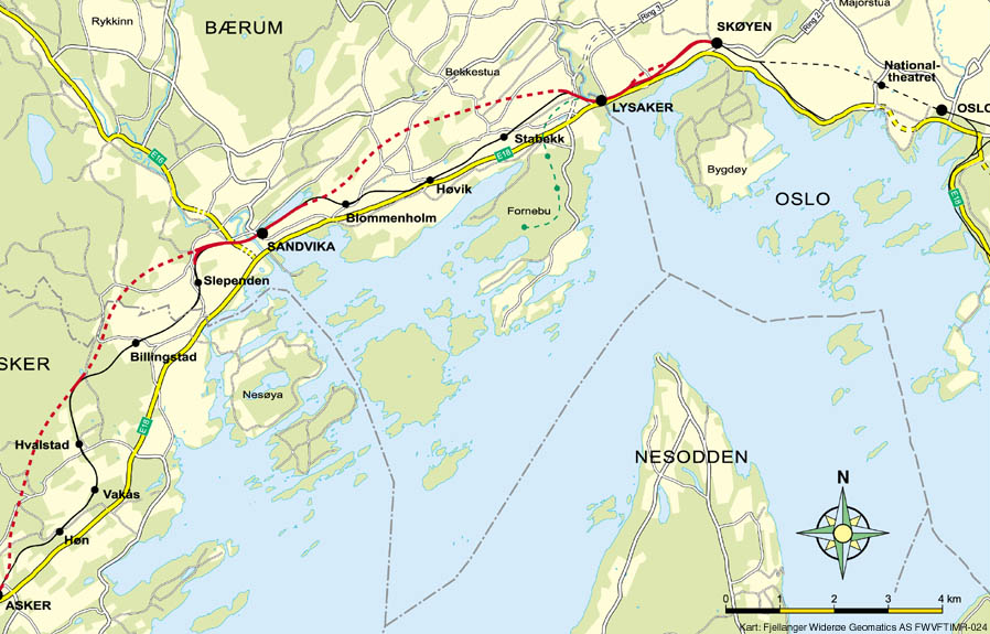
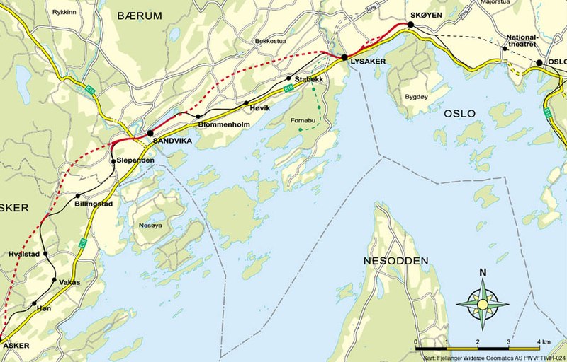
English: Map of the Asker Line west of Oslo, Norway. Red line is the Asker Line and black line is the Drammen Line. Dotted lines are tunnels. Black dots are stations. The green line is the Fornebu Line. The yellow lines indicate European Routes E16 and E18. |
|||
| Bron | http://www.jernbaneverket.no/multimedia/archive/01417/Kart_Sk_yen-Asker_1417793a.jpg | |||
| Auteur | Jernbaneverket / Norwegian National Rail Administration | |||
| Toestemming (Hergebruik van dit bestand) |
|


|
Deze kaartafbeelding zou opnieuw moeten worden aangemaakt als een SVG-bestand door vectorafbeeldingen te gebruiken. Dit heeft een aantal voordelen; zie Commons:Media for cleanup voor meer informatie. Als er een SVG-formaat van deze afbeelding bestaat, dan deze graag uploaden. Nadat u dit heeft gedaan, gelieve dit sjabloon te vervangen door het sjabloon {{vector version available|nieuwe bestandsnaam.svg}} op deze afbeeldingspagina.
|


Bestandsgeschiedenis
Klik op een datum/tijd om het bestand te zien zoals het destijds was.
| Datum/tijd | Miniatuur | Afmetingen | Gebruiker | Opmerking | |
|---|---|---|---|---|---|
| huidige versie | 7 mei 2020 12:56 | | 898 × 575 (129 kB) | Tholme | Cropped 3 % horizontally, 5 % vertically using CropTool with lossless mode. Remove border |
| 18 nov 2008 20:58 |  | 926 × 603 (136 kB) | Arsenikk | {{Information |Description={{en|1=Map of the Asker Line west of Oslo, Norway. Red line is the Asker Line and black line is the Drammen Line. Dotted lines are tunnels. Black dots are stati |
Bestandsgebruik
Dit bestand wordt op de volgende pagina gebruikt:
Globaal bestandsgebruik
De volgende andere wiki's gebruiken dit bestand:
- Gebruikt op da.wikipedia.org
- Gebruikt op de.wikipedia.org
- Gebruikt op en.wikipedia.org
- Gebruikt op fr.wikipedia.org
- Gebruikt op id.wikipedia.org
- Gebruikt op nn.wikipedia.org
- Gebruikt op no.wikipedia.org
- Gebruikt op pl.wikipedia.org
- Gebruikt op sv.wikipedia.org
- Gebruikt op www.wikidata.org