Bestand:Ant-pen-map-Brabant.PNG

Grootte van deze voorvertoning: 436 × 599 pixels. Andere resoluties: 175 × 240 pixels | 349 × 480 pixels | 720 × 989 pixels.
Oorspronkelijk bestand (720 × 989 pixels, bestandsgrootte: 256 kB, MIME-type: image/png)
Dit is een bestand van Wikimedia Commons.
Onderstaande beschrijving komt van de beschrijving van het bestand daar.
Onderstaande beschrijving komt van de beschrijving van het bestand daar.
Beschrijving
| Beschrijving |
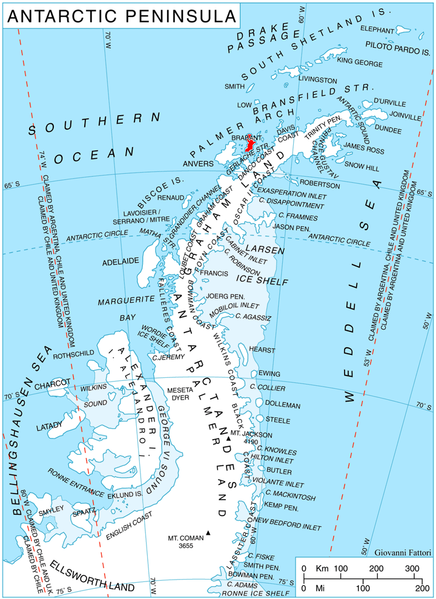
English: Location of Brabant Island, Antarctica. |
| Datum | |
| Bron | Eigen werk, using map File:Ant-pen map.png by Giovanni Fattori. |
| Auteur | Edited by Apcbg |
Licentie
Ik, de auteursrechthebbende van dit werk, maak het hierbij onder de volgende licenties beschikbaar:
Dit bestand is gelicenseerd onder de Creative Commons-licentie Naamsvermelding-Gelijk delen 3.0 Unported
- De gebruiker mag:
- Delen – het werk kopiëren, verspreiden en doorgeven
- Remixen – afgeleide werken maken
- Onder de volgende voorwaarden:
- naamsvermelding – U moet op een gepaste manier aan naamsvermelding doen, een link naar de licentie geven, en aangeven of er wijzigingen in het werk zijn aangebracht. U mag dit op elke redelijke manier doen, maar niet zodanig dat de indruk wordt gewekt dat de licentiegever instemt met uw werk of uw gebruik van zijn werk.
- Gelijk delen – Als u het werk heeft geremixt, veranderd, of erop heeft voortgebouwd, moet u het gewijzigde materiaal verspreiden onder dezelfde licentie als het oorspronkelijke werk, of een daarmee compatibele licentie.

|
Toestemming wordt verleend voor het kopiëren, verspreiden en/of wijzigen van dit document onder de voorwaarden van de GNU-licentie voor vrije documentatie, versie 1.2 of enige latere versie als gepubliceerd door de Free Software Foundation; zonder Invariant Sections, zonder Front-Cover Texts, en zonder Back-Cover Texts. Een kopie van de licentie is opgenomen in de sectie GNU-licentie voor vrije documentatie. |
U mag zelf één van de licenties kiezen.
Bestandsgeschiedenis
Klik op een datum/tijd om het bestand te zien zoals het destijds was.
| Datum/tijd | Miniatuur | Afmetingen | Gebruiker | Opmerking | |
|---|---|---|---|---|---|
| huidige versie | 25 apr 2010 16:32 | | 720 × 989 (256 kB) | Apcbg | {{Information |Description={{en|1=Location of Brabant Island, Antarctica.}} |Source={{own}}, using map File:Ant-pen map.png by Giovanni Fattori. |Author=Edited by Apcbg |Date=2010-04-25 |Permission= |other_versions= }} [[Category:Loca |
Bestandsgebruik
Dit bestand wordt op de volgende pagina gebruikt:
Globaal bestandsgebruik
De volgende andere wiki's gebruiken dit bestand:
- Gebruikt op ar.wikipedia.org
- Gebruikt op az.wikipedia.org
- Gebruikt op bg.wikipedia.org
- Gebruikt op ca.wikipedia.org
- Gebruikt op ceb.wikipedia.org
- Gebruikt op de.wikipedia.org
- Gebruikt op en.wikipedia.org
- Brabant Island
- Lecointe Island
- Mount Hunter (Antarctica)
- Albena Peninsula
- Petroff Point
- Djerassi Glacier
- Pirogov Glacier
- Dimkov Glacier
- Thamyris Glacier
- Rhesus Glacier
- Mitev Glacier
- Kostur Point
- Grigorov Glacier
- Chumerna Glacier
- Mount Cabeza
- Cushing Peak
- Jenner Glacier
- Koch Glacier
- Guyou Bay
- Pare Glacier
- Einthoven Hill
- Pasteur Peninsula
- Galen Peak
- Harvey Heights (Antarctica)
- Hippocrates Glacier
- Hill Bay
- Mackenzie Glacier
- Malpighi Glacier
- Solvay Mountains
- Kayak Bay
- Rush Glacier
- Laënnec Glacier
- Lanusse Bay
- Lister Glacier (Palmer Archipelago)
- Eastern Dallmann Bay Antarctic Specially Protected Area
- Paprat Peak
- Kondolov Peak
- Sheynovo Peak
- Zabel Point
- Devene Point
Globaal gebruik van dit bestand bekijken.