Bestand:Anglo American War 1812 Locations map-fr.svg

Afmetingen van deze voorvertoning van het type PNG van dit SVG-bestand: 800 × 444 pixels Andere resoluties: 320 × 178 pixels | 640 × 356 pixels | 1.024 × 569 pixels | 1.280 × 711 pixels | 2.560 × 1.422 pixels | 1.494 × 830 pixels.
Oorspronkelijk bestand (SVG-bestand, nominaal 1.494 × 830 pixels, bestandsgrootte: 206 kB)
| Dit is een bestand van Wikimedia Commons. Onderstaande beschrijving komt van de beschrijving van het bestand daar. |
Beschrijving
| Beschrijving |
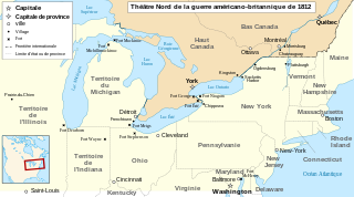
English: Main locations of the War of 1812 between the United States and the United Kingdom Français : Principaux théâtres d'opérations de la Guerre de 1812 entre les États-Unis et le Royaume-Uni. Español: Principales teatros de operaciones de la Guerra de 1812 entre los Estados Unidos y el Reino Unido. Català: Principals escenaris de la Guerra de 1812-1815 entre els Estats Units d'Amèrica i el Regne Unit. |
| Datum | |
| Bron |
travail personnel (own work). Sources :
|
| Auteur | Sémhur |
| Andere versies |
Afgeleide werken van dit bestand: Anglo American War 1812 Locations map-en.svg
|

| Cameralocatie | | Deze en andere afbeeldingen in: OpenStreetMap |
|---|

|
Dit SVG-bestand maakt gebruik van geïntegreerde tekst die gemakkelijk kan worden vertaald naar uw taal met een SVG editor, een tekstverwerker of het hulpmiddel SVG Translate. Uitleg |
Deze niet W3C-verklaarde vectorafbeelding is gemaakt met Inkscape .
Licentie
Ik, de auteursrechthebbende van dit werk, maak het hierbij onder de volgende licenties beschikbaar:

|
Toestemming wordt verleend voor het kopiëren, verspreiden en/of wijzigen van dit document onder de voorwaarden van de GNU-licentie voor vrije documentatie, versie 1.2 of enige latere versie als gepubliceerd door de Free Software Foundation; zonder Invariant Sections, zonder Front-Cover Texts, en zonder Back-Cover Texts. Een kopie van de licentie is opgenomen in de sectie GNU-licentie voor vrije documentatie. |
Dit bestand is gelicenseerd onder de Creative Commons-licenties Naamsvermelding-Gelijk delen 3.0 Unported, 2.5 Algemeen, 2.0 Algemeen en 1.0 Algemeen.
- De gebruiker mag:
- Delen – het werk kopiëren, verspreiden en doorgeven
- Remixen – afgeleide werken maken
- Onder de volgende voorwaarden:
- naamsvermelding – U moet op een gepaste manier aan naamsvermelding doen, een link naar de licentie geven, en aangeven of er wijzigingen in het werk zijn aangebracht. U mag dit op elke redelijke manier doen, maar niet zodanig dat de indruk wordt gewekt dat de licentiegever instemt met uw werk of uw gebruik van zijn werk.
- Gelijk delen – Als u het werk heeft geremixt, veranderd, of erop heeft voortgebouwd, moet u het gewijzigde materiaal verspreiden onder dezelfde licentie als het oorspronkelijke werk, of een daarmee compatibele licentie.
U mag zelf één van de licenties kiezen.
Bestandsgeschiedenis
Klik op een datum/tijd om het bestand te zien zoals het destijds was.
| Datum/tijd | Miniatuur | Afmetingen | Gebruiker | Opmerking | |
|---|---|---|---|---|---|
| huidige versie | 22 sep 2023 12:43 | | 1.494 × 830 (206 kB) | Lalpino | File uploaded using svgtranslate tool (https://svgtranslate.toolforge.org/). Added translation for ca. |
| 21 jun 2008 01:26 |  | 1.494 × 830 (151 kB) | MaCRoEco | {{Information |Description= |Source= |Date= |Author= |Permission= |other_versions= }} | |
| 17 jun 2008 18:04 |  | 1.494 × 830 (160 kB) | Sémhur | Mistake : Fort Henry => Fort McHenry | |
| 17 jun 2008 11:50 |  | 1.494 × 830 (159 kB) | Sémhur | {{Information |Description={{en|1=Main locations of the War of 1812 between the United States and the United Kingdom}} {{fr|1=Principaux théâtres d'opérations de la Guerre de 1812 entre les États-Unis et le R |
Bestandsgebruik
Dit bestand wordt op de volgende pagina gebruikt:
Globaal bestandsgebruik
De volgende andere wiki's gebruiken dit bestand:
- Gebruikt op ca.wikipedia.org
- Gebruikt op fr.wikipedia.org