Bestand:AlbanyCounty Map 2.svg

Afmetingen van deze voorvertoning van het type PNG van dit SVG-bestand: 766 × 594 pixels Andere resoluties: 310 × 240 pixels | 619 × 480 pixels | 991 × 768 pixels | 1.280 × 993 pixels | 2.560 × 1.985 pixels.
Oorspronkelijk bestand (SVG-bestand, nominaal 766 × 594 pixels, bestandsgrootte: 163 kB)
| Dit is een bestand van Wikimedia Commons. Onderstaande beschrijving komt van de beschrijving van het bestand daar. |
Beschrijving
| Beschrijving |
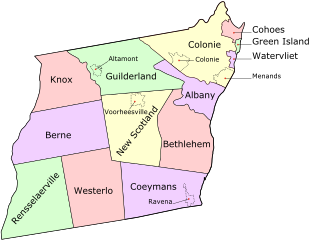
English: Map of Albany County, New York, United States showing its constituent cities, towns, and villages |
| Datum | |
| Bron | Eigen werk |
| Auteur | UpstateNYer and ZooFari |
This Scalable Vector Graphic was made or vectorized by ZooFari using Inkscape (see all SVGs and images).
Licentie
Dit bestand is gelicenseerd onder de Creative Commons-licentie Naamsvermelding 3.0 Unported
- De gebruiker mag:
- Delen – het werk kopiëren, verspreiden en doorgeven
- Remixen – afgeleide werken maken
- Onder de volgende voorwaarden:
- naamsvermelding – U moet op een gepaste manier aan naamsvermelding doen, een link naar de licentie geven, en aangeven of er wijzigingen in het werk zijn aangebracht. U mag dit op elke redelijke manier doen, maar niet zodanig dat de indruk wordt gewekt dat de licentiegever instemt met uw werk of uw gebruik van zijn werk.
Bestandsgeschiedenis
Klik op een datum/tijd om het bestand te zien zoals het destijds was.
| Datum/tijd | Miniatuur | Afmetingen | Gebruiker | Opmerking | |
|---|---|---|---|---|---|
| huidige versie | 5 mei 2010 03:17 | | 766 × 594 (163 kB) | ZooFari | == {{int:filedesc}} == {{Information |Description={{en|Map of Albany County, New York, United States showing its constituent cities, [ |
Bestandsgebruik
Dit bestand wordt op de volgende pagina gebruikt:
Globaal bestandsgebruik
De volgende andere wiki's gebruiken dit bestand:
- Gebruikt op ca.wikipedia.org
- Gebruikt op en.wikipedia.org
- Gebruikt op en.wikivoyage.org
- Gebruikt op fr.wikipedia.org
- Gebruikt op ja.wikipedia.org
- Gebruikt op ku.wikipedia.org
- Gebruikt op pt.wikipedia.org