Bestand:Agricultural Fields near Perdizes, Minas Gerais, Brazil.JPG

Grootte van deze voorvertoning: 800 × 532 pixels. Andere resoluties: 320 × 213 pixels | 640 × 425 pixels | 1.024 × 681 pixels | 1.280 × 851 pixels | 2.560 × 1.701 pixels | 4.288 × 2.850 pixels.
Oorspronkelijk bestand (4.288 × 2.850 pixels, bestandsgrootte: 2,83 MB, MIME-type: image/jpeg)
Dit is een bestand van Wikimedia Commons.
Onderstaande beschrijving komt van de beschrijving van het bestand daar.
Onderstaande beschrijving komt van de beschrijving van het bestand daar.
Beschrijving
| Beschrijving |
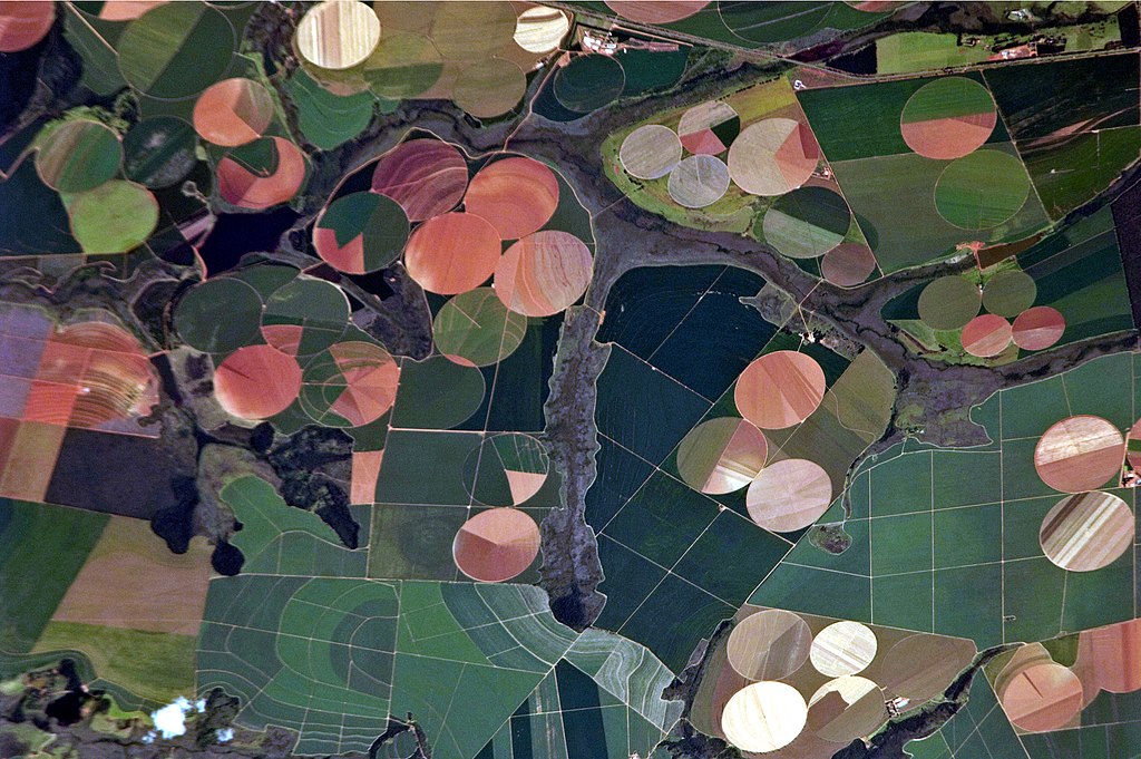
English: This astronaut photograph illustrates the diverse agricultural landscape in the western part of Minas Gerais state in Brazil. The fields in this image are located south-west of the city of Perdizes, which means “partridges” in Portuguese. A mix of regularly-gridded polygonal fields and circular centre-pivot fields marks the human use of the region. Small streams (and their adjacent floodplains) of the Araguari River extend like fingers throughout the landscape. – The visual diversity of the field forms is matched by the variety of crops: sunflowers, wheat, potatoes, coffee, rice, soybeans, and corn are among the products of the region. While the Northern Hemisphere is still in the grip of winter, crops are growing in the Southern Hemisphere, as indicated by the many green fields. Fallow fields—not in active agricultural use—display the violet, reddish, and light tan soils common to this part of Brazil. Darker soils are often rich in iron and aluminum oxides, and are typical of highly weathered soil that forms in hot, humid climates. |
| Datum | |
| Bron |
English: NASA Earth Observatory – Image acquired with a Nikon D2Xs digital camera using an 800 mm lens, and is provided by the ISS Crew Earth Observations experiment and Image Science & Analysis Laboratory, Johnson Space Center. |
| Auteur | ISS Expedition 26 crew |
| Cameralocatie | | Deze en andere afbeeldingen in: OpenStreetMap |
|---|
Deze afbeelding of video is gecatalogiseerd door Johnson Space Center van de Verenigde Staten National Aeronautics and Space Administration (NASA)onder Foto ID: ISS026-E-25373.Deze banner zegt niets over de auteursrechten die van toepassing zijn. Een normale auteursrechten-tag is nodig. Zie Commons:Licensing voor meer informatie. Andere talen:
|
Licentie
This file is in the public domain in the United States because it was created by the Image Science & Analysis Laboratory, of the NASA Johnson Space Center. NASA copyright policy states that "NASA material is not protected by copyright unless noted". (NASA media use guidelines or Conditions of Use of Astronaut Photographs).
Photo source: ISS026-E-25373.
|
| Aantekeningen | Deze afbeelding is aangetekend: Bekijk de aantekeningen op Commons |
Bestandsgeschiedenis
Klik op een datum/tijd om het bestand te zien zoals het destijds was.
| Datum/tijd | Miniatuur | Afmetingen | Gebruiker | Opmerking | |
|---|---|---|---|---|---|
| huidige versie | 15 dec 2014 19:46 | | 4.288 × 2.850 (2,83 MB) | ArionStar | Reverted to version as of 12:59, 21 February 2011 |
| 10 dec 2014 16:38 |  | 2.629 × 1.994 (1,1 MB) | ArionStar | Lower resolution but better quality | |
| 10 dec 2014 16:30 |  | 2.616 × 2.028 (1,14 MB) | ArionStar | Lower resolution but better quality | |
| 21 feb 2011 14:59 |  | 4.288 × 2.850 (2,83 MB) | Originalwana | {{Information |Description ={{en|1=This astronaut photograph illustrates the diverse agricultural landscape in the western part of Minas Gerais state in Brazil. The fields in this image are located south-west of the city of [[:Category:Perdizes|Perdize |
Bestandsgebruik
Dit bestand wordt op de volgende pagina gebruikt:
Globaal bestandsgebruik
De volgende andere wiki's gebruiken dit bestand:
- Gebruikt op bg.wikipedia.org
- Gebruikt op el.wikipedia.org
- Gebruikt op en.wikipedia.org
- Gebruikt op eu.wikipedia.org
- Gebruikt op fr.wikipedia.org
- Gebruikt op pt.wikipedia.org