Bestand:Adare Peninsula map.jpg
Grootte van deze voorvertoning: 463 × 599 pixels. Andere resoluties: 185 × 240 pixels | 371 × 480 pixels | 594 × 768 pixels | 792 × 1.024 pixels | 1.475 × 1.908 pixels.
Oorspronkelijk bestand (1.475 × 1.908 pixels, bestandsgrootte: 769 kB, MIME-type: image/jpeg)
| Dit is een bestand van Wikimedia Commons. Onderstaande beschrijving komt van de beschrijving van het bestand daar. |
Beschrijving
| Beschrijving |
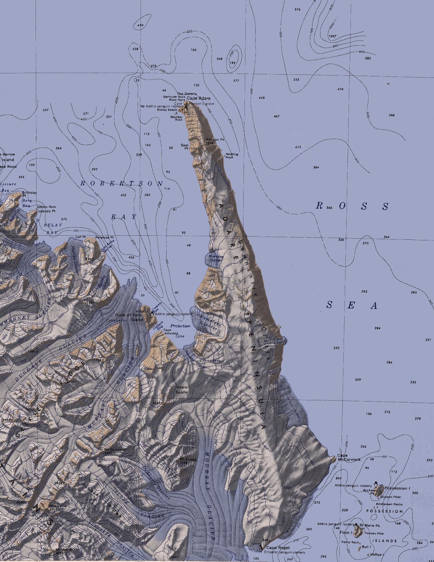
English: Map of the Adare Peninsula west of the Ross Sea. |
| Datum | |
| Bron | File:C71188s5 Ant.Map Cape Adare.jpg |
| Auteur | U. S. Geological Survey |
Licentie
Deze afbeelding bevindt zich in het publiek domein omdat het materiaal bevat dat oorspronkelijk afkomstig is van de United States Geological Survey, een agentschap van de United States Department of the Interior. Voor meer informatie, zie het officiële USGS-auteursrechtenbeleid
|
Bestandsgeschiedenis
Klik op een datum/tijd om het bestand te zien zoals het destijds was.
| Datum/tijd | Miniatuur | Afmetingen | Gebruiker | Opmerking | |
|---|---|---|---|---|---|
| huidige versie | 11 mrt 2010 23:51 | | 1.475 × 1.908 (769 kB) | 4ing | == {{int:filedesc}} == {{Information |Description={{en|1=Map of Possession Islands in the Ross Sea.}} |Source=File:C71188s5 Ant.Map Cape Adare.jpg |Author=U. S. Geological Survey |Date=1968 |Permission= |other_versions= }} <!--{{ImageUpload|basic}}- |
Bestandsgebruik
Dit bestand wordt op de volgende pagina gebruikt:
Globaal bestandsgebruik
De volgende andere wiki's gebruiken dit bestand:
- Gebruikt op be.wikipedia.org
- Gebruikt op ceb.wikipedia.org
- Gebruikt op da.wikipedia.org
- Gebruikt op de.wikipedia.org
- Transantarktisches Gebirge
- Kap Adare
- Adare-Halbinsel
- Kap Roget
- Robertson Bay
- Adare Saddle
- Newnes-Gletscher
- Moubray-Gletscher
- Protection Cove
- Colbeck Bay
- Herzog-von-York-Insel
- Murray-Gletscher
- Dugdale-Gletscher
- Geikie Ridge
- Archer Peak
- Possession Island (Antarktika)
- Possession Islands
- Kap McCormick
- Berg Bay
- Burnette-Gletscher
- Boulder Rock
- Ridley Beach
- Bull Island (Antarktika)
- Kemp Rock
- Heftye Island
- Foyn Island
- Crescent Bay
- DeAngelo-Gletscher
- Mount Robinson (Viktorialand)
- Mount Ruegg
- Dickson Pillar
- Downshire-Kliffs
- Favreau Pillar
- Gertrude Rock
- Rose Rock
- Hanson Peak
- Hargreaves Peak
- Nameless Glacier
- Kristensen Rocks
- Nestling Rock
- Seal Point (Viktorialand)
Globaal gebruik van dit bestand bekijken.