Bestand:Acre Municip Brasileia.svg

Afmetingen van deze voorvertoning van het type PNG van dit SVG-bestand: 800 × 449 pixels Andere resoluties: 320 × 180 pixels | 640 × 359 pixels | 1.024 × 575 pixels | 1.280 × 718 pixels | 2.560 × 1.437 pixels | 1.194 × 670 pixels.
Oorspronkelijk bestand (SVG-bestand, nominaal 1.194 × 670 pixels, bestandsgrootte: 385 kB)
| Dit is een bestand van Wikimedia Commons. Onderstaande beschrijving komt van de beschrijving van het bestand daar. |

|
Standardization of derivative maps
Feel free to create derivations of this work, but if you want to illustrate a Wikipedia article with derivative works of this or similar maps of Brazil, please strictly follow the visual standard, nomenclature and classification already in use. All maps of Brazilian subdivisions are being adaptated or created in this way. We do not want to inhibit creativity but the pattern adopted here was presented and accepted by the Lusophone community and should be followed whenever possible. |
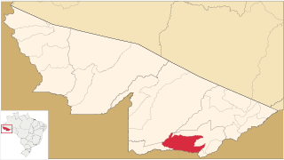
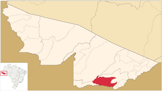
| Beschrijving | Mapa de localização do Município de Brasiléia no Estado do Acre, Brasil./ Map locator of Acre's Brasiléia city, Brazil. | ||||||||
| Datum | |||||||||
| Bron | Image:Acre_MesoMicroMunicip.svg, Raphael Lorenzeto de Abreu | ||||||||
| Auteur | own work | ||||||||
| Toestemming (Hergebruik van dit bestand) |
Ik, de auteursrechthebbende van dit werk, maak het hierbij onder de volgende licenties beschikbaar:
Dit bestand is gelicenseerd onder de Creative Commons-licentie Naamsvermelding 2.5 Unported
U mag zelf één van de licenties kiezen. |

Bestandsgeschiedenis
Klik op een datum/tijd om het bestand te zien zoals het destijds was.
| Datum/tijd | Miniatuur | Afmetingen | Gebruiker | Opmerking | |
|---|---|---|---|---|---|
| huidige versie | 9 aug 2006 06:16 | | 1.194 × 670 (385 kB) | Srfortes | |
| 9 aug 2006 06:06 |  | 1.194 × 670 (385 kB) | Srfortes | {{User:Raphael.lorenzeto/DerivativeMaps}} {{Information| |Description=Mapa de localização do Município de Brasiléia no Estado do Acre, Brasil./ Map locator of Acre's Brasiléia city, Brazil. |Source=Image:Acre_MesoMicroMunicip.svg, [[User:Raphael |
Bestandsgebruik
Dit bestand wordt op de volgende pagina gebruikt:
Globaal bestandsgebruik
De volgende andere wiki's gebruiken dit bestand:
- Gebruikt op bg.wikipedia.org
- Gebruikt op bpy.wikipedia.org
- Gebruikt op ceb.wikipedia.org
- Gebruikt op de.wikipedia.org
- Gebruikt op en.wikipedia.org
- Gebruikt op eo.wikipedia.org
- Gebruikt op es.wikipedia.org
- Gebruikt op eu.wikipedia.org
- Gebruikt op fa.wikipedia.org
- Gebruikt op fr.wikipedia.org
- Gebruikt op id.wikipedia.org
- Gebruikt op it.wikipedia.org
- Gebruikt op ka.wikipedia.org
- Gebruikt op ky.wikipedia.org
- Gebruikt op lez.wikipedia.org
- Gebruikt op li.wikipedia.org
- Gebruikt op no.wikipedia.org
- Gebruikt op pt.wikipedia.org
- Gebruikt op pt.wikivoyage.org
- Gebruikt op pt.wiktionary.org
- Gebruikt op ro.wikipedia.org
- Gebruikt op ru.wikipedia.org
- Gebruikt op sv.wikipedia.org
- Gebruikt op tr.wikipedia.org
- Gebruikt op tt.wikipedia.org
- Gebruikt op vi.wikipedia.org
- Gebruikt op www.wikidata.org
- Gebruikt op zh-min-nan.wikipedia.org
- Gebruikt op zh.wikipedia.org