Bestand:A38 UK road map.svg

Afmetingen van deze voorvertoning van het type PNG van dit SVG-bestand: 494 × 600 pixels Andere resoluties: 198 × 240 pixels | 395 × 480 pixels | 633 × 768 pixels | 843 × 1.024 pixels | 1.687 × 2.048 pixels | 1.108 × 1.345 pixels.
Oorspronkelijk bestand (SVG-bestand, nominaal 1.108 × 1.345 pixels, bestandsgrootte: 2,22 MB)
Dit is een bestand van Wikimedia Commons.
Onderstaande beschrijving komt van de beschrijving van het bestand daar.
Onderstaande beschrijving komt van de beschrijving van het bestand daar.
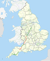
| Beschrijving | Map showing the route of the A38 in England. The green sections are parts designated as a primary route, the red sections are parts that are not primary. The blue section is the A38(M) motorway. Other motorways and primary routes are shown in a paler colours and the background map shows English ceremonial counties. |
| Datum | |
| Bron |
National Geospatial-Intelligence Agency
|
| Auteur | Nilfanion, using Ordnance Survey data |
| Toestemming (Hergebruik van dit bestand) |
Dit bestand is gelicenseerd onder de Creative Commons-licentie Naamsvermelding-Gelijk delen 3.0 Unported Naamsvermelding: Contains Ordnance Survey data © Crown copyright and database right
|
Bestandsgeschiedenis
Klik op een datum/tijd om het bestand te zien zoals het destijds was.
| Datum/tijd | Miniatuur | Afmetingen | Gebruiker | Opmerking | |
|---|---|---|---|---|---|
| huidige versie | 23 nov 2010 18:40 | | 1.108 × 1.345 (2,22 MB) | Nilfanion | thicker county lines , fix coast |
| 20 nov 2010 01:26 |  | 1.108 × 1.345 (2,21 MB) | Nilfanion | thicken line | |
| 20 nov 2010 01:15 |  | 1.108 × 1.345 (2,21 MB) | Nilfanion | {{Information |Description=Map showing the route of the A38 in England. The green sections are parts designated as a primary route, the red sections are parts that are not primary. The blue section is the w:A38(M) motorway. Other motor |
Bestandsgebruik
Dit bestand wordt op de volgende 2 pagina's gebruikt:
Globaal bestandsgebruik
De volgende andere wiki's gebruiken dit bestand: