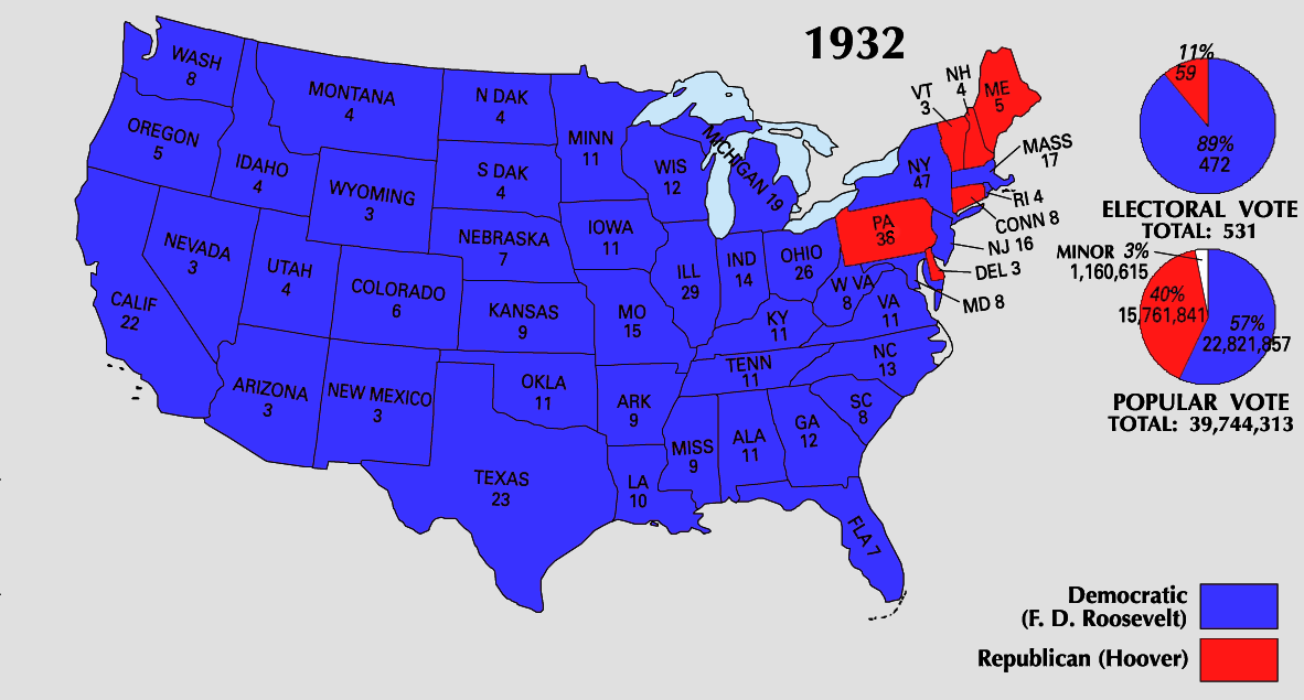
Bestand:1932 Electoral Map.png
Grootte van deze voorvertoning: 800 × 430 pixels. Andere resoluties: 320 × 172 pixels | 640 × 344 pixels | 1.182 × 635 pixels.
Oorspronkelijk bestand (1.182 × 635 pixels, bestandsgrootte: 169 kB, MIME-type: image/png)
Dit is een bestand van Wikimedia Commons.
Onderstaande beschrijving komt van de beschrijving van het bestand daar.
Onderstaande beschrijving komt van de beschrijving van het bestand daar.

|
Bestand:1932 electoral map.svg is een vectorversie van dit bestand. Indien niet van slechtere kwaliteit dient deze gebruikt te worden in plaats van deze rasterafbeelding.
File:1932 Electoral Map.png → File:1932 electoral map.svg
Zie Help:SVG voor meer informatie. |
 |
This map was obtained from an edition of the National Atlas of the United States. Like almost all works of the U.S. federal government, works from the National Atlas are in the public domain in the United States.
Online access: NationalAtlas.gov | 1970 print edition: Library of Congress, Perry-Castañeda Library
|
| U.S. presidential election maps from the National Atlas of the United States |
| See also: SVG maps |
| 1789 · 1792 · 1796 · 1800 · 1804 · 1808 · 1812 · 1816 · 1820 · 1824 · 1828 · 1832 · 1836 · 1840 · 1844 · 1848 · 1852 · 1856 · 1860 · 1864 · 1868 · 1872 · 1876 · 1880 · 1884 · 1888 · 1892 · 1896 · 1900 · 1904 · 1908 · 1912 · 1916 · 1920 · 1924 · 1928 · 1932 · 1936 · 1940 · 1944 · 1948 · 1952 · 1956 · 1960 · 1964 · 1968 · 1972 · 1976 · 1980 · 1984 · 1988 · 1992 · 1996 · 2000 · 2004 |
Bestandsgeschiedenis
Klik op een datum/tijd om het bestand te zien zoals het destijds was.
| Datum/tijd | Miniatuur | Afmetingen | Gebruiker | Opmerking | |
|---|---|---|---|---|---|
| huidige versie | 26 jun 2008 00:09 | | 1.182 × 635 (169 kB) | Tallicfan20 | better |
| 11 jun 2008 23:03 |  | 1.182 × 635 (147 kB) | Tallicfan20 | ||
| 24 mei 2008 10:56 |  | 1.182 × 635 (136 kB) | Tallicfan20 | better colors | |
| 16 mei 2008 21:21 |  | 1.182 × 635 (96 kB) | Tallicfan20 | ||
| 16 mei 2008 21:19 |  | 1.182 × 635 (96 kB) | Tallicfan20 | {{PD-USGov-Atlas}} |
Bestandsgebruik
Geen enkele pagina gebruikt dit bestand.
Globaal bestandsgebruik
De volgende andere wiki's gebruiken dit bestand:
- Gebruikt op de.wikipedia.org
- Gebruikt op en.wikipedia.org
- Gebruikt op hu.wikipedia.org
- Gebruikt op it.wikipedia.org