Bestand:1842 S.D.U.K. Map of the City of Calcutta, India - Geographicus - Calcutta-sduk-1842.jpg
Oorspronkelijk bestand (3.500 × 2.800 pixels, bestandsgrootte: 2,45 MB, MIME-type: image/jpeg)
Onderstaande beschrijving komt van de beschrijving van het bestand daar.
| Titel |
Calcutta. |
|||||||||
| Beschrijving |
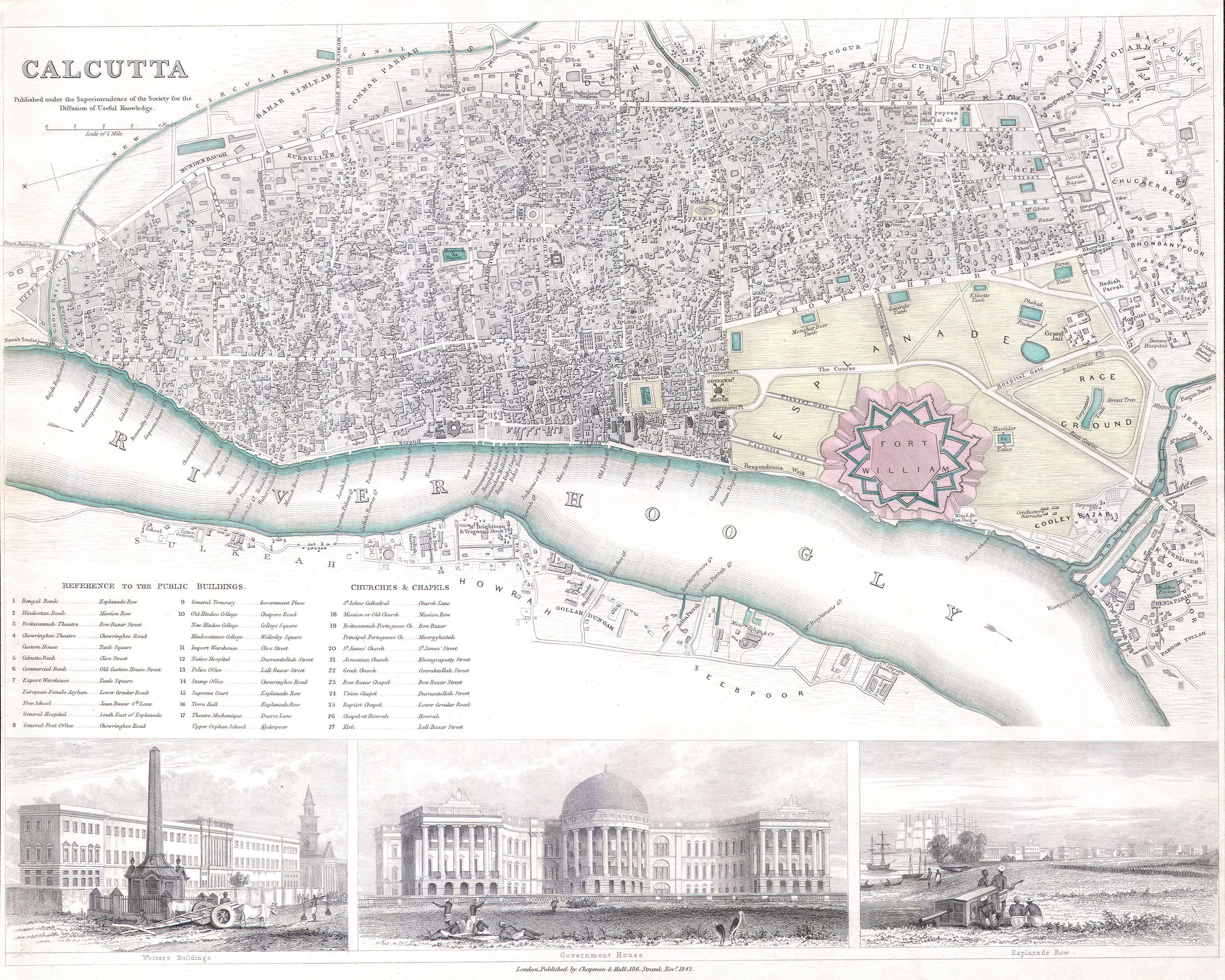
English: This is a S.D.U.K. map or city plan of Calcutta, India. Calcutta was once the administrative capital of British India. The lower part of the map is decorated by several beautiful engraved illustrations of important Calcutta locations, including the Government House, Esplande Row, and the Writer’s Buildings. As much as possible individual streets are indicated as are souks and bazaars. Published by “Chapman and Hall of 186 Strand Street in November of 1842”. |
|||||||||
| Datum | ||||||||||
| Bron |
Maps of the Society for the Diffusion of Useful Knowledge. Vol1. 1844.
|
|||||||||
| Maker | ||||||||||
| Geotemporal data | ||||||||||
| Bounding box |
|
|||||||||
| Georeferencing | ||||||||||
| Archival data | ||||||||||
| Inventarisnummer |
Geographicus link: Calcutta-sduk-1842 |
|||||||||
| Afmetingen | hoogte: 12,5 in (31,7 cm); breedte: 16 in (40,6 cm) | |||||||||
| Andere versies | ||||||||||
.jpg)


.jpg)
Licentie
|
Het tweedimensionale kunstwerk afgebeeld op deze afbeelding valt in het publiek domein omdat:
Reproducties van het werk kunnen ook worden beschouwd als publiek domein omdat ze geen oorspronkelijk karakter hebben. Dit geldt voor reproducties gemaakt in de Verenigde Staten (zie Bridgeman Art Library v. Corel Corp.), Duitsland en veel andere landen.
| ||||

|
Deze afbeelding is beoordeeld op basis van de criteria voor waardevolle afbeeldingen en wordt beschouwd als de meest waardevolle afbeelding op Commons binnen het onderwerpgebied: Old maps of Kolkata from 1842.. Deze nominatie kan bekeken worden op Commons:Valued image candidates/1842 S.D.U.K. Map of the City of Calcutta, India - Geographicus - Calcutta-sduk-1842.jpg. |
Deze afbeelding is beoordeeld aan de hand van de richtlijnen voor Kwaliteitsafbeeldingen en wordt beschouwd als een Kwaliteitsafbeelding.
|
Bestandsgeschiedenis
Klik op een datum/tijd om het bestand te zien zoals het destijds was.
| Datum/tijd | Miniatuur | Afmetingen | Gebruiker | Opmerking | |
|---|---|---|---|---|---|
| huidige versie | 25 mrt 2011 03:31 | | 3.500 × 2.800 (2,45 MB) | BotMultichillT | {{subst:User:Multichill/Geographicus |link=http://www.geographicus.com/P/AntiqueMap/Calcutta-sduk-1842 |product_name=1842 S.D.U.K. Map of the City of Calcutta, India |map_title=Calcutta. |description=This is a S.D.U.K. map or city plan of Calcutta, India. |
Bestandsgebruik
Geen enkele pagina gebruikt dit bestand.