Bestand:Map of Colchis, Iberia, Albania, and the neighbouring countries ca 1770.jpg

Grootte van deze voorvertoning: 800 × 598 pixels. Andere resoluties: 320 × 239 pixels | 640 × 479 pixels | 1.016 × 760 pixels.
Oorspronkelijk bestand (1.016 × 760 pixels, bestandsgrootte: 194 kB, MIME-type: image/jpeg)
| Dit is een bestand van Wikimedia Commons. Onderstaande beschrijving komt van de beschrijving van het bestand daar. |
Beschrijving
| Beschrijving |
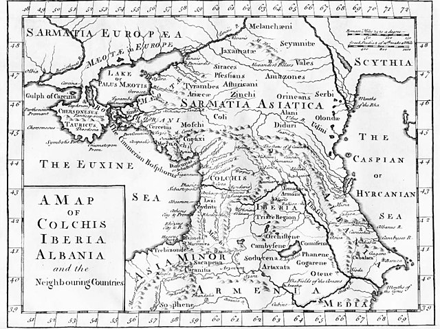
English: "A Map of Colchis, Iberia, Albania, and the neighbouring countries". A map of the Caucasus / Crimea (Chersonesus Tauricus)/ southern Russia region during classical antiquity (the ancient period). Note that the "Albania" referred to was on the Caspian Sea (not the modern Albania in the Balkans). Copper-engraved map, no publisher or date, London, ca 1770 (or 1729?).
Deutsch: Kaukasus mit Siedlungsgebieten von Sarmaten und Amazonen in der Antike, Kupferstich von ca. 1770
Français : La Colchide, l’Ibérie (orientale), l’Albanie (orientale) et les régions voisines
ქართული: ანტიკური ხანის კოლხეთი, ბერძნულ წყაროებზე დაყრდნობით, დაბეჭდილია ლონდონში, 1770.
Nederlands: Kaart van de Kaukasus, ca. 1770
Русский: «Европейская Сарматия». Карта основана на греческих литературных источниках, напечатана в Лондоне в 1770 |
| Datum | ca. 1770 |
| Bron |
|
| Auteur | last upload en:User:AnonMoos |
Licentie
|
Het tweedimensionale kunstwerk afgebeeld op deze afbeelding valt in het publiek domein omdat:
Reproducties van het werk kunnen ook worden beschouwd als publiek domein omdat ze geen oorspronkelijk karakter hebben. Dit geldt voor reproducties gemaakt in de Verenigde Staten (zie Bridgeman Art Library v. Corel Corp.), Duitsland en veel andere landen.
| ||||
Oorspronkelijk uploadlogboek
File upload history on en:
- 20:53, 27 October 2005 . . AnonMoos (Talk) . . 1016x760 (198173 bytes) (Version of image losslessly cropped to region of interest with Jpegcrop program. )
- 20:32, 3 July 2005 . . PANONIAN (Talk) . . 1254x760 (224060 bytes) (historic map )
| date/time | username | resolution | size | edit summary | |
|---|---|---|---|---|---|
| 14:53, 29 December 2005 | User:Ustas | <a href="http://upload.wikimedia.org/wikipedia/commons/d/df/1729.jpg"><img alt="Thumbnail for version as of 14:53, 29 December 2005" src="http://upload.wikimedia.org/wikipedia/commons/thumb/d/df/1729.jpg/120px-1729.jpg" width="120" height="90" border="0" /></a> | 1,016×760 | 194 KB | {{Information |Description = Copper-engraved map, no publisher or date, London, ca 1770. |Source = <a href="http://en.wikipedia.org/wiki/Image:1729.jpg" class="extiw" title="en:Image:1729.jpg">en:Image:1729.jpg</a>, [http://www.village-atlas.com/ancient/ancient.html] |Date = |Author = last upload <a href="http://en.wikipedia.org/wiki/User:AnonMoos" class="extiw" title="en:User:AnonMoos">en:User:AnonMoos</a> |Permission = PD |other_ver |
Bestandsgeschiedenis
Klik op een datum/tijd om het bestand te zien zoals het destijds was.
| Datum/tijd | Miniatuur | Afmetingen | Gebruiker | Opmerking | |
|---|---|---|---|---|---|
| huidige versie | 22 okt 2008 18:02 | | 1.016 × 760 (194 kB) | BetacommandBot | move approved by: User:Deadstar This image was moved from Image:1729.jpg {{Information |Description = "A Map of Colchis, Iberia, Albania, and the neighbouring countries". A map of the Caucasus / Crimea / southern Russia region during classical |
Bestandsgebruik
Dit bestand wordt op de volgende 5 pagina's gebruikt:
Globaal bestandsgebruik
De volgende andere wiki's gebruiken dit bestand:
- Gebruikt op als.wikipedia.org
- Gebruikt op an.wikipedia.org
- Gebruikt op ar.wikipedia.org
- Gebruikt op az.wikipedia.org
- Gebruikt op ba.wikipedia.org
- Gebruikt op bn.wikipedia.org
- Gebruikt op ca.wikipedia.org
- Gebruikt op co.wikipedia.org
- Gebruikt op cy.wikipedia.org
- Gebruikt op da.wikipedia.org
- Gebruikt op de.wikipedia.org
- Gebruikt op el.wikipedia.org
- Gebruikt op en.wikipedia.org
- Gebruikt op es.wikipedia.org
- Gebruikt op eu.wikipedia.org
- Gebruikt op fa.wikipedia.org
- Gebruikt op fi.wikipedia.org
- Gebruikt op fr.wikipedia.org
- Gebruikt op fy.wikipedia.org
- Gebruikt op gl.wikipedia.org
- Gebruikt op he.wikipedia.org
- Gebruikt op hr.wikipedia.org
- Gebruikt op hu.wikipedia.org
- Gebruikt op hyw.wikipedia.org
- Gebruikt op it.wikipedia.org
Globaal gebruik van dit bestand bekijken.