Bestand:Zayyanids1300-1500.png

Grootte van deze voorvertoning: 800 × 490 pixels. Andere resoluties: 320 × 196 pixels | 640 × 392 pixels | 858 × 526 pixels.
Oorspronkelijk bestand (858 × 526 pixels, bestandsgrootte: 18 kB, MIME-type: image/png)
| Dit is een bestand van Wikimedia Commons. Onderstaande beschrijving komt van de beschrijving van het bestand daar. |
Beschrijving
| Beschrijving |
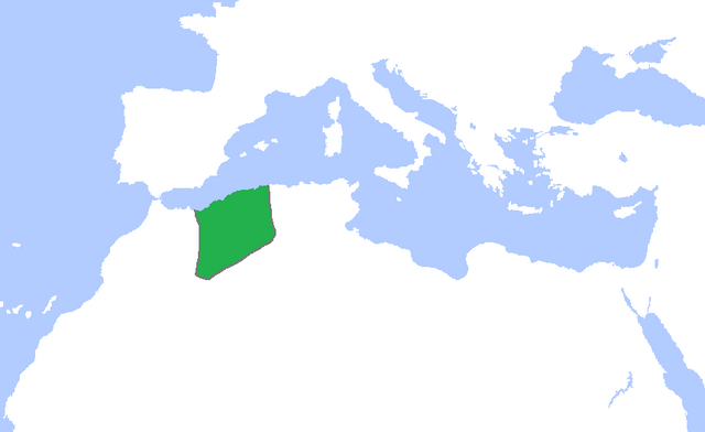
English: Locator map of the lands ruled by the Zayyanid/Abdalwadid dynasty, c. 1300-1500.
(Partially based on Atlas of World History (2007) - The World 1200-1300, 1300-1400, 1400-1500 map) |
| Datum | |
| Bron | Eigen werk |
| Auteur | Gabagool |
Licentie
Ik, de auteursrechthebbende van dit werk, maak het hierbij onder de volgende licentie beschikbaar:
Dit bestand is gelicenseerd onder de Creative Commons-licentie Naamsvermelding 3.0 Unported
- De gebruiker mag:
- Delen – het werk kopiëren, verspreiden en doorgeven
- Remixen – afgeleide werken maken
- Onder de volgende voorwaarden:
- naamsvermelding – U moet op een gepaste manier aan naamsvermelding doen, een link naar de licentie geven, en aangeven of er wijzigingen in het werk zijn aangebracht. U mag dit op elke redelijke manier doen, maar niet zodanig dat de indruk wordt gewekt dat de licentiegever instemt met uw werk of uw gebruik van zijn werk.
Bestandsgeschiedenis
Klik op een datum/tijd om het bestand te zien zoals het destijds was.
| Datum/tijd | Miniatuur | Afmetingen | Gebruiker | Opmerking | |
|---|---|---|---|---|---|
| huidige versie | 7 nov 2022 02:24 | | 858 × 526 (18 kB) | Mouath14 | Editor claims this is a fixed version, no where does it indicate this map is wrong. please refrain from making further changes to this map. |
| 27 okt 2022 23:23 |  | 2.417 × 1.674 (136 kB) | Takiva | fix | |
| 24 mei 2009 17:14 |  | 858 × 526 (18 kB) | Gabagool | cropped | |
| 8 mei 2009 17:55 |  | 1.481 × 902 (46 kB) | Gabagool | {{Information |Description={{en|1=Locator map of the lands ruled by the Zayyanid/Abdalwadid dynasty, c. 1300-1500. (Partially based on ''Atlas of World History'' (2007) - The World 1200-1300, 1300-1400, 1400-1500 map)}} |Source=Own work by uploader |Aut |
Bestandsgebruik
Geen enkele pagina gebruikt dit bestand.
Globaal bestandsgebruik
De volgende andere wiki's gebruiken dit bestand:
- Gebruikt op ar.wikipedia.org
- Gebruikt op de.wikipedia.org
- Gebruikt op en.wikipedia.org
- Gebruikt op eu.wikipedia.org
- Gebruikt op fr.wikipedia.org
- Gebruikt op ja.wikipedia.org
- Gebruikt op oc.wikipedia.org
- Gebruikt op pt.wikipedia.org
- Gebruikt op ru.wikipedia.org
- Gebruikt op sk.wikipedia.org
- Gebruikt op sl.wikipedia.org
- Gebruikt op tr.wikipedia.org
- Gebruikt op uk.wikipedia.org
- Gebruikt op www.wikidata.org