Bestand:Westminster Met. B Ward Map 1916.svg

Afmetingen van deze voorvertoning van het type PNG van dit SVG-bestand: 800 × 560 pixels Andere resoluties: 320 × 224 pixels | 640 × 448 pixels | 1.024 × 717 pixels | 1.280 × 897 pixels | 2.560 × 1.793 pixels | 1.265 × 886 pixels.
Oorspronkelijk bestand (SVG-bestand, nominaal 1.265 × 886 pixels, bestandsgrootte: 69 kB)
| Dit is een bestand van Wikimedia Commons. Onderstaande beschrijving komt van de beschrijving van het bestand daar. |
Deze niet W3C-verklaarde vectorafbeelding is gemaakt met Inkscape .
Beschrijving
| Beschrijving |
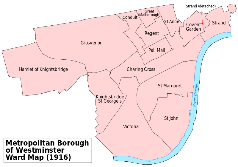
English: A map showing the wards of Westminster Metropolitan Borough as they appeared in 1916. Based on the Ordnance Survey 'County Series 3rd Edition' Map of London (1912-14) Sheets IV12, IV16, V9, V10, V13, V14, IX1 & IX2 at 1:2500 scale. Accessed at http://maps.nls.uk/index.html Reproduced with the permission of the National Library of Scotland. Key: River bank District River Boundaries |
| Datum | |
| Bron | Eigen werk |
| Auteur | Doc77can |
Licentie
Ik, de auteursrechthebbende van dit werk, maak het hierbij onder de volgende licentie beschikbaar:
Dit bestand is gelicenseerd onder de Creative Commons Naamsvermelding-GelijkDelen 4.0 Internationaal licentie.
- De gebruiker mag:
- Delen – het werk kopiëren, verspreiden en doorgeven
- Remixen – afgeleide werken maken
- Onder de volgende voorwaarden:
- naamsvermelding – U moet op een gepaste manier aan naamsvermelding doen, een link naar de licentie geven, en aangeven of er wijzigingen in het werk zijn aangebracht. U mag dit op elke redelijke manier doen, maar niet zodanig dat de indruk wordt gewekt dat de licentiegever instemt met uw werk of uw gebruik van zijn werk.
- Gelijk delen – Als u het werk heeft geremixt, veranderd, of erop heeft voortgebouwd, moet u het gewijzigde materiaal verspreiden onder dezelfde licentie als het oorspronkelijke werk, of een daarmee compatibele licentie.
Bestandsgeschiedenis
Klik op een datum/tijd om het bestand te zien zoals het destijds was.
| Datum/tijd | Miniatuur | Afmetingen | Gebruiker | Opmerking | |
|---|---|---|---|---|---|
| huidige versie | 8 apr 2016 00:24 | | 1.265 × 886 (69 kB) | Doc77can | Converted the labels from paths to text and changed the font. |
| 24 jul 2015 01:30 |  | 1.265 × 886 (400 kB) | Doc77can | User created page with UploadWizard |
Bestandsgebruik
Dit bestand wordt op de volgende pagina gebruikt:
Globaal bestandsgebruik
De volgende andere wiki's gebruiken dit bestand:
- Gebruikt op ar.wikipedia.org
- Gebruikt op azb.wikipedia.org
- Gebruikt op en.wikipedia.org
- Westminster
- Charing Cross
- Knightsbridge
- Metropolitan Borough of Westminster
- Westminster Abbey (UK Parliament constituency)
- Victoria, London
- Westminster St George's (UK Parliament constituency)
- St Anne Within the Liberty of Westminster
- Westminster St Margaret and St John
- User:Doc77can
- User:Moonraker/WM
- Gebruikt op es.wikipedia.org
- Gebruikt op sl.wikipedia.org