Bestand:Westgate Water Tower.jpg
Oorspronkelijk bestand (510 × 800 pixels, bestandsgrootte: 566 kB, MIME-type: image/jpeg)
| Dit is een bestand van Wikimedia Commons. Onderstaande beschrijving komt van de beschrijving van het bestand daar. |
Beschrijving
| Beschrijving |
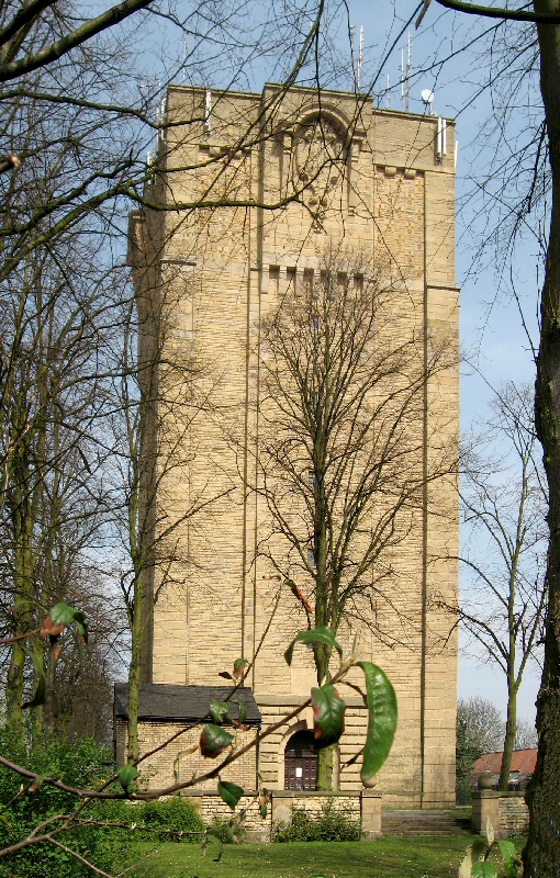
Between November 1904 and April 1905, 1006 people in Lincoln contracted typhoid and of these 113 died. It was Lincoln's biggest peacetime tragedy. The outbreak of the disease was caused by a polluted supply of drinking water, which at the time was taken from a reservoir at Hartsholme (on the edge of the city) and from the River Witham. Despite heavy chlorination of the water public faith in the supply dwindled and many resorted to drawing water from ancient wells. Faced with a crisis situation, city officials and the Water Board realised that the provision of clean water and proper sanitation would be the only way to curb the disease and restore the residents' faith in the public water supply. The first step was to find a suitable source clean water, this was located over the county border at Elkesley in Nottinghamshire where bore holes were sunk through the limestone. (The cores from the boreholes can be seen in this shot taken in The Arboretum in Lincoln). A 22-mile long main was laid from Elksley to Lincoln, where the construction of the Westgate Water Tower was Commissioned by the Lincoln Corporation. The architect, Sir Reginald Blomfield (1856-1942), designed the tower to resemble a medieval keep so as to give a sense of continuity with the city's castle and cathedral. On its completion the Westgate Water Tower had an immediate impact on the city. The local paper "The Lincolnshire Echo" recorded an "air of excitement in the city in anticipation of a new supply of drinking water". This mammoth project was not completed until 1911. Still in use today and a principle source of water for uphill Lincoln the tower, holding some 330,000 gallons (1,356,000 ltrs), remains an imposing landmark visible from miles away. Some facts & figures for the tower:
Some facts & figures for the tank:
|
| Datum | |
| Bron | The Water Tower, Westgate, Lincoln |
| Auteur | Brian from UK |
| Cameralocatie | | Deze en andere afbeeldingen in: OpenStreetMap |
|---|
Licentie
- De gebruiker mag:
- Delen – het werk kopiëren, verspreiden en doorgeven
- Remixen – afgeleide werken maken
- Onder de volgende voorwaarden:
- naamsvermelding – U moet op een gepaste manier aan naamsvermelding doen, een link naar de licentie geven, en aangeven of er wijzigingen in het werk zijn aangebracht. U mag dit op elke redelijke manier doen, maar niet zodanig dat de indruk wordt gewekt dat de licentiegever instemt met uw werk of uw gebruik van zijn werk.
- Gelijk delen – Als u het werk heeft geremixt, veranderd, of erop heeft voortgebouwd, moet u het gewijzigde materiaal verspreiden onder dezelfde licentie als het oorspronkelijke werk, of een daarmee compatibele licentie.
| Deze afbeelding is oorspronkelijk op Flickr geplaatst door Lincolnian op https://www.flickr.com/photos/79727841@N00/465315481. Dit is op 7 mei 2008 door de FlickreviewR-Bot beoordeeld en de licentie onder de voorwaarden van cc-by-sa-2.0 is bevestigd. |
Bestandsgeschiedenis
Klik op een datum/tijd om het bestand te zien zoals het destijds was.
| Datum/tijd | Miniatuur | Afmetingen | Gebruiker | Opmerking | |
|---|---|---|---|---|---|
| huidige versie | 7 mei 2008 00:50 | | 510 × 800 (566 kB) | PC78 | {{Information |Description= Between November 1904 and April 1905, 1006 people in Lincoln contracted typhoid and of these 113 died. It was Lincoln's biggest peacetime tragedy. The outbreak of the disease was caused by a polluted supply of drinking water, |
Bestandsgebruik
Dit bestand wordt op de volgende pagina gebruikt:
Globaal bestandsgebruik
De volgende andere wiki's gebruiken dit bestand:
- Gebruikt op en.wikipedia.org
- Gebruikt op www.wikidata.org