Bestand:Washington, D.C. locator map.svg
Oorspronkelijk bestand(SVG-bestand, nominaal 750 × 550 pixels, bestandsgrootte: 160 kB)


Beschrijving
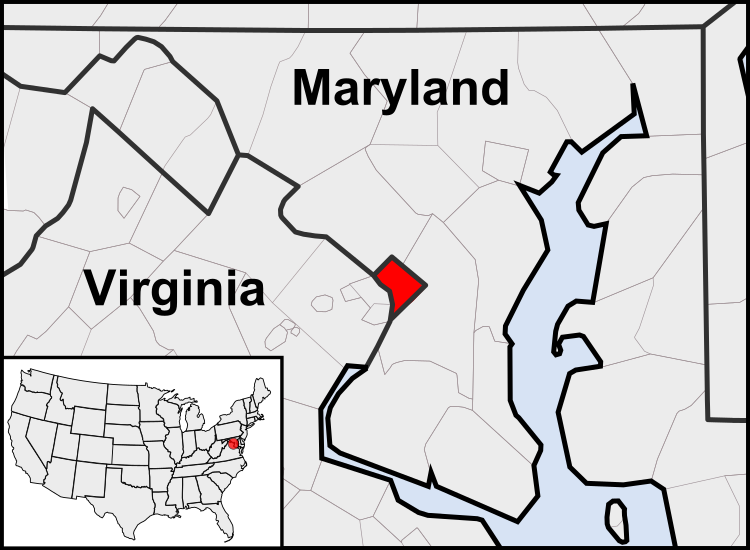
English: This is a map of the location of the District of Columbia showing the borders of states and counties around it.
Datum (UTC)
Bron
Auteur
Andere versies

Afgeleide werken van dit bestand:  United States geographical collation.svg All the below are of the states (and DC) only.
Blank US map.svg Map of states
Labelled US map.svg Map with state labels
USA_blank.svg Image with Hawaii and Alaska in full size
Original blank map of USA and Canada, That image with labels
Original with Hawaii at the natural distance, That original map with labels

File:DC locator map with state names w usmap.png and File:DC locator map with state names.jpg


Dit is een geretoucheerde foto, wat betekent dat de originele versie digitaal aangepast is. Aanpassingen: Cropping to area around District of Columbia. Het origineel kan hier bekeken worden: Blank USA, w territories.svg. Aanpassingen gedaan door Patrickneil.

w:nl:Creative Commons
naamsvermelding Gelijk delen
Dit bestand is gelicenseerd onder de Creative Commons-licentie Naamsvermelding-Gelijk delen 3.0 Unported
De gebruiker mag:
  • Delen – het werk kopiëren, verspreiden en doorgeven
  • Remixen – afgeleide werken maken
Onder de volgende voorwaarden:
  • naamsvermelding – U moet op een gepaste manier aan naamsvermelding doen, een link naar de licentie geven, en aangeven of er wijzigingen in het werk zijn aangebracht. U mag dit op elke redelijke manier doen, maar niet zodanig dat de indruk wordt gewekt dat de licentiegever instemt met uw werk of uw gebruik van zijn werk.
  • Gelijk delen – Als u het werk heeft geremixt, veranderd, of erop heeft voortgebouwd, moet u het gewijzigde materiaal verspreiden onder dezelfde licentie als het oorspronkelijke werk, of een daarmee compatibele licentie.

Oorspronkelijk uploadlogboek

This image is a derivative work of the following images:

  • File:USA_Counties.svg licensed with PD-USGov-DOC-Census
    • 2007-12-23T15:47:48Z Lokal Profil 555x352 (2124572 Bytes) Fixed state borders and fixed the two parts of Fulton County (Kentucky)
    • 2007-12-10T02:20:23Z Lokal Profil 555x352 (2136501 Bytes) Graphical and code cleanup
    • 2007-12-10T01:15:05Z Lokal Profil 792x612 (2135690 Bytes) First stab at a code cleanup
    • 2006-08-29T00:14:37Z Petr Dlouhý 792x612 (2844548 Bytes) Original file: [[:en:Image:USA CountiesSVG.zip]] This [[ZIP (file format)|ZIP]] file contains an [[SVG]] map of the [[United States]] showing the borders of states and counties in high detail. It was derived from [http://ww
  • File:Blank_USA,_w_territories.svg licensed with Cc-by-sa-3.0-migrated, GFDL
    • 2009-01-30T01:59:59Z Hoshie 959x593 (98189 Bytes) Reverted to version as of 23:58, 14 January 2009 - rv myself; DC can be seen clearly.
    • 2009-01-18T23:34:42Z Hoshie 959x593 (102341 Bytes) Put DC in an inset; fixed Tutuila (American Samoa)
    • 2009-01-14T23:58:05Z Lokal Profil 959x593 (98189 Bytes) Code cleanup and removed stroke from Guam and American Samoa
    • 2009-01-13T05:19:51Z Hoshie 959x593 (101361 Bytes) re did Guam and added American Samoa
    • 2007-12-02T16:08:45Z Lokal Profil 959x593 (88960 Bytes) {{Information |Description=A blank map of the United States including Puerto Rico, Guam, the United States Virgin Islands, and the Northern Mariana Islands. |Source=This version was made by [[:User:Lokal_Profil|Lokal_Profil]]

Uploaded with derivativeFX

Bijschriften

Beschrijf in één regel wat dit bestand voorstelt

Items getoond in dit bestand

beeldt af

Bestandsgeschiedenis

Klik op een datum/tijd om het bestand te zien zoals het destijds was.

(nieuwste | oudste) (10 nieuwere | ) (10 | 20 | 50 | 100 | 250 | 500) bekijken.
Datum/tijdMiniatuurAfmetingenGebruikerOpmerking
huidige versie23 jul 2011 05:23Miniatuurafbeelding voor de versie van 23 jul 2011 05:23750 × 550 (160 kB)PatrickneilReverted to version as of 03:04, 23 July 2011
23 jul 2011 05:21Miniatuurafbeelding voor de versie van 23 jul 2011 05:21750 × 550 (161 kB)PatrickneilReverted to version as of 03:14, 23 July 2011
23 jul 2011 05:20Miniatuurafbeelding voor de versie van 23 jul 2011 05:20750 × 550 (161 kB)Patrickneilframe
23 jul 2011 05:14Miniatuurafbeelding voor de versie van 23 jul 2011 05:14750 × 550 (161 kB)Patrickneilthicker frame
23 jul 2011 05:04Miniatuurafbeelding voor de versie van 23 jul 2011 05:04750 × 550 (160 kB)Patrickneilstraightening Maryland and Delaware borders
15 aug 2010 04:09Miniatuurafbeelding voor de versie van 15 aug 2010 04:09750 × 550 (202 kB)PatrickneilDelaware River again
15 aug 2010 03:51Miniatuurafbeelding voor de versie van 15 aug 2010 03:51750 × 550 (274 kB)PatrickneilDelaware River border
15 aug 2010 03:42Miniatuurafbeelding voor de versie van 15 aug 2010 03:42750 × 550 (273 kB)Patrickneilforgot border on Smith Island
15 aug 2010 03:34Miniatuurafbeelding voor de versie van 15 aug 2010 03:34750 × 550 (273 kB)Patrickneilcounty borders below state
15 aug 2010 03:32Miniatuurafbeelding voor de versie van 15 aug 2010 03:32750 × 550 (274 kB)Patrickneilchanges by request
(nieuwste | oudste) (10 nieuwere | ) (10 | 20 | 50 | 100 | 250 | 500) bekijken.

Dit bestand wordt op de volgende pagina gebruikt:

Globaal bestandsgebruik

De volgende andere wiki's gebruiken dit bestand:

Globaal gebruik van dit bestand bekijken.