Bestand:Turkey Regions.png

Grootte van deze voorvertoning: 800 × 357 pixels. Andere resoluties: 320 × 143 pixels | 640 × 285 pixels | 1.278 × 570 pixels.
Oorspronkelijk bestand (1.278 × 570 pixels, bestandsgrootte: 16 kB, MIME-type: image/png)
| Dit is een bestand van Wikimedia Commons. Onderstaande beschrijving komt van de beschrijving van het bestand daar. |


|
This map has been uploaded by Electionworld from en.wikipedia.org to enable the |
Beschrijving
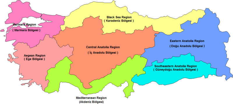
Map of the census-defined regions of Turkey. Names of the regions corrected on original Image (by User Rarelibra).Corrections are made by Mustafa Akalp.
Other versions


Licentie
| Ik, de auteursrechthebbende van dit werk, geef dit werk vrij in het publieke domein. Dit is wereldwijd van toepassing. In sommige landen is dit wettelijk niet mogelijk; in die gevallen geldt: Ik sta iedereen toe dit werk voor eender welk doel te gebruiken, zonder enige voorwaarden, tenzij zulke voorwaarden door de wet worden voorgeschreven. |
Bestandsgeschiedenis
Klik op een datum/tijd om het bestand te zien zoals het destijds was.
| Datum/tijd | Miniatuur | Afmetingen | Gebruiker | Opmerking | |
|---|---|---|---|---|---|
| huidige versie | 29 nov 2010 01:00 | | 1.278 × 570 (16 kB) | Ras67 | cropped and squeezed, transparence |
| 17 dec 2006 12:51 |  | 1.281 × 880 (50 kB) | Electionworld | {{ew|en|Mustafa Akalp}} == Summary == Map of the census-defined regions of Turkey. Names of the regions corrected on original Image (by User Rarelibra).Corrections are made by Mustafa Akalp. == Licensing == {{PD-self}} |
Bestandsgebruik
Dit bestand wordt op de volgende 13 pagina's gebruikt:
- Lijst van regio's van Turkije
- Categorie:Centraal-Anatolië
- Categorie:Egeïsche Zeeregio
- Categorie:Marmararegio
- Categorie:Middellandse Zeeregio
- Categorie:Oost-Anatolië
- Categorie:Regio van Turkije
- Categorie:Zuidoost-Anatolië
- Categorie:Zwarte Zeeregio
- Portaal:Istanbul/Uitgelichte artikels
- Portaal:Istanbul/Uitgelichte artikels/46
- Portaal:Turkije
- Portaal:Turkije/Bestuurlijke indeling
Globaal bestandsgebruik
De volgende andere wiki's gebruiken dit bestand:
- Gebruikt op an.wikipedia.org
- Gebruikt op ar.wikipedia.org
- Gebruikt op ast.wikipedia.org
- Gebruikt op ay.wikipedia.org
- Gebruikt op ba.wikipedia.org
- Gebruikt op be-tarask.wikipedia.org
- Gebruikt op be.wikipedia.org
- Gebruikt op el.wikipedia.org
- Gebruikt op en.wikipedia.org
- Gebruikt op es.wikipedia.org
- Gebruikt op eu.wikipedia.org
- Gebruikt op fr.wikipedia.org
- Gebruikt op gl.wikipedia.org
- Gebruikt op hu.wikipedia.org
- Törökország földrajza
- Égei-tengeri régió
- Fekete-tengeri régió
- Márvány-tengeri régió
- Földközi-tengeri régió
- Sablon:Törökország régiói
- Törökország régiói
- Törökország közigazgatási egységei
- Közép-anatóliai régió
- Kelet-anatóliai régió
- Délkelet-anatóliai régió
- Törökország turisztikai látnivalói régiók szerint
- Szerkesztő:Kaleido1000/Földrajzi navigációs sablonok/Országok tartományai, települései, stb
- Gebruikt op hy.wikipedia.org
- Gebruikt op hyw.wikipedia.org
- Gebruikt op it.wikipedia.org
- Gebruikt op ja.wikipedia.org
- Gebruikt op ja.wikibooks.org
- Gebruikt op jv.wikipedia.org
- Gebruikt op koi.wikipedia.org
- Gebruikt op ko.wikipedia.org
- Gebruikt op lrc.wikipedia.org
- Gebruikt op mrj.wikipedia.org
- Gebruikt op ms.wikipedia.org
Globaal gebruik van dit bestand bekijken.