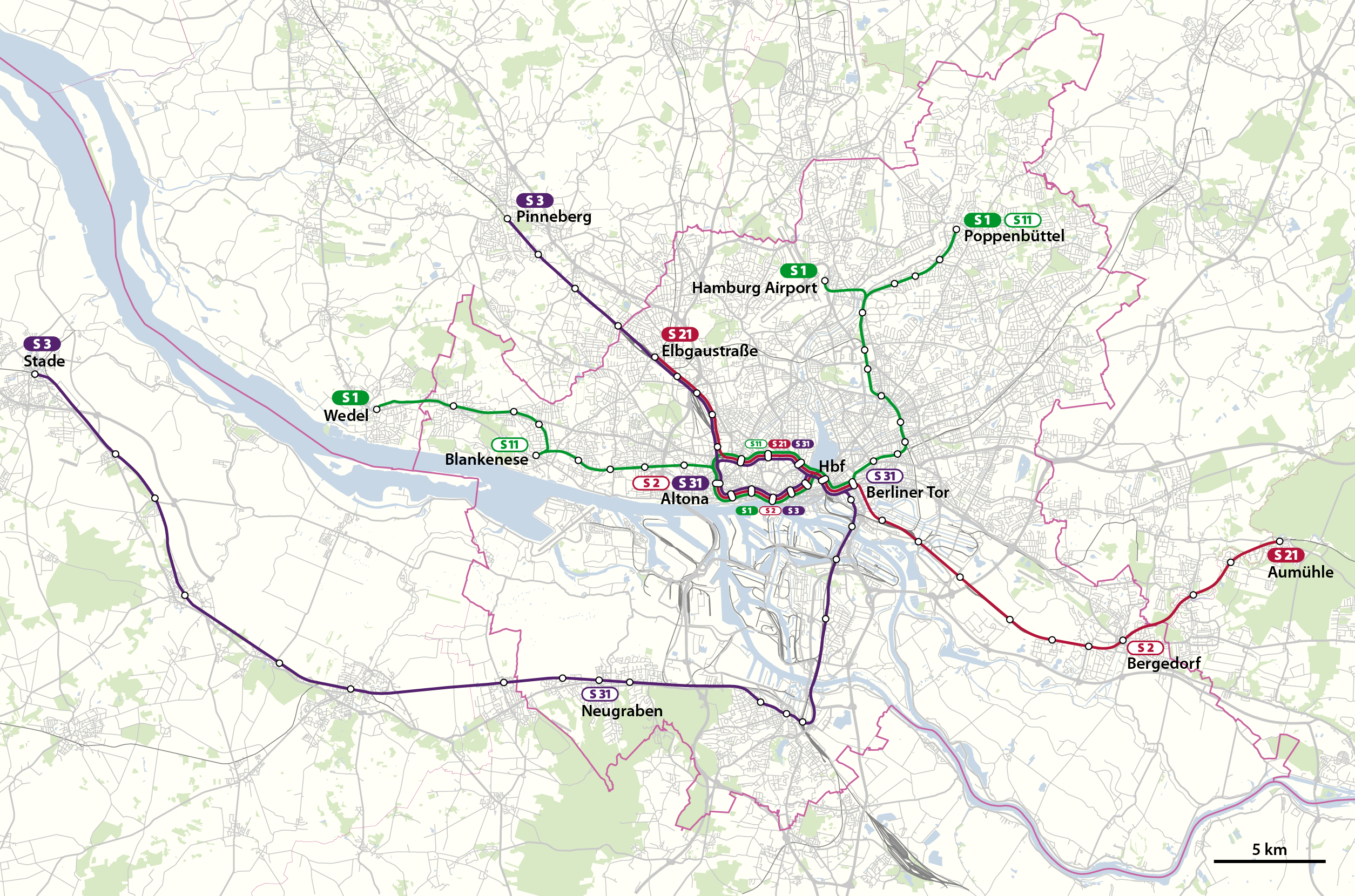
Bestand:Topografischer Netzplan S-Bahn Hamburg.png
Grootte van deze voorvertoning: 800 × 529 pixels. Andere resoluties: 320 × 212 pixels | 640 × 423 pixels | 1.024 × 677 pixels | 1.280 × 847 pixels | 2.509 × 1.660 pixels.
Oorspronkelijk bestand (2.509 × 1.660 pixels, bestandsgrootte: 1,31 MB, MIME-type: image/png)
| Dit is een bestand van Wikimedia Commons. Onderstaande beschrijving komt van de beschrijving van het bestand daar. |
Beschrijving
| Beschrijving |
Deutsch: Topographischer Netzplan der S-Bahn Hamburg
English: Topographical network map of the Hamburg S-Bahn |
||||||||||||
| Datum | |||||||||||||
| Bron | Eigen werk, using OpenStreetMap data | ||||||||||||
| Auteur | NordNordWest | ||||||||||||
| Toestemming (Hergebruik van dit bestand) |
|

|
Deze kaart is gemaakt of verbeterd in de Duitse Kartenwerkstatt (Map Lab). Je kunt ook zelf kaarten ter verbetering voorstellen.
|
Bestandsgeschiedenis
Klik op een datum/tijd om het bestand te zien zoals het destijds was.
| Datum/tijd | Miniatuur | Afmetingen | Gebruiker | Opmerking | |
|---|---|---|---|---|---|
| huidige versie | 14 dec 2019 18:40 | | 2.509 × 1.660 (1,31 MB) | NordNordWest | upd |
| 25 jan 2011 20:17 |  | 2.509 × 1.660 (1,17 MB) | NordNordWest | upd | |
| 14 feb 2010 18:24 |  | 2.509 × 1.660 (1 MB) | NordNordWest | c | |
| 13 feb 2010 19:09 |  | 2.509 × 1.660 (1,01 MB) | NordNordWest | + | |
| 7 feb 2010 19:45 |  | 2.509 × 1.660 (1 MB) | NordNordWest | + | |
| 6 feb 2010 23:05 |  | 1.361 × 900 (456 kB) | NordNordWest | == {{int:filedesc}} == {{Information |Description= {{de|Topographischer Netzplan der S-Bahn Hamburg}} {{en|Topographical network map of the Hamburg S-Bahn}} |Source={{Own}}, using OpenStreetMap data |Date=201 |
Bestandsgebruik
Dit bestand wordt op de volgende pagina gebruikt:
Globaal bestandsgebruik
De volgende andere wiki's gebruiken dit bestand:
- Gebruikt op de.wikipedia.org
- Gebruikt op hu.wikipedia.org
- Gebruikt op www.wikidata.org