Bestand:The Old Town Hall - geograph.org.uk - 1042854.jpg
The_Old_Town_Hall_-_geograph.org.uk_-_1042854.jpg (640 × 426 pixels, bestandsgrootte: 82 kB, MIME-type: image/jpeg)
| Dit is een bestand van Wikimedia Commons. Onderstaande beschrijving komt van de beschrijving van het bestand daar. |
Beschrijving
| Beschrijving |
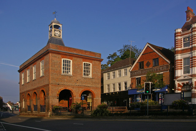
English: The Old Town Hall. This grade II* listed building (for listing particulars see http://www.heritagegateway.org.uk/Gateway/Results_Single.aspx?uid=289342&resourceID=5) was built in around 1728 as a replacement market hall for a similar building that once stood near West Street.
The cupola and clock were added in 1811 having been removed from the recently demolished nearby town prison ("the cage" - a new prison cage was built in what is now Cage Yard - see 1042857). In 1853, a chimney was added in each corner during alterations carried out by Lord Somers (who owned much of Reigate at the time) - they were removed in the 1980s, being out of keeping with the remainder of the building. It served as the town hall from 1863 to 1901, when the role transferred to the new municipal buildings in Castlefield Road (see 630757), after which it gained the name "Old Town Hall" by which it is now generally known. The building was used for petty court sessions from 1876, magistrates sitting there into the 1880s. It has been owned by the local council since 1922, with recent use including art and photographic exhibitions. However, following much debate over a longer term use to justify restoration, in 2008 it became a Caffe Nero coffee shop. Note the reference to a former user of the shop premises to the right of the building (now Carphone Warehouse) - Eames Outfitters; the building itself dates from the early 17th century and is grade II listed. |
| Datum | |
| Bron | From geograph.org.uk |
| Auteur | Ian Capper |
| Naamsvermelding (required by the license) | Ian Capper / The Old Town Hall / |
| Cameralocatie | | Deze en andere afbeeldingen in: OpenStreetMap |
|---|
_heading:292.00&language=nl)
| Objectlocatie | | Deze en andere afbeeldingen in: OpenStreetMap |
|---|
_heading:292.00&language=nl)
Licentie

|
Deze afbeelding komt uit de Geograph British Isles-collectie. Zie de pagina van deze foto op de website van Geograph voor contactinformatie van de fotograaf. Het auteursrecht van deze foto is in handen van Ian Capper en de foto is gelicenceerd voor hergebruik onder de Creative Commons Naamsvermelding-Gelijk delen 2.0 licentie.
|
- De gebruiker mag:
- Delen – het werk kopiëren, verspreiden en doorgeven
- Remixen – afgeleide werken maken
- Onder de volgende voorwaarden:
- naamsvermelding – U moet op een gepaste manier aan naamsvermelding doen, een link naar de licentie geven, en aangeven of er wijzigingen in het werk zijn aangebracht. U mag dit op elke redelijke manier doen, maar niet zodanig dat de indruk wordt gewekt dat de licentiegever instemt met uw werk of uw gebruik van zijn werk.
- Gelijk delen – Als u het werk heeft geremixt, veranderd, of erop heeft voortgebouwd, moet u het gewijzigde materiaal verspreiden onder dezelfde licentie als het oorspronkelijke werk, of een daarmee compatibele licentie.
Bestandsgeschiedenis
Klik op een datum/tijd om het bestand te zien zoals het destijds was.
| Datum/tijd | Miniatuur | Afmetingen | Gebruiker | Opmerking | |
|---|---|---|---|---|---|
| huidige versie | 24 feb 2011 00:41 | | 640 × 426 (82 kB) | GeographBot | == {{int:filedesc}} == {{Information |description={{en|1=The Old Town Hall This grade II* listed building (for listing particulars see http://www.heritagegateway.org.uk/Gateway/Results_Single.aspx?uid=289342&resourceID=5) was built in around 1728 as a rep |
Bestandsgebruik
Dit bestand wordt op de volgende pagina gebruikt:
Globaal bestandsgebruik
De volgende andere wiki's gebruiken dit bestand:
- Gebruikt op azb.wikipedia.org
- Gebruikt op en.wikipedia.org
- Gebruikt op en.wikivoyage.org
- Gebruikt op fa.wikipedia.org
- Gebruikt op lt.wikipedia.org
- Gebruikt op pt.wikipedia.org
- Gebruikt op ru.wikipedia.org
- Gebruikt op zh.wikipedia.org