Bestand:The Old Chapel, Creslow - geograph.org.uk - 234817.jpg
Geen hogere resolutie beschikbaar.
The_Old_Chapel,_Creslow_-_geograph.org.uk_-_234817.jpg (640 × 480 pixels, bestandsgrootte: 81 kB, MIME-type: image/jpeg)
| Dit is een bestand van Wikimedia Commons. Onderstaande beschrijving komt van de beschrijving van het bestand daar. |
Beschrijving
| Beschrijving |
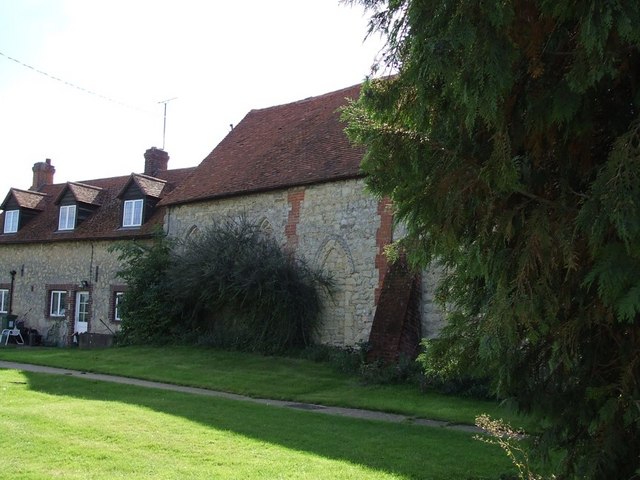
English: The Old Chapel, Creslow. This chapel is marked on the map and edged in black suggesting it is a public building, but it looks to me as though it has been incorporated into the adjoining building. The only signs were ones informing that there was no right of way for the public - so at best it probably has a very small congregation !
Edit: According to the English Heritage Viewfinder website "The former parish church, which ceased being used in the 18th century, was first a dovecot and is now used as an outbuilding of the Manor House. " ( See http://viewfinder.english-heritage.org.uk/search/reference.asp?index=385&imageUID=51561&main_query=&theme=&period=&county=&district=&place_name=Ham ) However the BHO website (see http://www.british-history.ac.uk/report.aspx?compid=42572&strquery=Parish%20Creslow#s3 ) itself quoting the "History of the County of Buckingham" suggests that it had not been used as a church since the time of Elizabeth I (1558-1603). A list of the rectors (see http://met.open.ac.uk/genuki/big/eng/BKM/Creslow/rectors.html ) finishes with the appointment of Thomas Davis A.M. in 1554 - which serves to confirm this earlier date.
|
|
| Datum | ||
| Bron | From geograph.org.uk | |
| Auteur | Rob Farrow | |
| Naamsvermelding (required by the license) | Rob Farrow / The Old Chapel, Creslow / | |
| Objectlocatie | | Deze en andere afbeeldingen in: OpenStreetMap |
|---|
_heading:135.00&language=nl)
Licentie

|
Deze afbeelding komt uit de Geograph British Isles-collectie. Zie de pagina van deze foto op de website van Geograph voor contactinformatie van de fotograaf. Het auteursrecht van deze foto is in handen van Rob Farrow en de foto is gelicenceerd voor hergebruik onder de Creative Commons Naamsvermelding-Gelijk delen 2.0 licentie.
|
Dit bestand is gelicenseerd onder de Creative Commons-licentie Naamsvermelding-Gelijk delen 2.0 Unported
Naamsvermelding: Rob Farrow
- De gebruiker mag:
- Delen – het werk kopiëren, verspreiden en doorgeven
- Remixen – afgeleide werken maken
- Onder de volgende voorwaarden:
- naamsvermelding – U moet op een gepaste manier aan naamsvermelding doen, een link naar de licentie geven, en aangeven of er wijzigingen in het werk zijn aangebracht. U mag dit op elke redelijke manier doen, maar niet zodanig dat de indruk wordt gewekt dat de licentiegever instemt met uw werk of uw gebruik van zijn werk.
- Gelijk delen – Als u het werk heeft geremixt, veranderd, of erop heeft voortgebouwd, moet u het gewijzigde materiaal verspreiden onder dezelfde licentie als het oorspronkelijke werk, of een daarmee compatibele licentie.
Bestandsgeschiedenis
Klik op een datum/tijd om het bestand te zien zoals het destijds was.
| Datum/tijd | Miniatuur | Afmetingen | Gebruiker | Opmerking | |
|---|---|---|---|---|---|
| huidige versie | 1 feb 2010 04:29 | | 640 × 480 (81 kB) | GeographBot | == {{int:filedesc}} == {{Information |description={{en|1=The Old Chapel, Creslow. This chapel is marked on the map and edged in black suggesting it is a public building, but it looks to me as though it has been incorporated into the adjoining building. Th |
Bestandsgebruik
Dit bestand wordt op de volgende pagina gebruikt:
Globaal bestandsgebruik
De volgende andere wiki's gebruiken dit bestand:
- Gebruikt op ar.wikipedia.org
- Gebruikt op arz.wikipedia.org
- Gebruikt op ceb.wikipedia.org
- Gebruikt op cy.wikipedia.org
- Gebruikt op en.wikipedia.org
- Gebruikt op fr.wikipedia.org
- Gebruikt op lld.wikipedia.org
- Gebruikt op pl.wikipedia.org
- Gebruikt op sv.wikipedia.org
- Gebruikt op www.wikidata.org