Bestand:Tephra fall from 1991 eruption of Mt Pinatubo.gif

Geen hogere resolutie beschikbaar.
Tephra_fall_from_1991_eruption_of_Mt_Pinatubo.gif (600 × 425 pixels, bestandsgrootte: 25 kB, MIME-type: image/gif)
| Dit is een bestand van Wikimedia Commons. Onderstaande beschrijving komt van de beschrijving van het bestand daar. |
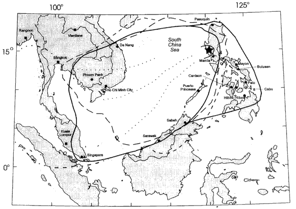
Area over which tephra from 1991 eruption of Mt Pinatubo fell.
Deze afbeelding bevindt zich in het publiek domein omdat het materiaal bevat dat oorspronkelijk afkomstig is van de United States Geological Survey, een agentschap van de United States Department of the Interior. Voor meer informatie, zie het officiële USGS-auteursrechtenbeleid
|
Bestandsgeschiedenis
Klik op een datum/tijd om het bestand te zien zoals het destijds was.
| Datum/tijd | Miniatuur | Afmetingen | Gebruiker | Opmerking | |
|---|---|---|---|---|---|
| huidige versie | 8 mrt 2006 11:35 | | 600 × 425 (25 kB) | Magalhães | Area over which tephra from 1991 eruption of Mt Pinatubo fell. Source: [http://pubs.usgs.gov/pinatubo/paladio/fig9.gif Fig.9] on [http://pubs.usgs.gov/pinatubo/paladio]. {{PD-USGov-Interior-USGS}} |
Bestandsgebruik
Dit bestand wordt op de volgende pagina gebruikt:
Globaal bestandsgebruik
De volgende andere wiki's gebruiken dit bestand:
- Gebruikt op en.wikipedia.org
- Gebruikt op he.wikipedia.org
- Gebruikt op ja.wikipedia.org
- Gebruikt op pam.wikipedia.org
- Gebruikt op uk.wikipedia.org
- Gebruikt op zh.wikipedia.org