Bestand:Stockholm commuter rail geographic map.png
Grootte van deze voorvertoning: 514 × 600 pixels. Andere resoluties: 206 × 240 pixels | 411 × 480 pixels | 658 × 768 pixels | 878 × 1.024 pixels | 1.800 × 2.100 pixels.
Oorspronkelijk bestand (1.800 × 2.100 pixels, bestandsgrootte: 1,19 MB, MIME-type: image/png)
| Dit is een bestand van Wikimedia Commons. Onderstaande beschrijving komt van de beschrijving van het bestand daar. |
Beschrijving
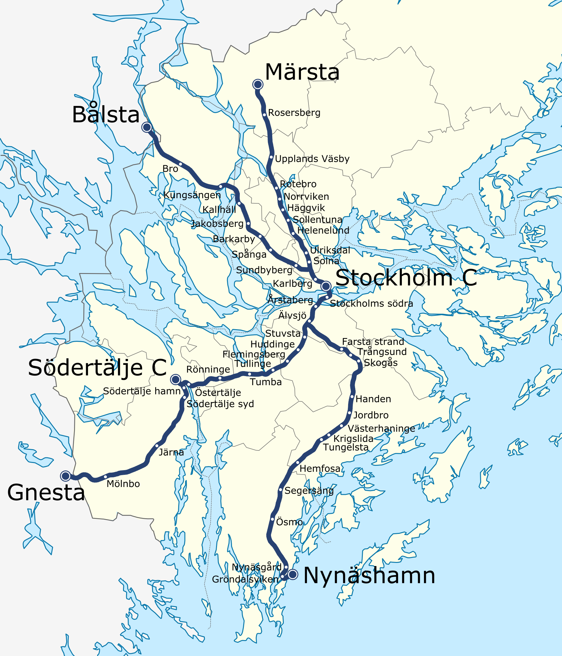
Stockholm commuter rail map with basic geographic features. Based on File:Sweden Stockholm location map.svg by User:Erik Frohne and File:Stockholm commuter rail map.svg by User:Kildor.
This is a png export of File:Stockholm commuter rail geographic map.svg (for the purpose of having better text rendering; the svg to png conversion does not work well at wikimedia/commons).
Licentie
Dit bestand is gelicenseerd onder de Creative Commons-licentie Naamsvermelding-Gelijk delen 3.0 Unported
- De gebruiker mag:
- Delen – het werk kopiëren, verspreiden en doorgeven
- Remixen – afgeleide werken maken
- Onder de volgende voorwaarden:
- naamsvermelding – U moet op een gepaste manier aan naamsvermelding doen, een link naar de licentie geven, en aangeven of er wijzigingen in het werk zijn aangebracht. U mag dit op elke redelijke manier doen, maar niet zodanig dat de indruk wordt gewekt dat de licentiegever instemt met uw werk of uw gebruik van zijn werk.
- Gelijk delen – Als u het werk heeft geremixt, veranderd, of erop heeft voortgebouwd, moet u het gewijzigde materiaal verspreiden onder dezelfde licentie als het oorspronkelijke werk, of een daarmee compatibele licentie.
Bestandsgeschiedenis
Klik op een datum/tijd om het bestand te zien zoals het destijds was.
| Datum/tijd | Miniatuur | Afmetingen | Gebruiker | Opmerking | |
|---|---|---|---|---|---|
| huidige versie | 22 aug 2009 20:19 | | 1.800 × 2.100 (1,19 MB) | Kildor | larger station names, slightly different station markers |
| 22 aug 2009 12:24 |  | 1.800 × 2.100 (1,16 MB) | Kildor | higher resolution | |
| 22 aug 2009 11:44 |  | 600 × 700 (281 kB) | Kildor | Stockholm commuter rail map with basic geographic features. Based on File:Sweden Stockholm location map.svg by User:Erik Frohne and File:Stockholm commuter rail map.svg by User:Kildor. |
Bestandsgebruik
Dit bestand wordt op de volgende pagina gebruikt:
Globaal bestandsgebruik
De volgende andere wiki's gebruiken dit bestand:
- Gebruikt op da.wikipedia.org
- Gebruikt op fr.wikipedia.org
- Gebruikt op pl.wikipedia.org
- Gebruikt op www.wikidata.org