Bestand:Sino-Indian Geography.png
Oorspronkelijk bestand (918 × 648 pixels, bestandsgrootte: 1,36 MB, MIME-type: image/png)
| Dit is een bestand van Wikimedia Commons. Onderstaande beschrijving komt van de beschrijving van het bestand daar. |
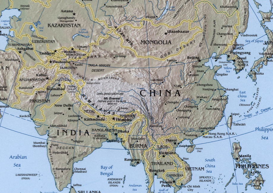
A map showing the geography of the Sino-Indian region.
A physical map with relief showing shading. Scale 1:48,000,000 ; Azimuthal equal-area projection (W 50--W 1650/N 880--S 180).
Cropped from a larger map showing Asia - which may be found on the Library of Congress website (the source image) or alternatively on the CIA World Factbook.
Image created and published by the Central Intelligence Agency of the United States of America in 2004.
Note
The land border between the China and India over Arunachal Pradesh / South Tibet reflects actual control, without dotted line showing claims
Deze afbeelding bevindt zich in het publiek domein omdat het materiaal bevat dat oorspronkelijk afkomstig is van het CIA World Factbook.
|
 |
Bestandsgeschiedenis
Klik op een datum/tijd om het bestand te zien zoals het destijds was.
| Datum/tijd | Miniatuur | Afmetingen | Gebruiker | Opmerking | |
|---|---|---|---|---|---|
| huidige versie | 22 nov 2004 21:32 | | 918 × 648 (1,36 MB) | OldakQuill | |
| 22 nov 2004 11:38 |  | 354 × 350 (98 kB) | OldakQuill | A map showing the geography of the Sino-Indian region. {{pd}} |
Bestandsgebruik
Dit bestand wordt op de volgende pagina gebruikt:
Globaal bestandsgebruik
De volgende andere wiki's gebruiken dit bestand:
- Gebruikt op ar.wikipedia.org
- Gebruikt op de.wikipedia.org
- Gebruikt op en.wikipedia.org
- Gebruikt op fa.wikipedia.org
- Gebruikt op fr.wikipedia.org
- Gebruikt op ha.wikipedia.org
- Gebruikt op hi.wikipedia.org
- Gebruikt op hy.wikipedia.org
- Gebruikt op id.wikipedia.org
- Gebruikt op mn.wikipedia.org
- Gebruikt op ms.wikipedia.org
- Gebruikt op pnb.wikipedia.org
- Gebruikt op ru.wikipedia.org
- Gebruikt op sr.wikipedia.org
- Gebruikt op tr.wikipedia.org
- Gebruikt op uk.wikipedia.org
- Gebruikt op ur.wikipedia.org
- Gebruikt op uz.wikipedia.org
- Gebruikt op www.wikidata.org
- Gebruikt op zh.wikipedia.org