Bestand:Serranilla Bank marked satellite map.png

Oorspronkelijk bestand (1.600 × 1.050 pixels, bestandsgrootte: 1,6 MB, MIME-type: image/png)
| Dit is een bestand van Wikimedia Commons. Onderstaande beschrijving komt van de beschrijving van het bestand daar. |
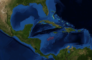
| Beschrijving | Satellite picture of Caribbean Sea with location of Serranilla Bank marked, from NASA World Wind Globe, version 1.4 |
| Datum | (UTC) |
| Bron | |
| Auteur |
|
| Dit is een geretoucheerde foto, wat betekent dat de originele versie digitaal aangepast is. Aanpassingen: Marked location of Serranilla Bank. Het origineel kan hier bekeken worden: Amerikanisches Mittelmeer NASA World Wind Globe .jpg. Aanpassingen gedaan door Nihonjoe.
|

|
Dit werk is vrije software; u mag de software heruitgeven en/of aanpassen in overeenkomst met de voorwaarden van de GNU Lesser General Public License zoals gepubliceerd door de Free Software Foundation. De geldende versie is 2 van de Licentie, of enige latere versie. Dit werk wordt gedistribueerd in de hoop dat het bruikbaar is, maar zonder enige garantie; zelfs zonder de impliciete garantie van goede werking of geschiktheid voor een bepaald doel. Zie versie 2 en versie 3 van de GNU General Public License voor meer details. |
| Deze afbeelding bevindt zich in het publiek domein omdat het een screenshot is van NASA’s software World Wind die gebruik maakt van een publiek domein-laag, zoals Blue Marble, MODIS, Landsat, SRTM, USGS of GLOBE.
|
 |
Oorspronkelijk uploadlogboek
This image is a derivative work of the following images:
- File:Amerikanisches_Mittelmeer_NASA_World_Wind_Globe_.jpg licensed with GPL, PD-WorldWind
- 2008-06-22T16:30:28Z ILA-boy 1600x1050 (770588 Bytes) {{Information |Description=Satellite pictures, from NASA World Wind Globe, version 1.4 |Source=own work |Date=June 2008 |Author=[[User:ILA-boy|ILA-boy]] |Permission=GNU General Public License |other_versions= }} {{GPL}} [[C
Uploaded with derivativeFX
Bestandsgeschiedenis
Klik op een datum/tijd om het bestand te zien zoals het destijds was.
| Datum/tijd | Miniatuur | Afmetingen | Gebruiker | Opmerking | |
|---|---|---|---|---|---|
| huidige versie | 31 mei 2009 03:53 | | 1.600 × 1.050 (1,6 MB) | Nihonjoe | {{Information |Description=Satellite picture of Caribbean Sea with location of Serranilla Bank marked, from NASA World Wind Globe, version 1.4 |Source=*File:Amerikanisches_Mittelmeer_NASA_World_Wind_Globe_.jpg |Date=2009- |
Bestandsgebruik
Dit bestand wordt op de volgende pagina gebruikt:
Globaal bestandsgebruik
De volgende andere wiki's gebruiken dit bestand:
- Gebruikt op es.wikipedia.org
- Gebruikt op fi.wikipedia.org
- Gebruikt op id.wikipedia.org
- Gebruikt op ja.wikipedia.org
- Gebruikt op mk.wikipedia.org
- Gebruikt op ml.wikipedia.org
- Gebruikt op ru.wikipedia.org
- Gebruikt op simple.wikipedia.org
- Gebruikt op sv.wikipedia.org
- Gebruikt op www.wikidata.org