Bestand:Sault Ste Marie, Ontario and Michigan.JPG

Grootte van deze voorvertoning: 398 × 599 pixels. Andere resoluties: 159 × 240 pixels | 319 × 480 pixels | 510 × 768 pixels | 680 × 1.024 pixels | 1.360 × 2.048 pixels | 2.848 × 4.288 pixels.
Oorspronkelijk bestand (2.848 × 4.288 pixels, bestandsgrootte: 8,47 MB, MIME-type: image/jpeg)
| Dit is een bestand van Wikimedia Commons. Onderstaande beschrijving komt van de beschrijving van het bestand daar. |
Beschrijving
| Beschrijving |
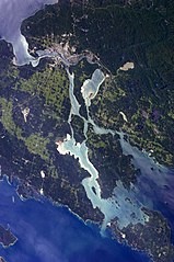
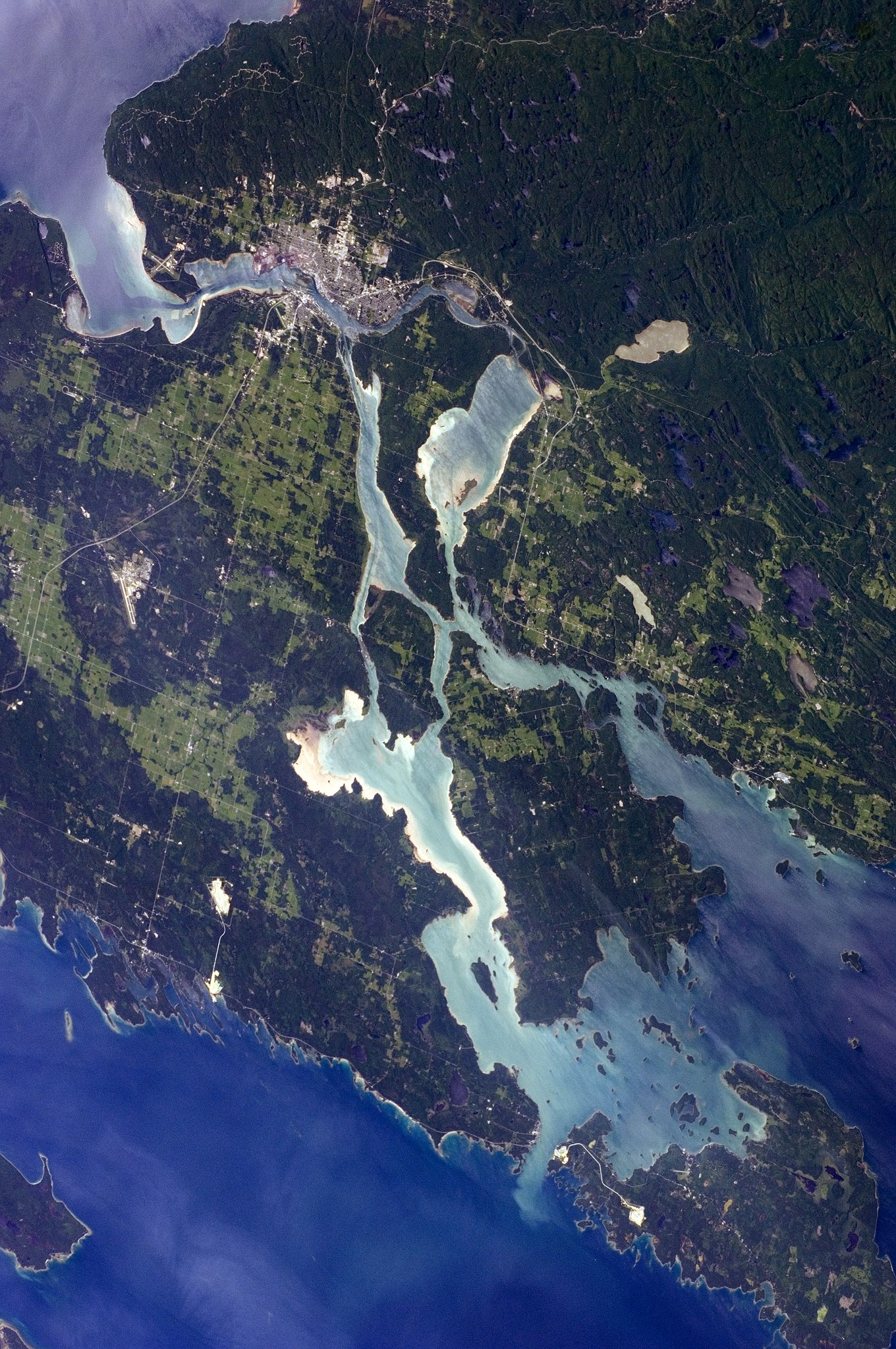
English: The twin cities of Sault Ste Marie are located across the St. Mary’s River, which forms part of the international boundary between Canada (Province of Ontario) and the United States (State of Michigan). This astronaut photograph highlights the two cities, as well as the lakes and islands that separate Lakes Huron and Superior, two of the Great Lakes of North America. Smaller lakes include Lake George to the west, and the large forested islands of St. Joseph and Drummond are visible at image upper left.
The Sault Ste Marie urban areas (image lower left) have a distinctive gray to white colour, contrasting with the deep green of forested areas in Ontario and the lighter green of agricultural fields in Michigan. The water surfaces in the lakes and rivers vary from blue to blue-green to silver, likely the result of varying degrees of sediment and sunglint—light reflecting from the water surface back to the International Space Station. |
| Datum | |
| Bron | NASA Earth Observatory |
| Auteur | ISS Expedition 28 crew |
| Cameralocatie | | Deze en andere afbeeldingen in: OpenStreetMap |
|---|
Deze afbeelding of video is gecatalogiseerd door Johnson Space Center van de Verenigde Staten National Aeronautics and Space Administration (NASA)onder Foto ID: ISS028-E-10162.Deze banner zegt niets over de auteursrechten die van toepassing zijn. Een normale auteursrechten-tag is nodig. Zie Commons:Licensing voor meer informatie. Andere talen:
|
Image acquired with a Nikon D2Xs digital camera using a 110 mm lens, and is provided by the ISS Crew Earth Observations experiment and Image Science & Analysis Laboratory, Johnson Space Center.
Licentie
| Dit bestand bevindt zich in het publiek domein, omdat het gemaakt is door de NASA. In de reproductierichtlijnen van de NASA staat dat "NASA-materiaal niet beschermd wordt door auteursrecht, tenzij anders vermeld". | ||
 |
Waarschuwingen:
|
| Aantekeningen | Deze afbeelding is aangetekend: Bekijk de aantekeningen op Commons |
Bestandsgeschiedenis
Klik op een datum/tijd om het bestand te zien zoals het destijds was.
| Datum/tijd | Miniatuur | Afmetingen | Gebruiker | Opmerking | |
|---|---|---|---|---|---|
| huidige versie | 18 aug 2018 14:12 | | 2.848 × 4.288 (8,47 MB) | Ras67 | new rendered from NASA's raw image date with real quality and without clipped highlights |
| 23 feb 2013 22:48 |  | 2.848 × 4.288 (12,03 MB) | Rotatebot | Bot: Image rotated by 90° | |
| 11 jul 2011 14:20 |  | 4.288 × 2.848 (10,92 MB) | Originalwana | {{Information |Description ={{en|1=The twin cities of Sault Ste Marie are located across the St. Mary’s River, which forms part of the international boundary between Canada (Province of Ontario) and the United S |
Bestandsgebruik
Dit bestand wordt op de volgende pagina gebruikt:
Globaal bestandsgebruik
De volgende andere wiki's gebruiken dit bestand:
- Gebruikt op ar.wikipedia.org
- Gebruikt op el.wikipedia.org
- Gebruikt op en.wikipedia.org
- Gebruikt op et.wikipedia.org
- Gebruikt op fa.wikipedia.org
- Gebruikt op fi.wikipedia.org
- Gebruikt op it.wikipedia.org